Our voyage starts at the Potomac River entrance to the long Occoquan River access channel, which begins off High Point. This bay is otherwise shallow throughout. In addition to recreational boats, there’s commercial tug and barge traffic transiting to and from a sand and gravel landing just upriver from the Route 1 Bridge. At High Point (Site 1), the shoreline falls off sharply to the northwest. There is fallen timber all along this high bank, providing plenty of targets to cast to for bass, crappie, perch, and rockfish, depending on the season. Segmented breakwaters at Site 2 provide additional structure. Immediately upriver of the northwesternmost breakwater is a dike armored with rock on both sides. The dike separates the bay and tidal action from a large upland freshwater marsh. Between the dike and Site 3 is another group of segmented breakwaters.
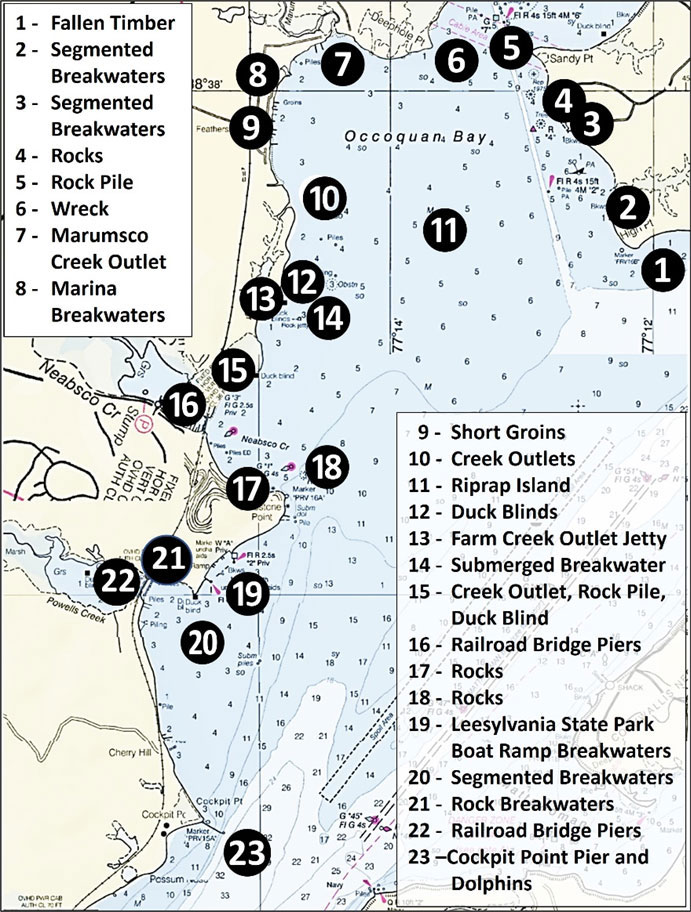
There are a few scattered but significant rocks (Site 4) charted between the shoreline and the channel running northwest to Sandy Point. A 1973 hydrographic survey found a rock approximately 10 feet in diameter that is uncovered at mean low water at coordinates of 38°37.792 x 77°12.853. The high bank shoreline is characterized by fallen timber all the way to the point. Look for a large rock pile (Site 5) immediately northwest of Sandy Point. The rocks are uncovered at low water and were marked by a duck blind beginning circa 2016. The rocks appeared more natural than smaller rocks that can be manhandled and are typically seen in ballast piles.
Site 6 off Deephole Point is an old wreck (charted coordinates 38°38.200 x 77°13.551) but nothing is visible. However, there’s also a charted three-foot wreck at coordinates 38'38.563 x 77'13.256 located on the other side of the river to the north northwest.
Catamount Creek and three unnamed small creeks discharge through outlets under Deephole Point Road, which runs along the shoreline. Most of the shoreline is armored with gabion-sized rock. There is a section of riprap rock armor as the shoreline approaches Marumsco Creek. Just beyond this riprap is a double row of concrete pipes as well as several scattered concrete pipes that end at a submerged spit on the east side of Marumsco Creek opening. The shoreline immediately to the east is also armored with rock. The creek itself has enough water to access on a rising tide.
Southeast of the creek are the substantial rock breakwaters (Site 8) for the Tyme N’ Tyde marina. A small creek discharges along the north side of the marina breakwater. South of the marina, the shoreline turns residential before intersecting Featherstone National Wildlife Refuge. The residential shorefront, shown as Site 9, has docks and pilings as well as a number of short rock groins.
Featherstone Refuge extends all the way down to Neabsco Creek. Fallen timber is all along this shoreline. Two small creek outlets are marked as Site 10. The creeks drain fringe marshes. There is some structure to cast to in the form of old and active duck blinds from there south to the entrance of Farm Creek.
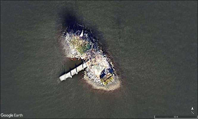
Due east of the refuge in the center of the bay at coordinates 38'37.248 x 77'13.584 is an artificial island (Site 11) shown in Image 1. It’s recorded in Prince William County land records as Holiday Island and is privately owned. Some Nautical charts label it as Smoots Island which immediately flags the island as related to sand and gravel mining. A combination of land records and anecdotal oral histories indeed lead to Smoot Sand and Gravel Corporation as the party that created the island. Internet lore says that in the mid-1920s Smoot wanted a duck hunting site. So, one night, one or two barges were taken to the site, sunk, and subsequently filled with rock.
The island first appears on a nautical chart in 1936 as a square box. The feature currently includes a foundation slab with a flagpole at the north corner on a mound surrounded by rock armor. There’s also a dock on the southwest side and a marker on a piling on the northeast side. Regardless of how the island got there, it provides subsurface structure and opportunities for catching fish.
Moving back to the bay’s western shoreline, look for a duck blind in the vicinity of Site 12. The entrance to Farm Creek is at Site 13. There’s a short but substantial rock groin on its east side. The entrance is very shallow but is a little deeper once inside. This is trolling motor or kayak water. Guide Andy Andrzejewski, in an article circa 2012, said there was an old causeway with lines of pilings that uncover at low tide. This feature is indeed there immediately south of where the marsh widens and a feeder creek enters the main creek. The southern row is almost gone with only a couple showing in the creek channel. The northern line extends all the way across the creek.
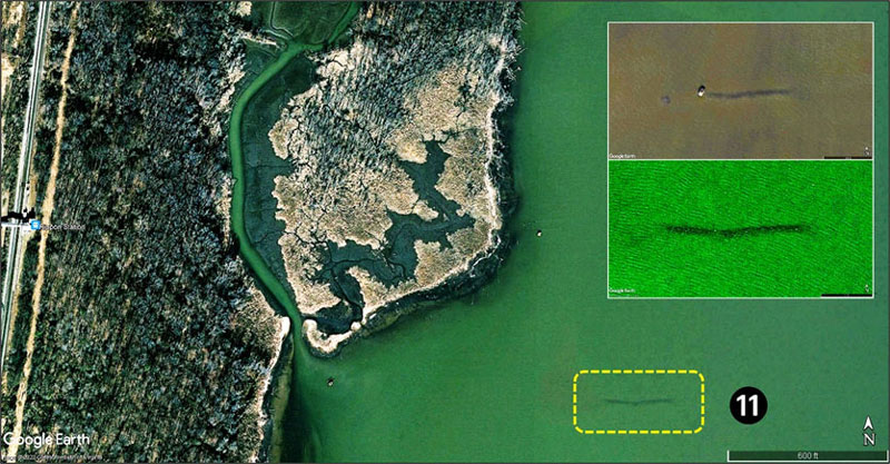
Four hundred yards east-southeast of the Farm Creek entrance jetty at Site 14 is the west end of a submerged rock jetty or breakwater at coordinates 38'36.636 x 77'14.746. It’s oriented east-west and is about 100 yards in length. This charted feature, which appears to consist of gabion-size rock, is a major danger to navigation but also provides structural habitat and fishing opportunity. The structure first appears on nautical charts in 1940. An observation by Ken Penrod in his 1994 Potomac River fishing book stated that garbage from the District of Columbia was hauled down to Occoquan Bay and dumped somewhere. Frederick Tilip reported in “This Was Potomac River” (1978) that garbage was barged to Occoquan Bay for “special handling,” whatever that means. With this historical information as background, a possible function of the jetty was a protection for anchoring DC garbage scows or perhaps for barges used for transporting excavated sand and gravel. My research didn’t uncover the intended purpose, but there’s no other apparent reason why a substantial rock jetty or breakwater would be built at this remote location. Regardless, don’t pass this feature by without checking around it for bass, stripers, crappie, and catfish.
The shoreline between Farm Creek and Neabsco Creek is mostly marsh edge with several small creek outlets and a couple of duck blinds. There’s a short section of upland shoreline with fallen timber just before reaching Neabsco Creek. Just inshore of a duck blind off the mouth of a little creek at Site 15, there is an obstruction, possibly a ballast pile.
Other than typical creek features, the primary artificial structure in Neabsco Creek are the railroad bridge piers (Site 16) and channel wingwalls on either side. Off to the southeast are charted rocks at Site 17 on both sides of Freestone Point at coordinates 38'35.588 x 77'14.780, with more on the east side where some are visible and others are awash, extending just off the shoreline. Submerged rock with a charted least depth of three feet is northeast of the point at Site 18 in line with the Buoy G “1” marking the entrance to the creek.
Just around the point is the Leesylvania State Park fishing pier. A number of pilings are off the southwest side. Just downriver from the pier, a section of shoreline has been armored with rock. About halfway between the point and the northernmost boat ramp breakwater are a series of substantial rock segmented breakwaters. These coincide with the north end of the Potomac Beach picnic area. Multiple boat ramps beyond the beach are protected by stone breakwaters (Site 19).
Immediately southeast of the southern ramp breakwater, the shoreline is ringed around Bushey Point (Site 20) by a line of segmented, mostly submerged breakwaters. The shoreline behind them has eroded, resulting in fallen trees. This failed shoreline protection is all very fishable. The shoreline then turns abruptly to the northwest marking the mouth of Powells Creek, which drains an 18 square mile watershed that includes Lake Montclaire. The creek features extensive tidal wetlands. The entrance west of the bridge is shallow but the middle of the shoreline between Bushey Point and the northeast end of the railroad bridge, shown as Site 21, has eight small rock breakwaters. A line of piling is charted on the river side of the bridge. The railroad bridge piers (Site 22) are primary structure. The shorelines west of the bridge are also fishable, but the creek shallows up quickly after which it is canoe and kayak water upstream to a powerline crossing. About halfway to the powerlines there is a long beaver dam.
Proceeding southeast from the railroad bridge, the shoreline is lined with trees. One section has an old bulkhead. Site 23 marks a long industrial pier at Cockpit Point where the shoreline turns sharply towards the southwest. Downriver is the Possum Point Power Plant and transmission lines, which are always worth a few casts or jigs.
-By Wayne Young As well as being a regular contributor to FishTalk, Wayne Young is the author of multiple books detailing wrecks and fishing reefs in the Chesapeake Bay, Delaware Bay, and beyond. All are available at Amazon.com, and you can find his Facebook page at Chesapeake Bay Fishing Reefs.