There’s no shortage of structure to target when you’re wreck fishing southeast of the Cape May rips. Seasonal hotspots include extensive shoals, rocks, wrecks, obstructions, and artificial reefs in various stages of development. The ship traffic lanes and surrounding waters hold their own collection of artificial structures, some dating back to colonial times. This isn’t surprising considering that Delaware River ports have always been busy shipping centers. What’s amazing is how many fish are sometimes found at the old, highly deteriorated, low-profile wrecks. So, a lot of structure awaits fishermen in the ocean approaches to the Bay Entrance, as shown by Chart 1. Take note, however, that safely fishing here requires paying attention to ships approaching or departing the Bay Entrance along with weather and surface conditions.
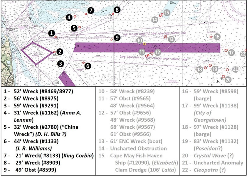
This marine highway consists of a charted and buoyed marine pilot boarding area east of Cape Henlopen, a convergence zone charted as a precautionary area, the east-west Cape Henlopen-Five Fathom Bank (FFB) Traffic Separation Scheme (TSS), northwest-southeast Delaware-Cape Henlopen (DCH) TSS, and separation zones between the inbound and outbound traffic lanes. There’s also a two-way single traffic lane north of the FFB TSS commonly called “Tugboat Alley.” Note: always give way to commercial shipping.
Site 1 is uncharted wreckage found during a 1992 hydrographic survey at coordinates 38°48.009 x 74°58.813. One feature is thought to be a crane. The other feature is about 60’ long and 22’ wide. Divers found a metal wreck oriented east-west with some ribs showing. The image insert in the upper left screenshot on Chart 2 shows the wreck mostly covered with sediment. Best guess is that this was a barge carrying a crane. There is debris scattered on the north side. An east-west line of objects along the south side suggests spilled cargo.
Site 2 is a 56’ unidentified wreck at coordinates 38°46.402 x 74°58.675. The feature is recorded as wooden and metal debris, a concrete block, and a chain. Imaging shows an anomaly in a scour with some small objects at the southwestern corner, as shown by the screenshot on the left side of Chart 2. Whatever it is measures about 30’ across.
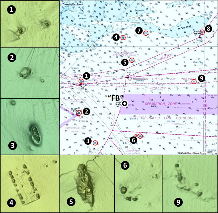
Site 3 is a 59’ unidentified fishing vessel wreck at coordinates 38'44.793 x 78'57.540. When discovered and investigated during the 1993 survey, divers found a single-screw metal wreck with evidence of fiberglass covering the deck rising two to three yards off the bottom. Imagery derived from a 2013 survey shows the vessel in a scour hole sitting upright.
Site 4 was originally characterized as an obstruction with the “appearance of wreckage” and is recorded as the Anna A. Lennen. Although records state that this is a trawler that sank in 1944 after a collision with a tanker, its rectangular feature suggests a sunken barge. The wreckage has a least depth of 35’ and measures about 120’ by 50’. A 2002 survey reported it broken up in sand distributed on the bottom and an image derived from a 2013 survey shows that there are raised objects along each side, perhaps the remains of sidewalls—this wreckage looks like a great spot to try drifting for flounder.
An unidentified wreck lies at Site 5, coordinates 38°49.239 x 74°54.973. Per the shipwreck list in “Gary Gentile’s Popular Dive Guide Series: Shipwrecks of New Jersey” (2002), it is the “China Wreck,” one of several wrecks known by that same nickname. Diver investigation found a cargo of China in a pile about 10’ high and 20’ to 30’ across. The ship is oriented north-south in a scour with portions of the hull protruding up to eight feet from the sediment. This ship was determined to be a British cargo vessel dating from the 1880s, thought to be the D. H. Bills. It measures about 125’ long and 30’ wide. High-definition side-scan sonar images of this wreck are posted on an online Google Map. Do an Internet browser or Facebook search for “Eastern Search & Survey” to access this material.
At Site 6 just east of the Precautionary Area, look for the 44’ wreck of the John R. Williams. Divers found scattered wreckage of this steel-hull barge during a 1993 hydrographic survey. The wreckage is in three main pieces at coordinates 38'45.177 x 74'54.398. Files identify Site 7 as the wreck of the tug King Corbia. The actual name from other sources is King Cobra. The following excerpt describes what’s there: “Yard arm above superstructure. Wreck lies in 11 to 12.1 meters. Tugboat (85’ X 15’) resting on port side. Superstructure intact, deck plating eroded. Oriented E-W, bow towards west. No propeller or anchor seen.” Side-scan and multibeam sonar pictures (top half of Image 1) show the tug intact and upright.

Site 8 marks the wreckage of an unidentified ship, with a portion of the keel embedded in the bottom. Site 9 at coordinates 38°47.843 x 74°50.172 is a 44’ uncharted obstruction near the centerline of the FFB TSS. It’s described as “a debris field (40’ x 15’ x 20’) of boulders 1.8 meters in diameter, 0.9 meters off the bottom. Assumed dumped or lost—not naturally occurring bottom type in this area.” Although in the traffic lane and covering only a small area, the boulders are worth a peek for flounder when passing through the area.
-By Wayne Young
As well as being a regular contributor to FishTalk, Wayne Young is the author of multiple books detailing wrecks and fishing reefs in the Chesapeake Bay, Delaware Bay, and beyond. All are available at Amazon.com, and you can find his Facebook page at “Chesapeake Bay Fishing Reefs.”