Among the Northern Neck, VA, tributaries which have extensive oyster farming operations is the Yeocomico River, a small tributary to the Potomac River near its junction with the Bay. This practice has been controversial, notably to those owners of shorefront properties who prefer not to have commercial oyster leased grounds immediately offshore of their waterfronts. On the other hand, water filtering by farmed oysters makes a local contribution to water quality in addition to the economic benefits associated with successful farming operations.
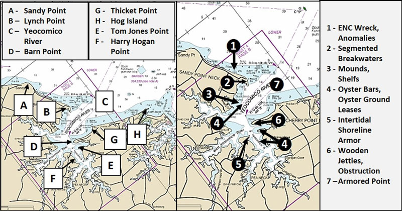
Boating, crabbing, and fishing are allowed over these leased areas, a number of which are highlighted for general awareness and for such fishing opportunities as each might afford. Recreational fishermen should extend a courtesy to holders of leased grounds by not operating or fishing over the leases while watermen are present working the gear. With respect to bottom structure, cages must rise no more than a foot off the bottom. Floats are often attached to each cage and cages are typically in close proximity to each other. So, fishing over or casting into locations with cages has a high risk of snagging gear. Fishing around the edge of leased grounds or using topwater lures are options that can reduce snags.
About 1000 yards northwest of Lynch Point, generally marked as Site 1 on Chart 1, is an Electronic Navigation Chart (ENC) wreck. The feature is charted as “PA”, or position approximate, at coordinates 38’03.125 x 76’31.471. There’s also an uncharted elongated feature about 1500 yards from the point at coordinates 38’03.373 x 76’31.661. Maybe it’s natural and maybe not. A second anomaly is an elongated dark shadow at coordinates 38’03.034 x 76’31.303. It could be natural, a wreck, or some other obstruction. And a third anomaly is by appearance a massive dump of concrete slabs and rubble. The main pile is at coordinates 38’02.921 x 76’31.349. The shapes of individual objects are clearly visible just below the surface in a 2015 Google Earth satellite image (Top right Image 1). Several large slabs or blocks are also visible in the image at 38’02.930 x 76’31.353. The entire feature appears to extend farther offshore based on underwater shadows, the outer extent of which is at coordinates 38’02.930 x 76’31.342. The main pile is just off the beach. Given the location and configuration, best guess is that this was a homemade shoreline protection (or fish attracting?) project, the professionally installed rock armor along the shoreline notwithstanding. Although whatever material is at these spots is uncertain, they all are obstructions that certainly should attract sportfish.
About 400 yards northwest of Lynch Point is another anomaly about 50 to 60 yards off the beach at coordinates 38’02.700 x 76’32.256. Two adjacent somewhat oval objects that by appearance resemble ballast piles are just below the surface. Lynch Point to the south, Site 2, is protected by multiple rock structures. At the northwest end of the point, shoreline armor extends out to form a groin. Then, a series of five segmented breakwaters have stabilized a long, narrow spit that extends into and marks the upriver side of the entrance into the Yeocomico River. The two at the southeastern end wrap around the spit and are connected by a wooden bulkhead.
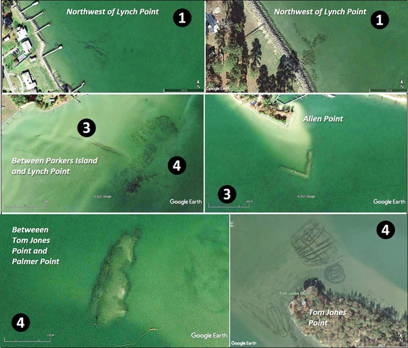
Inside the Yeocomico River, look for a variety of natural and artificial structures. Site 3 on Chart 2 is a general marker for natural and possibly manmade features off the southeast face of Sandy Point Neck and also in the West Wicomico River off Allen Point. The most prominent feature is a narrow, elongated submerged mound where there is a charted dashed black line. The Digital Elevation Models (DEM) Color Shaded Relief image from the National Oceanic and Atmospheric Administration’s (NOAA) Bathymetric Data Viewer (BDV) shows this feature measures about 200 yards long and runs southeast from the shoreline. There’s a line of three small anomalies shown on the chart which may be part of the same feature.
The earliest historic image accessible using Goggle Earth dates to 1994 in which the feature looks about the same as in 2015. By appearance and orientation, this feature suggests an old submerged unimproved road out to the oyster grounds, but it could certainly be of natural origin since there is an underwater shelf or point about 200 yards long southeast. This point is outlined by a charted 10-foot contour line.
The feature off Allen Point is charted as a breakwater. It’s shaped like the letter “V” pointing towards the northeast along the edge of the underwater spit (2 on the charts, center right on Image 1). There’s decent water on the channel side. The structure is massive and just below the surface. Each arm is about 50 yards long. Composition is not given, but it has the physical form of a rock breakwater, and yet another example of failed shoreline protection. It is a definite casting destination.
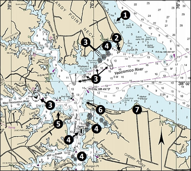
Site 4 on Chart 2 is a general marker for constructed oyster bars and multiple active oyster ground leases using a 2015 satellite image. The constructed oyster bar in the South Yeocomico River is huge, about 150 yards long by 40 yards wide. It’s charted and highlighted by a dashed-line box. Icons in the form of a cluster of small circles in the illustration show the approximate locations of the oyster ground leases.
Receding shorelines formerly protected by rock armor but since compromised, such as found off Allen Point, are a type of feature that is high on my armchair scouting list especially for catching stripers in the shallows. Many of these older structures weren’t anchored at the ends to prevent flanking as waves eroded adjacent unprotected shorelines. Other structures were too low or were subjected to episodic storm events and were overtopped, resulting in erosion of sediments that supported the armor, causing it to collapse. In some cases, foundation sediments weren’t strong enough and the structures simply settled lower in the water resulting in their submergence. Or, the structures were composed of unsuitable materials. A relative rise in sea level, that is, the combined effects of rising water level and subsidence, exacerbates weaknesses in design and construction.
When these factors are not effectively addressed, thanks for the fishing spot!
Site 5 in the Yeocomico at the northwest corner of Mondays Neck marks a long intertidal breakwater that appears to align with an earlier shoreline. With the existing shoreline armored with a modern rock structure, the older feature helps dissipate wave energy. Across the water to the northeast is Barn Point. The north side is well protected by stone armor which wraps around the southwest end of the point where Site 6 marks old wooden jetties. Based on how sand is trapped by the jetties, the flood current rolls along the northwest tip and a less strong ebb flows along the southeast side. The casting target zone is on both sides of the tip when current is running. There is a charted obstruction off the end of the point, but the feature isn’t recorded in AWOIS. Several satellite images show an object that could be a snag. Approximate coordinates are 38’01.605 x 76’32.206. Whether or not this object is fixed in position or temporarily grounded can’t be determined from the images.
Thicket Point (Site 7) marks the northeast side of the Yeocomico River entrance. The point is shaped like an arrowhead, heavily armored with rock, and points towards the northwest. The Yeocomico side between Barn Point and Thicket Point forms Thicket Point Bay which has a natural shoreline as it approaches the point. Checking satellite images, strong, very turbid tidal rips trailing off to the southwest from the point were visible. This suggests that sediment is picked up from the unprotected shoreline in the bay during ebbs. Dirty water doesn’t favor fishing, however, a tidal rip creates a temporary boundary that channels the flow of current and bait and predators may forage along the clear side. So, it’s worth a few casts when the flood current is running and clearer water is moving upriver.
The shoreline on the Potomac side of the point runs towards the east-southeast past waterfront homes protected by stone armor and bulkheads, and then becomes a natural shoreline all the way to Hog Island on the north side of Judith Sound — where massive shoreline changes have occurred. But, that’s a story for another day.
Editor's Note: For more intel on the immediate area see Yeocomico to Coan Rivers: Fishing Opportunities Abound.
- By Wayne Young. As well as being a regular contributor to FishTalk, Wayne Young is the author of multiple books detailing wrecks and fishing reefs in the Chesapeake Bay, Delaware Bay, and beyond. All are available at Amazon.com, and you can find his Facebook page at Chesapeake Bay Fishing Reefs.