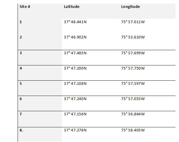
It’s tough to thoroughly scout fishing structure in advance when the most recent chart that covers a prospective fishing destination is based on survey data from the 1950s, and in some cases, before the second World War. That was, and in some cases still is, the cartographic status for parts of the Chesapeake Bay and its tributaries. But that situation is changing as results of hydrographic surveys conducted with modern technology are made available to the public in processed formats as well as data files. But a caveat here: Hydrographic surveys with modern survey equipment that produce data which can be processed as three dimensional-like color shaded contours has been going on piecemeal for two decades. So, the visual bathymetric displays made from data vary. One of the more intriguing and remarkable features we can see thanks to surveys is a natural formation tagged here as the “Watts This” sediment flow anomaly, marked as Site 1 on Chart 1, between Watts and Tangier Islands.
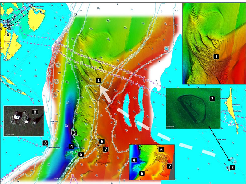
The feature in question looks like a mile-long lava flow over an edge into a valley. But, no volcanoes here! This is new data, and coastal geologists haven’t weighed in on it. Our theory is that this subsurface spit consists of eroded sediment from the southeast where Little Watts Island was located. This island was exposed to physical energy from the south and southwest. It eroded away leaving the drowned ruins of rock armor from shore protection works, a lighthouse, and a lightkeeper’s house. Today it’s charted as Watts Island Rocks (Site 2 insert on Chart 1, Image 1).
Feature orientation and configuration suggest that as the rocks settled and the shoreline eroded, sediment was transported towards the northwest, across the flats, and over the edge into the deepwater riverbed trench that was the ancient Nanticoke River valley. Once over the edge, the sediment transport path abruptly curves to the north-northeast. While we don’t know why the rock armor which ringed the island settled, probable causes are scouring along the foot from wave energy and settling due to unsuitable or marginal bottom conditions which lacked the strength to support the weight over the long term. These are the changed conditions we look for when scouting shorelines and near-shore areas for failed shoreline protection structures that become unintentional but fish-attracting artificial reefs.
The spit slopes downward from the flats where it has a least depth which varies between 20’ and 50’ before dropping off to 60’ into the ancient riverbed (Image 1). The ridges towards the eastern end have the appearance of fine-grain sediment waves. The higher relief middle and lower slope steep ridges with vertical relief up to 10’ are more granular because of how they stack up. Fine-grained sediment scoured by bottom currents was deposited at the northern end of the spit in the middle of the trench. These are less well-defined deposits which are characteristic of fine-grain and soft sediment deposits. Currents flowing across the feature’s extremely ragged surface cause subsurface turbulence. Try deepwater trolling here, and for flounder on the flats and over the edge.
How the spit took its form is a good question. Chesapeake Bay has complicated water flow. Even though the estuary has a net overall discharge because of the huge volume of freshwater inflow, scour is frequently found on the northern side of structures way up the Bay even beyond the Chesapeake Bay Bridge. This is the result of salt wedge flow dynamics. The sediment transport pattern of the Watts This feature towards the north is consistent with salt wedge hydrodynamics, including the dominance of flood current moving north along the bottom. The freshwater inflow from DelMarVa rivers is a small percentage of the overall freshwater that discharges from the Bay’s tributary rivers. So, the incoming (flood) tidal flow isn’t offset as much as on the west side of the Bay.
Salt wedge? Normally in an estuary, salinity increases vertically with depth and horizontally when moving from upstream to downstream towards saltwater. Vertical change in salinity occurs because density increases with salinity, causing saltier water to sink towards the bottom. Fresher, less dense water rises towards the surface. This creates vertical layers that form a wedge with the leading saltier foot along the bottom referred to as the “salt front.” Thus, the denser saltier water being pushed up the Bay by incoming tidal action is along the bottom and the less dense brackish water is over top of the wedge. This is why sediment is carried up-Bay along the bottom and why a scoured jigging hole is often on the north side of structure.
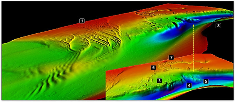
Immediately south of the previously described spit there is a hard drowned bluff (Site 3) that formed the east side of the Nanticoke River valley in geologic times. This north-south feature is about 2700 yards long, has an extremely ragged edge, and drops off from a least depth of 45’ into the deepest hole in the trench at 120’. The deep hole is at the base because the steep-sided hard structure, probably rock, was a permanent barrier that extended well below the bottom sediment. Back when this was a riverbed before it transitioned to an estuary, flowing water striking the hard barrier increased velocity and turbulence that then reached down and scoured deep trenches in the bottom along the base.
A notch (Site 4) at the south end of the former bluff has depths to 101’. It separates the bluff from a 675 yard-long, 200-yard-wide subsurface hard point (Site 5). This formation is very deep, 65’ to 85’, and extremely rugged. Orientation is east-northeast to southwest. Although it’s exceedingly deep, it has two sections separated by a 75-yard-wide cut with a 10’ drop. This feature obstructs and thus interacts with bottom currents. Flood currents spill through the cut and hit the south end of the bluff. The net effect is a lot of subsurface turbulence. Try bottom fishing the top of the edge. Also try deepwater trolling the entire length of the formations.
Northeast of the notch is the opening of a slough through the edge. The entrance is oriented east-west and has a least depth of 42’. The slough then makes an abrupt 90-degree turn to the south and narrows. The eastern end of the entrance is choked with a dense, worn-down field of remnant oyster reef (Site 6). A large approximately circular mound (Site 7) with a diameter of 135 yards and a least depth of 16’ is on the east side.
Tangier Island Light across the Sound is at the southern end of the long-drowned ancient peninsula that includes Tangier Island, it’s southernmost unsubmerged topographic high. The light (Site 8) sits on a shelf on the west side of a submerged hard headland. Depths drop from around three feet at the light to 86’ immediately to the southeast. The fishing structure consists of three platforms. One is the actual light which sits on a platform on top of concrete pilings. There’s a second historic platform nearby which is the main fishing spot.
After the wrought-iron steel piles of the former screwpile lighthouse were damaged by severe ice floes during the winter of 1917-18, the piles were encased in a concrete caisson block with four-foot-thick sidewalls. A thousand tons of riprap was placed around the perimeter for scour and ice protection. Today, the caisson is below the surface. Rocks extend well outside the perimeter of the skeletal steel tower which was abandoned in place. Cast to the rocks. Also work the sharp drop-off around the southeast side of the light.
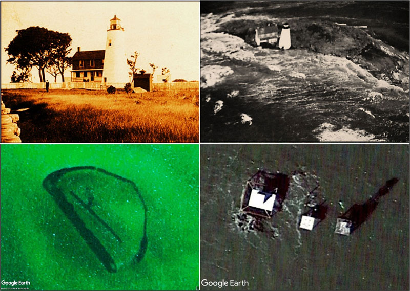
There certainly are a lot of rocks around old Tangier Island Light. But Watts Island Rocks, the ruins noted earlier immediately south of Watts Island, has them beat in sheer magnitude. They are the remains of an 1833 lighthouse which was a classic conical masonry structure (top left insert). A lighthouse keepers’ house was alongside. They were on Little Watts Island, a low-lying sediment bank that was ringed with riprap, all now submerged. The light was deactivated in 1923. The island, including the light structure and keepers house, was sold to a private party. Thereafter it became a hermit’s domain. The hermit at one point went to Baltimore, got married, and brought back Mrs. hermit. Eventually the light and keepers’ house were abandoned and overcome by the Bay during a 1944 winter storm.
Navigational chart symbology warns us about the obstructions but doesn’t convey the full extent and configuration of the rocks and masonry which comprise this danger to navigation and fishing hotspot. It looks like a submerged atoll protected by a barrier reef, all subsurface, shaped like the letter “D” rotated 45 degrees to the left. The fixed light warning of this danger is 300 yards southwest of the south end of the ring of riprap. Approach this spot very carefully, the rocks are close to the surface. This spot is a reminder that much of what we fish poses hazards to boats.
The 2025 hydrographic survey results give us a renewed appreciation for the structural diversity of Tangier Sound entrance and the circulation connection with Pocomoke Sound. There’s structure here and multiple species to prospect for, whatever fishing gear and tactics you prefer.
-By Wayne Young
As well as being a regular contributor to FishTalk, Wayne Young is the author of multiple books detailing wrecks and fishing reefs in the Chesapeake Bay, Delaware Bay, and beyond. All are available at Amazon.com, and you can find his Facebook page at “Chesapeake Bay Fishing Reefs.”