The Magothy River watershed is like a mini Chesapeake Bay, and fishing here is a microcosm of Chesapeake Bay fishing. The river has a main body fed by tributaries with tidal influx and some fringe marshes surrounded by an upland area watershed. It faces similar pressures from development and runoff that discharges sediment and pollutants and degrades water quality. Indeed, 22-percent of the watershed is paved and over 50-percent of the land is in residential development. So runoff is a major concern. Since 1949, the Magothy River Association (MRA) has worked to safeguard and improve the environmental quality of this Bay tributary through citizen action.
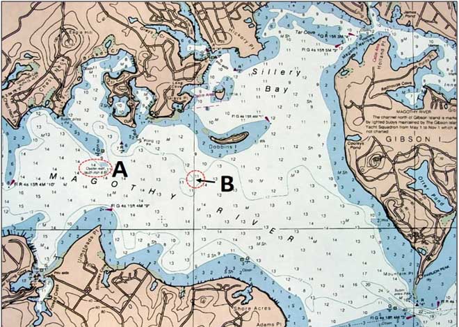
Back in 2004, the MRA sponsored an artificial reef project with assistance and support from the Maryland Environmental Service (MES), technical and permit support from the Maryland Department of Natural Resources, assistance from South Ferry Point and Cypress Marine, and grants. The objectives were to restore vertical oyster reef structure and to provide recreational fishing opportunities that would encourage recreational fishing and conservation. It was my good fortune to direct the project for MES, and also serve as one of the volunteers from MES, MRA, Ann Arundel Community College, and a freshman biology class from Annandale High School, Virginia, who built some of the Reef Balls. Three reefs were established. Two are combined oyster restoration and fishing reefs at locations A and B in the chart. The third (not shown) was placed by the MRA dive team using a float and sink deployment technique developed by the Reef Ball Foundation. It is a smaller reef that was intended for monitoring marine growth. The area of the southern shoreline below location B out through the entrance is good fishing ground throughout most of the year. When the Bay is too rough to fish, try dipping a worm in the Magothy.
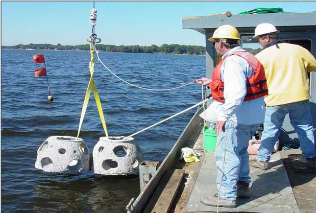
Two reef ball sizes were used. Each module ranged from two and a half to three feet wide. They rise to a maximum of three feet off the bottom. The modules were put in by crane from a work boat. Clusters were placed on the bottom off each side of the boat in proximity to a marker buoy. The reef off Rock Point covers an area about 100- to 120-feet wide. Charted water depths at this reef are nine to 11 feet.
Reef Balls on the Fishfinder
Looking at saved sonar screen images on a large screen at home often reveals more detail than when looking at the same image on a small sonar screen while bouncing around in chop. So when Nick Garrott (of BOE Marine) shared a very busy Humminbird MEGA side-scan sonar image of marauding striped bass attacking bait at reef balls in the Magothy River, it was time for a closer look. What was really in the picture?
Nick was checking out a high definition side-scan sonar unit when passing by the Rock Point reef. The image is very well defined. On very close inspection, it’s even possible to discern a fuzzy layer of marine growth on the reef balls. With the approximate reef site size as a reference, this makes the bait ball line in Nick’s image perhaps 200 feet long.
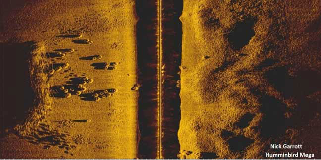
Side-scan sonar looking across a target creates a shadow, clearly visible behind the reef balls and fish. On a shallow flat, the effect is an elongated dark spot on the bottom. But what the image shows going on with the fish is remarkable and such detail would be easy to miss while underway, without having already internalized a mental image of what fish and structure looks like on side-scan sonar.
Learning how to interpret the newer high-definition scanner images is a work in progress, and using side-scan, down-looking, and traditional sonar images in combination provides a more complete means to put us on fish and assess what is going on below. Also, while not conclusive, the smaller shadows in the image suggest larger fish moving through and around the reef balls towards the bait. My read is that these smaller shadows are not from structure and are consistent with additional images of fish shadows. I’ll be looking for similar patterns on my side-scan sonar during future fishing trips.
Considering how reef balls and fish appear on different types of down-looking sonar also offers some insight. Reviewing the basics, fish arches, the inverted “V” marks on a traditional fishfinder, tell us the transducer just passed over a fish. The bigger the arch, the bigger the fish. The more arches, the more fish. Where there's a gaggle of arches, it’s time to start bouncing jigs off the bottom or swimming them through suspended fish. Maybe the fish will bite, and maybe not.
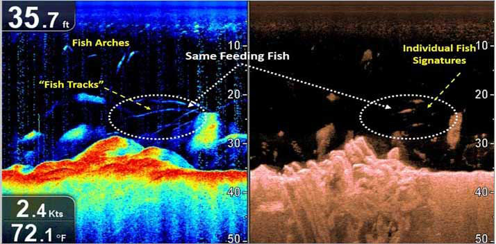
The newer generation sonars with “scanning” or “imaging” features show fish a bit differently, so we have to relearn what to look for in each image. An example can be seen in this side-by-side down-looking screen shot showing a CHIRP fishfinder and a high-definition scanning image taken at the Holland Point Fish Haven. These two images of the same structure, bait, and predators, taken at the same time, show how each is displayed differently and offers some insight when looking at a side-scanning display.
Whatever type of fishfinder you may have on your boat, one thing is for sure: locate these reef balls, and there’s a very good chance you’ll also locate some fish – maybe lots of fish.
For more information about fishing reefs, artificial reef layouts, reef ball sites, and volunteer reef restoration projects, see "Bridges Under Troubled Waters: Upper Chesapeake and Tidal Potomac Fishing Reefs" (2018), available at Amazon.com.
Understanding Fishfinder Frequency
There’s a lot of confusion and misinformation about fishfinder frequencies out there, and to better understand what you’re seeing on-screen a basic explanation is in order.
The much higher sonar frequency used by scanners and imagers (400-plus kHz) enhanced detail because high-frequency sonar waves are much more sensitive than the lower frequency waves (240 kHz and lower) used by traditional fishfinders. The down-side is weaker depth-penetration, which explains why even the best scanners are usually limited to 600 or so feet of range in ideal conditions. Here’s an easy way to picture the difference between higher and lower frequency sonar waves: think of them like the waves in a pond. If you toss a pebble into the pond, it sends out a series of small, tight, fast-moving waves which are easily reflected back. If they strike a mere spring of weed or a leaf floating on the water, they bounce off of it and provide a tiny return wave. These waves are like those produced by high-frequency sonar transmissions.
Now, throw a boulder into the pond. It makes much larger, slower, wider-spaced waves than the pebble did. Those large waves will go a lot farther than the pebble’s ripples – but they’ll also roll right over small items like leaves and twigs, instead of being reflected back. These are your lower frequency waves.
The net result? Think of your traditional 200/50 kHz fishfinder as best for taking an X-ray that sees for long distances, while your higher frequency 455/800 kHz scanners take a short-range image more like an MRI. But there’s a catch. Fish and structure reflect sonar pings differently at different frequencies. In fact, fish, rays, sharks, and all kinds of critters of different species (with different size and shape air bladders, different densities, and different habits and habitat) may each provide returns of different intensities at different frequencies. That’s why in some cases a traditional fishfinder provides better hard fish returns than a scanner, even as that scanner might provide far better returns on the structure those very same fish are swimming around.
To learn about other reefs in the Bay, see the listings and links at Chesapeake Bay Fishing Reefs.
Sign up here to get the weekly FishTalk Chesapeake Bay and Mid-Atlantic fishing reports in your email inbox, every Friday by noon.