Presented by Sirius XM Marine

Ronald Reagan was president, GPS didn’t exist outside of the military, and recreational boaters were running around with two-stroke outboards that were about as reliable as the weatherman when I enjoyed my first true offshore adventure in a small outboard-powered boat. We were probably a little bit safer than we would have been cruising down the highway in a Ford Pinto, but heading for a spot like Baltimore Canyon was mostly reserved for diesel inboard boats, guys too young to know better, and crazies.
Okay, maybe I’m exaggerating a little. But only a little. Back then going offshore meant hitching a ride on a big boat or recognizing that you were taking a significant risk, and doing so on a 20-something-footer with a single outboard engine was considered foolhardy at best. Then we got four-strokes, boat manufacturers got better and better at building boats that didn’t break, and modern navigational systems hit the scene. More and more recreational anglers began making the voyage to the edge of the Continental Shelf, which meant there were usually more boats around just in case anything did go wrong. The level of danger dropped significantly. But running 50-plus miles from the inlet is still, even today, a big endeavor that entails risk. If you plan on running your own boat out there you need to think long and hard about just what safety investments you’ll make. These three items should top your list.
EPIRB, PLBs, and Satellite Messengers
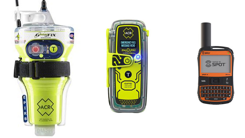
EPIRBS (emergency position indicating radio beacons) are the best panic button around for boaters, period. They’re uber-reliable, communicate directly with search-and-rescue personnel, and are designed to work even when floating in the ocean. Same goes for PLBs (personal locator beacons), more or less. The main difference between the two is that an EPIRB is registered with and stays with a specific boat, while a PLB is carried by an individual. EPIRBS do last longer, however, with a minimum 48-hour runtime versus 24 hours for a PLB. Note that in either case it’s best to get one with an internal GPS. Units that don’t have GPS can get rescuers into the area, but those with it can provide your exact position. Also note that all EPIRBS float, and while most PLBs do, some do not.
Satellite messengers are great, but they don’t send their signals directly to SAR personnel. Instead, if you hit the SOS button the alert goes to an emergency response center, which then communicates with the authorities. In practice the system has performed exceptionally well, but the extra step in communications could potentially produce a delay. On the flip side of the coin most allow for two-way communications and in an emergency situation that can be invaluable. We do note, however, that some messengers work by pairing with your phone. Bluetooth can be finicky at times and you don’t want to wait for pairing while you’re standing on the deck of a sinking boat, much less when you’re treading water. Also note that while satellite messengers enjoy the advantage of being useful communications devices even in non-emergency situations, they also require a monthly subscription fee.
SiriusXM Satellite Weather
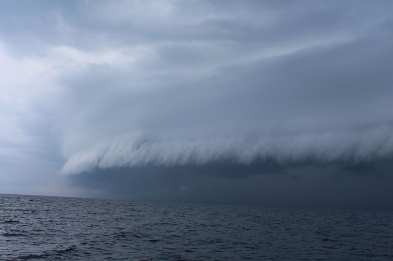
SiriusXM Marine is a FishTalk supporter and we thank them for it, but that alone doesn’t earn them a spot in this article. What does prove its safety value, however, is multiple firsthand experiences on the ocean. Remember the crack we made earlier about the reliability of the weatherman? It’s well-deserved, and there isn’t a single pair of eyes reading these words right now that hasn’t read a weather forecast which turned out to be ridiculously (and maybe dangerously) wrong. With SiriusXM weather aboard, however, you can overlay near-real-time weather right on your chartplotter screen. You can watch the pop-up thunderstorms develop, see where the lightning strikes are, and monitor the direction and speed of those storms.
I’ve had multiple personal experiences when I was offshore on my old Glacier Bay, staring at a wall of black on the horizon even though the weatherman neglected to mention any possibility of thunderstorms. One look at SiriusXM weather overlaid on the chartplotter told me which way to run to get out of the line of fire, and how long I had to do it. I can remember multiple occasions when I was able to dodge storms completely, and one — with my 10-year-old boys aboard — when it told me to head for home early and I pulled up to the boat ramp just as we saw the first bolts of lightning.
Active DSC VHF
Pay special attention to the word “active,” above. Every VHF unit built since 1999 has Digital Selective Calling (DSC) functionality. With DSC when you flip up the red lid on the face of the radio and press the panic button the Coast Guard knows you need assistance, knows your exact location, and knows what type and size boat you have. HOWEVER, DSC only works if you’ve taken the steps to make it active, and according to the latest statistics over three-quarters of the DSC radios out there aren’t.
That. Is. Tragic. If you haven’t already done so you can boost your safety margin no matter where you do your boating, right now, by going through this process. And it will take less than half an hour. First, go to the BoatUS MMSI webpage and get an MMSI number. (It’s free for BoatUS members, $25 for non-members). This is a nine-digit number that will be assigned to your radio. Then go to your boat, turn on the VHF, and follow the radio manufacturer’s instructions to plug in the MMSI. It’s ridiculously easy and a quick Google search on your cell phone will tell you how to do it while you’re standing at the helm. If your VHF has an internal GPS (most except the very basic models do these days), you’re done. If not, you need to connect your chartplotter’s data-out wire with the VHF’s data-in wire. Again, a quick Google search makes this incredibly easy (I just timed myself and it took 15 seconds to find instructions to link a Garmin EchoMap and an Icom VHF). No excuses, people — anyone reading this who has inactive DSC on their boat should make it happen before they leave the dock even one more time.
Are there other measures you could take to be even safer at sea? Of course. Life rafts will be worth considering for some, offshore fishing on the buddy system is always a good idea, and a healthy dose of common sense when making the go/no-go decision is critical. But these three things — satellite-based panic buttons, SiriusXM weather, and DSC VHF — will turn that Pinto into a Volvo.