The Northern Neck of Virginia borders the Potomac River, but natural forces acting on the shoreline and inlets create conditions just like those found along the Eastern Shore’s oceanic coastlines and barrier islands. Receding lands have resulted in submerged sod banks, submerged islands, ruins, and remnants of failed shore protection structures that jut out into the longshore current flow. Additionally, tributary waters are home to substantial oyster farms with subsurface cages. Many of these features are spots to prospect for striped bass when they’re feeding shallow.
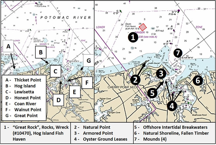
Site 1 on Chart 1 is a general marker for the northeastern approach to the Yeocomico River mouth north of Hog Island and the Hog Island Fish Haven. Today, Hog Island is the high ground at the end of a narrow peninsula rather than an island. North northwest of the peninsula’s tip about 1850 yards is a natural rock formation at coordinates 38’01.701 x 76’28.585. Known locally as “Great Rock” this formation has several high points. The feature rises as much as 10 feet above the surrounding bottom and is a well-known local fishing destination.
Northeast of Great Rock about 2000 yards is the southwest corner of the Potomac River Fisheries Commission’s (PRFC) Hog Island Fish Haven. The fish haven contains a substantial deposit of Wilson Bridge concrete demolition materials. Immediately southwest of the fish haven is an area of hard, rugged rock bottom with a rise of about five feet and which is about 400 yards long centered at coordinates 38’01.934 x 76’27.427. The ridge is oriented north northeast to south southeast. A six-foot wreck, Record Number 10470 in the Coast Survey’s Automated Wreck and Obstruction Information System (AWOIS), is a 39-foot cabin cruiser that sank in 1968 about 600 yards southeast of the fish haven’s southeast corner at approximate coordinates 38’01.834 x 76’26.969.
Hog Island, Site 2, was a barrier island that extended across the north side of Judith Sound in 1868. It was separated from the mainland by a short cut known as Judith’s Creek which led into Judith’s Sound on the west side. With erosion of the eastern end of the island, the sound has transformed into a shallow bay, probably filled in with the eroded sediment. However, some of the drowned eastern end is submerged sod bank.
The western side of the Hog Island remnant which juts out to the north is connected to the mainland by a wide beach that formed across the entrance to the creek. A little cut along the southwest corner of the remnant is probably Judith’s Creek. A jagged sod edge is on the Potomac side of the feature. Comparing satellite images from 2015 and 2021, it is apparent that the river side of the remnant has eroded and receded about 50 feet. A sandy beach that was on the north side was washed over Hog Island exposing the sod edge. When you see sand in the brush and trees, that’s the result of overwash from major storms which scoured the sand and transported it into the uplands where it was deposited.
The thin peninsula that ran east from the southeast corner has breached, leaving a little islet. Eventually, this too will disappear. The flood current follows the edge to the tip and runs towards the northwest. An ebb should flow from this little point towards the northeast. Try casting to this little point on both ebb and flood currents. Also prospect along the north side and off the eastern tip from the river side.
Travis Point as charted applies to the entire neck and not just the north point. The Lewisetta waterfront on the eastern end of the point is lined with docks, some of which have adjacent pier ruins. Site 3 marks the south corner of Travis Point where rock armor extends around the corner along with a series of wooden jetties. A series of wooden jetties with loose rocks placed along the rear to middle sections project out from the shoreline.
Site 4 is a general marker for commercial oyster reefs and oyster farms on leased oyster grounds in the northern half of the Coan River, the Glebe, and the mouth of Kingscote Creek. Most of the leased grounds have multiple spots where there are bags or cages full of oysters.
Site 5 is an intertidal breakwater that runs from Cowarts Point north northeast along the face of the neck. By appearance, this may have been a protective structure for an earlier shoreline. Try casting to the closed end at Cowarts Point and also the open north end. There is a circular anomaly in the shallows at coordinates 37’59.809 x 76’28.274. The northeast tip of the neck has several features that jut out from the shoreline. The water is very shallow, but might be worth a cast or two with topwater lures.
Great Point, Site 6, marks the southeast side of the Coan River mouth (the entrance channel is on the Hog Island side). The shoreline along the northeast face of the point is littered with fallen timber. The area immediately offshore is charted as foul. Satellite images show submerged fallen timber between the northeast side and Private Marker “1A” at coordinates 37’59.242 x 76’26.584. Water depths are rather shallow, but offshore submerged timber often attracts speckled trout and stripers.
Moving northwest of the point 600 yards brings us to one of three elongated mounds shown by the BDV “DEM” Color Shaded relief image for this area (Chart 2). Private marker “1A” is at the southeast end of the mound which is shown as about 200 yards in length. All are marked in general as Site 7.
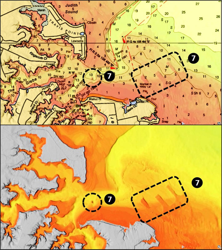
When using shaded relief images or chasing shadows in satellite images, confirming data is helpful insofar as available because of the potential for artifacts and shadows in images that can be misleading. In this case, a Google Earth satellite image shows a line of intense underwater shadows where the BDV “DEM” image shows the first mound, which is the shallowest of the three. Water clarity and surface conditions obscured this feature in satellite images viewed from other resources. Best guess is that there are three low-profile mounds as indicated. There is another mound, also generally marked as Site 7, located 1600 yards west northwest of Great Point. This pronounced circular feature, also detected using the BDV “DEM” image, is at coordinates 37’59.456 x 76’27.647. Although the mound isn’t charted, it is just to the southwest of a short bubble in the 10-foot contour line.
Northern Neck tributaries offer sheltered locations to fish when conditions are unfavorable for small recreational craft on the Potomac or the Chesapeake Bay. The Glebe, Coan River, and Yeocomico River entrance have enough features to fill up more than a day of prospecting.
Stay tuned for next month, when we’ll take a detailed look inside the Yeocomico River itself.
- By Wayne Young. As well as being a regular contributor to FishTalk, Wayne Young is the author of multiple books detailing wrecks and fishing reefs in the Chesapeake Bay, Delaware Bay, and beyond. All are available at Amazon.com, and you can find his Facebook page at Chesapeake Bay Fishing Reefs.