After buying a new boat back in 2008, an immediate task as a new Northern Virginia boater was learning the local tidal Potomac River. Fortunately, “Ken Penrod’s Tidal Potomac River Fishing Bible” (1995) was still in print. It was and still is a great resource and served as inspiration for my “This Is Potomac River” (2023). Although I’d always been a saltwater fisherman I wanted to learn how and where to fish for largemouth bass, and his book was the ticket. Included were details about Mattawoman Creek, a popular fishing destination with a wide range of conditions and features that functionally resembles the Chesapeake Bay estuary in miniature.
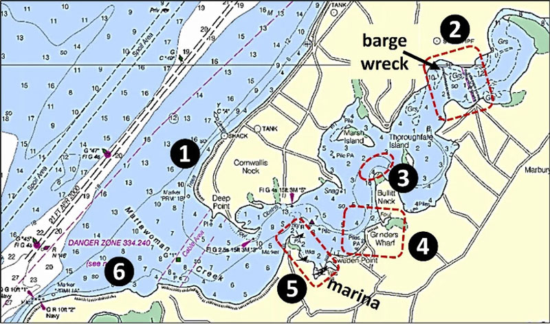
Lands on both sides of the creek entrance and along the north shore are Naval Support Facility Indian Head property. The shoreline is accessible for fishing unless otherwise posted, but landings by the general public are not authorized. Also, much of the south shore east of the naval property is either a state park or environmental conservation area. Take special note that the western end of Mattawoman Creek is a charted danger zone. Cornwallis Neck is occupied by the Naval Surface Warfare Center Indian Head military reservation. Navy use of the property dates from 1890 and the facility was a proving ground during World War One. Thus, there is the potential for unexploded ordnance.
Scouting just north of the creek entrance, the Potomac River shoreline along Cornwallis Neck south of Indian Head has been extensively armored with substantial rock segmented breakwaters on both sides of Site 1. There are little coves at each of the short breaks between segments, any of which can attract bait and predators. The breakwaters extend part way around the southwest corner of the neck into the north side of the Mattawoman Creek entrance. Inside the creek, there are plenty of natural features and multiple species to target.
There are extensive grass beds inside the creek. Some of the prime fishing grounds include the waters around Marsh and Thoroughfare Islands and around smaller islands further up the creek. All of the shorelines offer a variety of habitat including gravel, fallen trees, wrecks, and ruins. Structural conditions have changed over the past decade particularly with respect to manmade structures that are today’s deteriorated ruins and remnants.
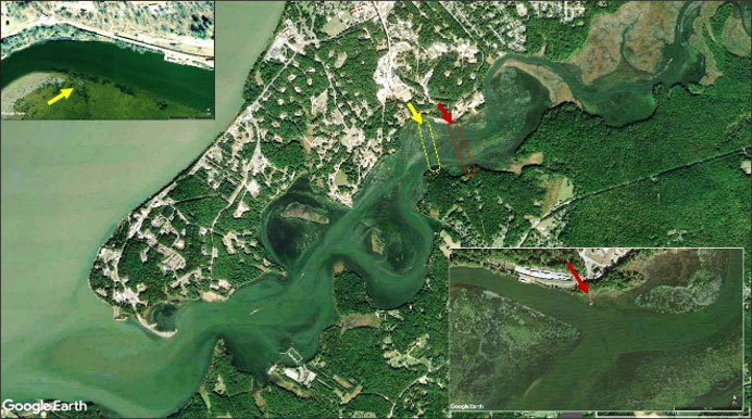
Artificial structure to look for includes three broken lines of piling that extend between the north and south shores towards the back end of the creek shown generally as Site 2. Ken Penrod said in his book that these pilings are the remains of footbridges between the south and north shores for naval facility walking commuters. A causeway with an opening at the northern channel first appeared on nautical charts in 1936.
Each line consisted of a double row of pilings. Since I first went there 15 years ago most of the pilings have disappeared below the surface, so be very careful when approaching in a boat. The westernmost line of pilings ends at what appears to be a barge frame and crossmembers at the southern edge of the northern channel. It’s typically covered with vegetation. The easternmost line of pilings connected to a footbridge on the north shore which rested on a concrete pier which is still there. Twisted remains of the footbridge lie mostly submerged between it and the shoreline. The shoreline behind the pier has a concrete bulkhead that extends northwest to within about 100’ of a concrete landing. This is an old barge landing that was used for offloading coal.
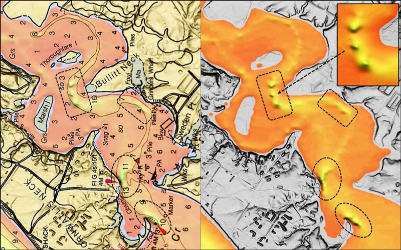
Site 3 marks three anomalies that present as holes off the north point of Bullitt Neck as shown by Chart 2 images with a see-through raster chart overlay. Each of the deep-water areas shown provides good fishing opportunities. Having three separate holes in close proximity to each other at this location suggests that they were excavated for sand and gravel at some time in the past.
Site 4 is off a spot charted as Grinders Wharf. Frederick Tilip in his 1978 epic “This Was Potomac River” reports that there were multiple commercial wharfs in this cove that supported the fishing industry, and that Grinders Wharf had a lot of activity. It was also the landing for a brick manufacturing plant. The remains of the old piers and wreckage are submerged in the area shown. Although good fishing grounds, caution is the watchword when moving through the area as none of the obstructions are marked.
Site 5 marks the water and shoreline area between Rum Point to the north and Sweden Point Marina at Smallwood State Park, where there is a nice boat ramp. The marina docks are all fishable. There are old wrecks charted along the shoreline between the marina and Rum Point, all submerged. About a decade ago I found an aerial photograph showing the frames of wrecks about halfway up this shoreline. The barge frames were still visible just below the surface in a satellite image viewed in early 2021. Although deteriorated and low profile, they nevertheless provide good fishing structure. The barges are located at the south end of a cove just west of the point where the shoreline falls off towards the west.
Around Rum Point to the west is another prime fishing shoreline shown as Site 6 for general reference. Running from Deep Point west about halfway to the entrance is natural shoreline. From there, much of the shoreline has been armored with rock. There are some breaks and pocket beaches. The point at the southern entrance is protected by a series of segmented breakwaters. Again, this is part of the naval facility. Observe any restricted access signs or notices.
This wonderful mix of structure, deep water, shallows, and grass beds make Mattawoman a Chesapeake Bay in miniature. And like those found on the Bay, are all waiting for us to come fish them.
As well as being a regular contributor to FishTalk, Wayne Young is the author of multiple books detailing wrecks and fishing reefs in the Chesapeake Bay, Delaware Bay, and beyond. All are available at Amazon.com, and you can find his Facebook page at “Chesapeake Bay Fishing Reefs.”
Hot Fishing in Mattawoman
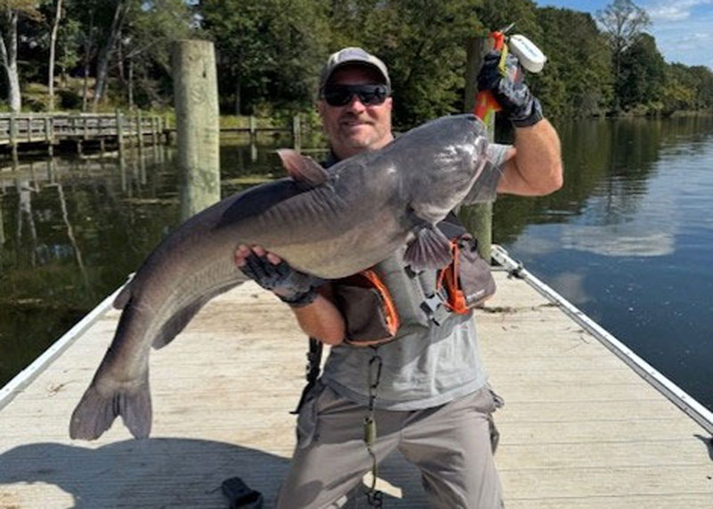
We receive plenty of reports of success from Mattawoman, which is a premier Potomac River creek for anglers to check out at all times of the year. In addition to the bass fishing—which can be good year-round—snakehead action can be very good here during the warmer months of the year. Moving into the fall and winter blue catfish, including some that are quite large, dominate the catch in Mattawoman. Fall, winter, and spring, crappie can be caught here. And in the early spring (March is best), Mattawoman sees an excellent yellow perch run followed by (in April) a run of hickory shad. Mattawoman is ranked eighth out of 137 watersheds in Maryland for species diversity, and it also offers excellent access for shoreline, kayak, and boat anglers. Smallwood State Park and Mattingly Park in Charles County offer ramps and shoreline fishing, plus fishing piers. There are also kayak rentals available (schedule ahead to ensure availability) at Mattingly via the Atlantic Kayak Company.
By Staff