It’s a curious thing that we might learn something about fishing structure from Edward Teach, dba Blackbeard the Pirate, or more precisely, from physical changes around his late ship, the Queen Anne’s Revenge. Found in 1996, the wreck is a national marine archeological and cultural treasure. Reports on exploration of this famous 1718 shipwreck off Beaufort Inlet in North Carolina explain how current interacts with objects on the bottom, causing scour, and how an object progressively settles in reaction to this scour.
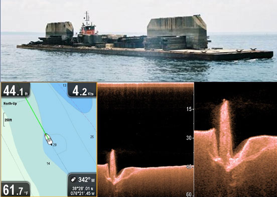
Some artificial reefs were inadvertently placed at locations prone to physical energy that produces heavy scouring. Take for example unanticipated deep scouring around and settling of concrete railroad bridge caps (Image 1) deployed in the Taylors Island Fish Haven during my time with the Maryland artificial reef program. They progressively settled into scour pits. The bridge caps could disappear into oblivion unless they reach bedrock before sinking entirely below the mudline.
Although scour hydrodynamics is a very technical topic, a basic awareness of flow interactions with objects is sufficient to aid in assessing scour patterns for fishing. Current flow above a threshold velocity that encounters an object deflects over and around the structure, causing turbulence. The constricted current stream increases in velocity, producing vortices along the front and sides and along the lee, and from there down current. Eddies touching the bottom then churn up sediment which is carried off in the current stream, leaving behind a scour pit.
Understanding Chesapeake Bay scour patterns also requires a basic working knowledge of water flow and circulation. There are, in effect, multiple Bays fed by tributaries which are distinctly different on each side of the estuary, and the way we fish them necessarily varies by the conditions we encounter. Half of the Bay’s water volume is freshwater fed by river systems. Most of the freshwater comes from watersheds at the north end and on the west side of the Bay. With one quarter of the Bay’s volume coming in from the Susquehanna River basin, almost another quarter coming in from the other westside rivers, and half its volume saltwater from the ocean, vastly varying circulation and salinity conditions exist across the estuary. Additionally, multiple old riverbeds and submerged landforms interact with water flow and tidal currents to further complicate circulation.
The direction of current flow is influenced by geography, riverbed and channel configurations, surface winds, water depth, and other factors. The Bay may be ebbing on one side and flooding on the other in some locations as the tidal cycle changes. Countercurrents with water near the surface moving in one direction and currents near the bottom moving in the opposite direction also occur. It’s also common for a tributary to still be flooding when the Bay at the tributary mouth has begun to ebb, and vice versa. Currents will also pile up on or be steered or split by formations that jut out into the current stream or down into the water column such as bridge piers, which obstruct the flow. Where turbulence, upwellings, and downward current vectors occur, baitfish are often disoriented, compressed into a smaller space, dispersed from a school, or delivered by the current conveyor belt to waiting predators.
It’s possible to scope prospective productivity in relation to current flows by studying scours. A feature in the middle of a scour indicates about equal exposure to ebb and flood currents in the Bay. Strong dominant currents produce a scour in the lee, that is, on the opposite side from which the current is coming. Thus, a deep scour on the up-Bay side of the feature means that the flood is dominant. If a scour is on the down-Bay side, then the ebb is dominant.
Many prominent scours are on the up-Bay side of features that are in, or in proximity to, deep water, or are on the eastern side of the Bay. Up-Bay scour in deep water is probably attributable to denser salt water in the salt wedge pushing up the Bay near the bottom on rising tides. Scours on the up-Bay sides of wrecks towards the eastern side suggest that floods tend to go up that side running counter to westside ebb flows during changes in the tidal cycle. Regardless, an up-Bay scour suggests a fishing feature with prime flood tide fishing activity, and a down-Bay scour suggests a feature best for fishing during the ebb.
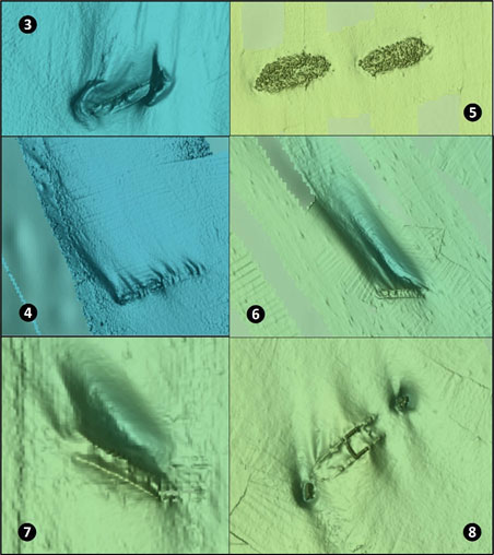
Site 4 on image 2 marks the broken remains of the submarine USS Dragonette, which was used as an explosives test site. The wreck is perpendicular to current flow and the scour is entirely on the up-Bay side. So, the dominant flow near the bottom is flood current. Site 5 marks two unidentified scows northeast of Point Lookout which are charted as an obstruction. Very slight depressions indicate that the wrecks aren’t much affected by current. However, they are covered and surrounded by huge riprap which was carried as cargo and are, in effect, artificial reefs, and fishing should be equally effective during either ebb or flood. Site 6 marks the wreck of a 59’ least-depth 195’ barge that sank in 1958. The wreckage is very low profile, rising less than a foot above soft sediment. However, there is a huge scour hole on the northwest side, so we know the dominant flow across this wreck is towards the northwest on flood tides.
Site 7 is the location of an unidentified 38’ least-depth wreck that rises 12’ from the bottom. It was discovered in 1949 just northwest of the northern end of the Rappahannock Shoal Channel when it was struck by a ship. The wreck is oriented northwest-southeast and angles across the dominant current, which we can see is the flood by virtue of a huge scour hole on the north side. Site 8 is the well-known “Texaco Wreck” southwest of Cape Charles City Harbor. The type, name, and when the vessel sank are unknown, but it was about 200’ long and rose about 15’ off the bottom when found. The broken off ends sit in scour holes where there is still substantial vertical relief. Configuration of the scours and sediment deposits show that this wreck lies across the current stream and receives strong currents during both flood and ebb.
A basic objective for light-tackle anglers is to determine where and when conditions are favorable for fishing. Although Bay fluid dynamics is an enormous and complex topic, the key point is to work to understand current interactions with each specific feature where you plan to fish, and under which current conditions a feature is most productive.
-By Wayne Young As well as being a regular contributor to FishTalk, Wayne Young is the author of multiple books detailing wrecks and fishing reefs in the Chesapeake Bay, Delaware Bay, and beyond. All are available at Amazon.com, and you can find his Facebook page at Chesapeake Bay Fishing Reefs.