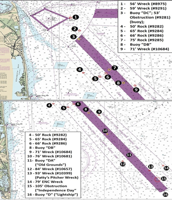
You might hear that fish like black sea bass and flounder are at the “DB” Buoy (commonly referred to as Buoy “B”) off Cape Henlopen. How often has that or a similar report been heard? It does seem that sportfish hang out in the vicinity of certain navigation buoys inside the Delaware-Cape Henlopen Traffic Separation Scheme (TSS). But, why are they there? Do fish like buoys? Nope — as it turns out, there’s a lot of productive structure within this TSS as shown by Chart 1.
This marine highway consists of a charted and buoyed marine pilot boarding area east of Cape Henlopen, a convergence zone charted as a precautionary area, the east-west Cape Henlopen-Five Fathom Bank TSS and northwest-southeast Delaware-Cape Henlopen TSS, and separation zones between the inbound and outbound traffic lanes. Ships, as a practical matter, can’t get out of your way because of traffic lane requirements and maneuvering characteristics, and those on the ship’s bridge may not be able to see you even though you can see the ship. Thus, it’s always incumbent on you to stay clear of commercial traffic when fishing.
So, why are fish found in the vicinity of buoys, particularly those marked on Chart 1? Think of these buoys merely as serving as convenient reference points.
Starting in the Precautionary Area, Site 1 is a 56-foot unidentified wreck at coordinates 38’46.402 x 74’58.675. A 1993 hydrographic survey found wooden and metal debris, a concrete block, and a chain. The wreckage was found again with side-scan sonar during a 2000 hydrographic survey. BAG imaging shows an anomaly in a scour with some small objects at the southwestern corner, as shown by the screenshot in the lower left corner of the Chart 2 enlargement. Whatever it is measures about 30 feet across using the BDV distance scale.
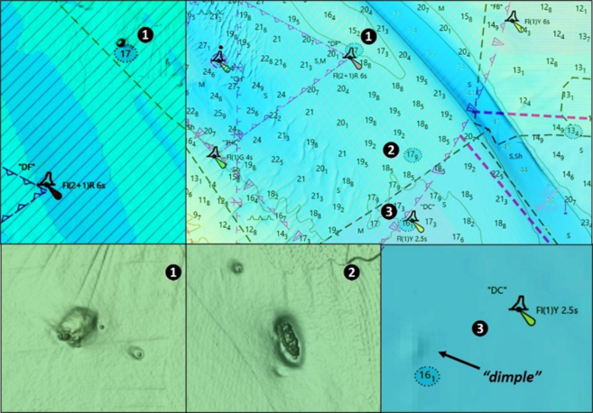
Site 2 is a 59-foot unidentified fishing vessel wreck in coordinate s 38'44.793 x 78'57.540. A BAG image is shown as the middle bottom insert on Chart 2. When discovered and investigated by divers during a 1993 hydrographic survey for the National Ocean Service, a single-screw metal wreck with evidence of fiberglass covering on the deck was found rising two to three yards off the bottom. Divers also found a fish net suspended by a buoy. The BAG image derived from a 2013 survey shows the vessel in a scour hole sitting upright. Vessel length is about 50 feet using the BDV distance scale.
At Site 3 there are two features. Buoy “DC” is on the centerline of the Separation Zone for the northern end of the TSS. Immediately west of the buoy is a 53-foot least depth obstruction that consists of a sunken buoy and a buoy anchor which is probably a concrete block. Found during the 1993 survey, it displays as a DEM image “dimple.” The buoy was most likely struck by a ship or tug and barge, cracked or holed, and then sank. Try working the edges which quickly fall off into the old riverbed.
Between Buoy “DC” and “DB,” there are four scattered rocks that were large enough for individual cataloging in AWOIS. They are marked as Sites 4, 5, 6, and 7 and are 50, 65, 66, and 75 feet deep, respectively. Site 4 is a large oblong rock sitting in a shallow scour at coordinates 38’39.501 x 74’57.072. The other three rocks are outside of BAG imaging. Charted positions are 38’39.018 x 74’55.040 x 38’39.446, 74’ x 54.247; and, 38’39.866 x 74’54.029, respectively. All four are at the same general latitude strung out from east to west suggesting possible outcroppings from an ancient ridgeline that intersected with the deep-water riverbed. The old river bed runs southeasterly down the inbound (east side) traffic lane and widens to over a mile towards the southern end.
About two nautical miles southeast at Site 8 is Buoy “DB.” Although the bathymetry is relatively smooth, the bottom slopes downward into the old river bed. North and south of Buoy “DB,” imaging reveals a narrow trough running southeast which is good flounder ground. At Site 9 east southeast of Buoy “DB” is an unidentified 71-foot wreck at coordinates 38’37.927 x 74’50.744. This wreck dates from 1971 and AWOIS records that it rises about five feet off the bottom. Think: sea bass.
Southeast of Buoy “DB” about 3.5 nautical miles at Site 10 lies a 76-foot-deep wooden wreck in the center of the separation zone. It was found during a hydrographic survey at 38'35.245 x 74'49.652. DEM imaging shows a “dimple” on the bottom. It’s worth a check for sea bass when in the area.
Southeast from the wreck 3.3 nautical miles brings us to Buoy “DA” (Site 11). The area around the buoy and to the north is the well-known “Old Grounds,” a highly productive area for flounder. The bottom is course and rocky, especially west and southwest of Buoy “DA.”
Southwest in the center of the outbound traffic lane at Site 12 is an 85-foot unidentified wreck at coordinates 38’31.444 x 74’47.468. The wreckage was detected by side-scan sonar during a 1999 survey. DEM imaging suggests rugged bottom, but there are no anomalies under the raster chart wreck symbol. If structure remains there, it’s low profile.
Southeast of “DA” along the eastern edge of the Separation Zone, look for what’s known as “Patty’s Pitcher Wreck” at Site 13 on Chart 3. This is a 93-foot-deep wooden wreck at coordinates 38’30.146 x 74’43.779. DEM imaging shows a prominent “dimple” under the raster chart wreck symbol. The wreckage is described by Divebuddy, a diver’s website as “... mainly a series of ribs with lots of nooks and crannies for bugs and fish to hide. The bow sports a large anchor and pony boiler out in the sand. The stern has a large rudder flat on the sand. Several gudgeons have been brought up in the last few years. She is thought by some to possibly be the Singleton Palmer, sister ship to the Elizabeth Palmer.”
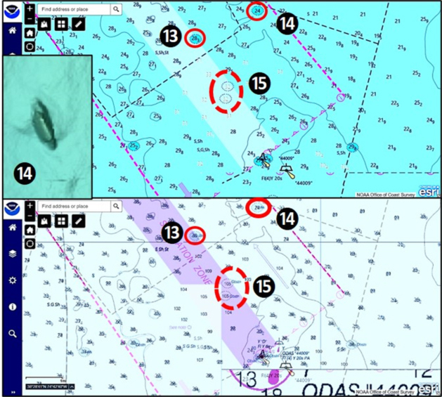
A short distance northeast in the inbound traffic lane at Site 14 is a 79-foot wreck, and just above the southern end of the TSS inside the eastern edge of the Separation Zone are 105-foot obstructions marked as Site 15. This is where lies an unidentified shipwreck known as the “Independence Day” wreck and also the “Bimbo Wreck.” BAG imaging shows a large object, but not with any detail. However, recent high-definition sonar scans by Ben Roberts, Eastern Search & Survey, reveal a low-profile distributed wreck that is about 240 feet long and 38 feet wide.
Back in 1921, the five-masted wooden schooner Singleton Palmer sank following a collision some 10 to 13 nautical miles from Fenwick Shoal Lightship. This wreck is a bit shorter than the Singleton Palmer, although it’s in proximity to where she went down. Located as it is in the bottom of the old riverbed, it’s a fish magnet especially for sea bass and tautog. Don’t pass this one by! And, don’t overlook the Eastern Search & Survey Google Map on the Internet and related posts on the ESS Facebook page. The map catalogs the sites investigated by ESS, including well over 100 sites in 2021, and has links to high-definition side-scan and multibeam sonar images, historical background, and in some cases, underwater pictures.
The southern end of the TSS is marked by Delaware Lighted Buoy “D,” formerly “DL”. This was the location of the Delaware Lightship, and the location is commonly referred to by that name. The bottom here is quite irregular, and is a flounder and sea bass hotspot. There’s a lot of bottom structure to prospect in the TSS. When fishing here, always be on lookout for shipping, keep a close eye on the weather and surface conditions, and wear a personal flotation device.
- By Wayne Young. As well as being a regular contributor to FishTalk, Wayne Young is the author of multiple books detailing wrecks and fishing reefs in the Chesapeake Bay, Delaware Bay, and beyond. All are available at Amazon.com, and you can find his Facebook page at Chesapeake Bay Fishing Reefs.
For more wrecks and fishing hotspots in this zone, also see:
Delaware Ocean Structure Part I: East of Indian River
Delaware Ocean Wrecks Part II: East of Fenwick Island
Sign up here to get the weekly FishTalk Chesapeake Bay and Mid-Atlantic fishing reports in your email inbox, every Friday by noon.