The Elk River, in the Way North fishing zone of the Chesapeake Bay, has lots of hotspots for anglers to enjoy some casting and catching. The National Ocean Service (NOS) has been conducting hydrographic surveys around Chesapeake Bay and its tributaries over the past several years to collect the data needed to update navigational charts. Bathymetric Attributed Grid (BAG) Color Shaded Relief imaging is produced from the acquired sonar data. One area that’s been surveyed recently is the lower Elk River, providing new insight into the fish-holding structure found there.
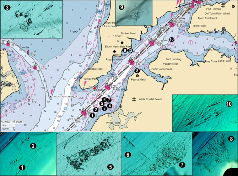
Scouting from south to north, look for depressions at Sites 1 and 2 on the shelf southeast of Buoy R 8 off Wroth Point. They appear dug out, perhaps for gravel or relic oyster shell but more likely the result of gouges created by barges which use the area as an anchorage. There’s a cluster of small gouges up to three feet deep at Site 3, coordinates 39°26.219 x 75°59.862. Site 4 marks a charted submerged jetty which was a wood bulkhead that rose about a foot above the surface at one time. They should hold fish but there may be broken pilings and boards below the surface, so be careful.
There appears to be a large area of uncharted objects at Site 5 distributed across the bottom in the charted pipeline area off White Crystal Beach across from Turkey Point (see bottom insert, Chart 1). Each object is actually a small hole up to three feet deep. The rectangular shape of the feature and the configuration and similarity of the holes makes them look like excavations, but barges use the area and these could be anchor gouges. Water depth is 12’ to 15’. Look for this area of very irregular bottom centered at about 39°26.381 x 75°59.567.
Immediately northeast at Site 6 is a pipeline which runs from the Eastern Shore side towards the northwest approximately in the middle of the charted pipeline area. This discharge line terminates with a trench pointing towards the ship channel. The outer half displays as a mound with a vertical rise of up to two feet. Towards its outer end, the pipe is exposed in several spots. It lies perpendicular to the current flow and thus is positioned to create turbulence. At Site 7 close to shore on the northeast side of the pipeline the bottom is very coarse. The bottom here looks as if it was scraped for undetermined material but again, it could have been caused by ground tackle.
Navigational charts for Arnold Point (Site 8), the northwest tip of Pearce Neck, don’t reveal that below the surface there is very rugged bottom with two prongs projecting out towards the ship channel. The lines shown on the Chart 1 insert are little ridges and are more or less across the current flow. The bottom configuration screams to be fished.
At Thackery Point is an area charted as “foul” (Site 9). This is another drowned point. The lines running out towards the east show as little ridges with vertical rise of about a foot down the slope across the current flow. Moving into the mouth of the Bohemia River, there’s a patch of about two dozen outcroppings (Site 10) at the head of the slough around coordinates 39°28.720 x 75°56.646. Vertical relief is one to two feet.
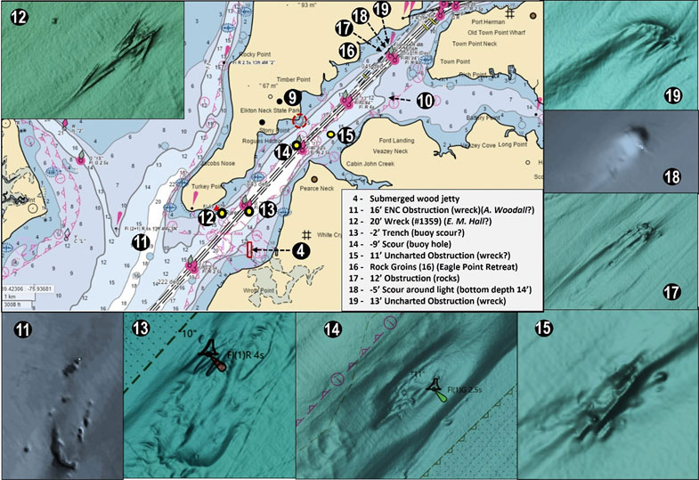
There’s a known but uncharted wreck (marked in general as Site 11) in the southern approach to the Elk River that may be the remains of the A. Woodall. If so, it was a wooden freight vessel that burned during a winter transit almost 100 years ago with the loss of the entire crew. This cargo vessel was a powered canal boat that ran from New York Harbor to the Chesapeake for ports of call. The low-profile wreckage matches a canal boat configuration (long and narrow). However, it’s frail in appearance and susceptible to damage from anchors. Coordinates aren’t disclosed because it’s considered a grave site and is susceptible to anchor damage. It’s included because it’s shown by the BAG data and to highlight the need to avoid damaging historic wrecks.
An uncharted obstruction at Site 12 may be the remains of E. M. Hall. According to the files, this was a cargo vessel which was lost in 1942 as the result of an unspecified marine casualty. Heavily processing the BAG data file suggests a broken-up wreck with the outline of a bow and several timbers at coordinates 39°26.730 x 75°59.833. There’s a wreck charted off to the northeast on the west side of the channel but BAG data doesn’t show one there, so it could be due to position error factors back.
Shadows at Sites 13 and 14 suggest wreck profiles when viewed in a two-dimensional display of BAG data. However, when viewed in 3D, Site 13 becomes two shallow trenches which are possibly gouges caused by displacement of the Buoy R 10 sinker. Because of the narrow trench profile, my guess is that the buoy was snagged by a tow and dragged off station. Site 14 becomes a scour around the sinker holding Buoy G 11. This hole goes down about nine feet below the shelf. As an old buoy tender sailor I’m not surprised that buoy sinkers are dragged and bounced around producing a scour, but I am surprised at the extent of some of the scour holes. Site 15 brings us to an uncharted obstruction sitting in a slight scour that rises up five feet from the surrounding bottom at coordinates 39° 28.122N, 75° 57.627W. It measures 60’ long and 12’ wide. This could be an outcropping, but the shape suggests a possible wreck. If the latter, the lack of distinct lines suggests a feature which is covered with sediment. It nevertheless stands out in otherwise flat surrounding bottom and thus provides reef habitat.
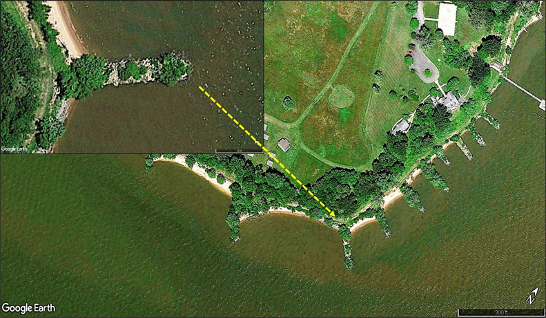
One of the more impressive Upper Bay structures is over on Elk Neck north of Timber Point at Site 16 (Image 1). It’s a series of 16 rock groins, some of which are huge, protecting the shoreline with the largest structures in front of the Eagle Point facility. Not far away to the northeast on the west side of Buoy G 15 there’s a pile of large rocks (Site 17). Northeast of the obstruction is a five-foot scour at Site 18 at coordinates 39°29.606 x 75°59.300, around the base of Elk River Channel North Range Front and Passing Light.
Site 19 could potentially be a small wreck by its profile, or an outcropping at coordinates 39°29.670 x 75°56.191. Dimensions are about 40’ by 15’. Although it only rises about three feet off the bottom, it’s a hard structure because a scour has developed on the down-current side.
When the striped bass season is open, these structures provide places to prospect. And when it isn’t, white perch and catfish swarm these waters. However, remember that the features and shipping channel are in close proximity. Large ships such as car carriers use this route, so pay attention to their movements, stay clear, and watch out for bow and stern wakes.
-By Wayne Young, the author of “Bridges Under Troubled Waters: Upper Chesapeake and Tidal Potomac Fishing Reefs,” “Chesapeake Bay Fishing Reefs, Voyage of Discovery,” “Phantoms of the Lower Bay,” and “Hook, Line, and Slinker,” and more. All are available at Amazon.com.