Those who fish the Virginia side of the lower Potomac River know the edge off the lower north coast of Smith Point well. Ebb currents distribute bait along this edge. In the fall, waiting schools of stripers chow down on schools of bunker carried along by the current. When the fishing is tougher and the fish are in close to shore, there are a good dozen spots to check out between Great Point and Smith Point.
Northwest of Great Point about 600 yards at site 1 on chart 1 are three uncharted elongated mounds. A private buoy marked 1A is at the southeast end of a mound which is about 200 yards long and 25 yards wide. The other two are to the northeast and are longer. All three stand out in Digital Elevation Models (DEM) Color Shaded Relief using the Bathymetric Data Viewer.
Southeast of Great Point is Cod Creek. At the upriver entrance there is a longshore, intertidal rock breakwater (site 2). A tombolo connects the center section to the shoreline. The southeastern third of the breakwater where the shoreline turns to the south juts out and is always submerged. Southeastern end coordinates are 37'58.831 x 76'26.321. There is scattered rock immediately southwest of the southeastern end. There is also some scattered rock in front of the rock armor on the shoreline to the south. Prospect the entire breakwater with special attention paid to the southeastern end.
The downriver entrance to Cod Creek starting at the northwest point of Bay Quarter Neck is armored with modern rock shoreline protection structures. A number of short jetties jut out from the toe of the armor. Several old submerged breakwaters (site 3), each about 75 feet in length, are parallel to the shoreline southeast of the point. Further southeast where the shoreline makes a quick turn to the south before turning back to the southeast at a long sandy beach, there is a curved underwater shadow. This possibly could be an old, failed, dispersed shoreline protection structure. The center point of the shadow is 37'58.222 x 76'25.245. There is no confirming information, however, the signature suggests an anomaly rather than merely vegetation on the bottom.
Pressley Creek is a large sheltered tidal pond. Its entrance is narrow and unprotected by jetties. The long inlet channel leading to the pond behind the shoreline is extensively shoaled. On the south side of the inlet, there is a series of four segmented breakwaters along the shoreline (site 4). The easternmost two breakwaters, which form a mini-harbor for a dock, jut out far enough to interact with currents and may be worth a cast or two. Immediately to the south across the end of the Presley Creek pond, there’s a substantial rock-protected dike. Just to the south are three short rock breakwaters in a semicircle extending about 50 feet off the shoreline.
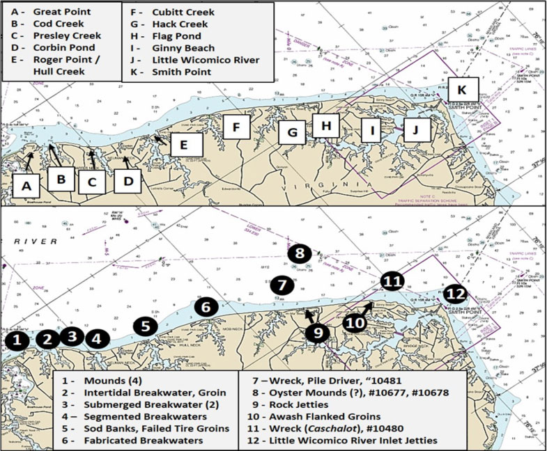
Southeast of Pressley Creek at the westside of the entrance to Hull Creek (site 5), the shoreline has suffered greatly from erosion. Immediately evident from a 2015 satellite image on Google Earth is sand on top of vegetated low bank shoreline. This means that sand was scoured from in front of the low bank shoreline and transported by storm surges during overwash onto the bank. The sod edge was thereby exposed, making it the shoreline. In this case, there are three ragged sod points that jut out towards the river. For light tackle fishing, this is one of the shoreline conditions to look for. But, it also spells bad news for the shoreline…
By 2021, the eastern half of the wide sandy beach that ran west to the mainland had been displaced about 500 feet to the southwest on top of islets behind the former shoreline. Substantially more of the middle and eastern little points scoured free of sand and submerged. Multiple satellite images show the eastern portion of the low bank that was north of the lodge completely submerged. Hull Creek surely has more surprises waiting for us in the future!
The open water area in the creek entrance provides another example of where shoreline protection structures made from tires failed miserably. Looking at the chart today, Hull Creek has a wide-open mouth that provides access to three arms. Remnants of multiple shore stabilization and protection structures are in the middle of the entrance about where they’re shown on Chart 2. Zooming in on satellite images shows these objects are tires and are now uncharted obstructions to navigation, and also demonstrates the value of satellite images for scouting fishing structure. There appears to be a stake marking the eastern end of the easternmost string of tires. Why are tires at this location? An 1868 Coast Survey nautical chart included as the bottom left insert on Chart 2 provides the answer. The creek was protected by a narrow low bank shoreline. The barrier bank appears to have initially breached on the east side of Hull Creek whereupon the low bank became a barrier peninsula. Its eastern end was named Rogers Point, presumably after Rogers Creek which is the easternmost of the three creek arms. A breach on the east side would have been the shortest discharge point for coastal flooding of the creeks by storm surges. So, an eastside breach isn’t surprising. Parties unknown attempted to save the barrier peninsula by installing tire groins, which failed to stabilize the shoreline, and Rogers Point progressively eroded westward and is now submerged, the shoal water in the opening.
Hull Creek entrance on the east side is also strewn with failed tire groins that fan out around the point and extend out about 50 yards from what is now a rock-armored shoreline. There is also a submerged breakwater parallel to the shoreline immediately east of the point. It’s located between two wooden bulkheads and consists of five black rectangular objects that by appearance could be bound and weighted tire units. There are at least six more tire groin remnants towards the southeast interspersed between wooden jetties. The tire remnants are included here more for safety awareness than as fishing destinations. Better spots to check are the submerged banks on the west side of the entrance, which may attract striped bass and speckled trout.
About 2800 yards further down the shoreline from Hull Creek is the Cubitt Creek outlet where there’s another pocket beach. It is about 400 yards wide and runs across the northwest corner of Lowes Pond. Considering what transpired at Hull Creek, finding shoreline change at this pocket beach wasn’t surprising, albeit on a much smaller scale. The northwest corner of the pond is formed by a short, thin strip of land. About 200 feet out from the beach are three segmented breakwaters at site 6, each a potential casting destination. The western and middle breakwater consist of a single row of hexagon-shaped cofferdams. There are two rectangular boxes on the river side of the western structure. The eastern breakwater is formed by a single row of five hexagon-shaped cofferdams and 10 rectangular open boxes. The boxes are partially filled with material. These breakwaters all appear to be made with poured concrete boxes. Although they help break up wave energy, they weren’t sufficient to preclude storm waves and surges from scouring and narrowing this little protective strip. Sand was scoured and carried over the top into Lowes Pond and on top of adjacent low bank land, which occurred after satellite images were taken in 2015. The corner of the pond is at risk of breaching. When it does, the pond will become fully tidal, if it hasn’t already happened by the time you read this.
About 800 yards off the north end of Hack Creek inlet which satellite images show clogged by ebb and floodtide shoals, look for a 13-foot-deep wreck. This is AWOIS Number 10481, a pile driver (site 7), at coordinates 37’56.328 x 76’18.478. No other description is in the file. About 3400 yards northeast of the inlet are two obstructions (site 8), AWOIS File Number 10677 (coordinates 37'56.847 x 76'17.216 and Number 10678 (coordinates 37'56.625 x 76'17.812. They are charted as 26-foot and 25-foot least depth obstructions respectively, and both were thought by the surveyors to be oyster mounds.
Site 9 at the southern end of Val-Mar Beach is the location of two rock groins on either side of Flag Pond Inlet, and site 10 marks multiple rock structures charted as ruins at a short dogleg in the shoreline at Ophelia. On the western end of the dogleg, rock armor on the shoreline juts southeast into the water where the outer end submerges. Five submerged rock groins jut out towards the river along the northeastern side of the feature. There is a large rockpile immediately to the southeast, and 100 yards southeast of the first rockpile is another about 125 feet off the shoreline.
About 500 yards offshore at site 11 is the charted wreck of Caschalot, AWOIS File Number 10480, at coordinates 37'54.914 x 76'15.579. This vessel went hard aground in 1937 and broke up, leaving only the motor at the wreck site. Site 12 brings us to Smith Point itself and its two long rock jetties. The ebb current rips around the end of the jetties, and there is a strong discharge from the Little Wicomico River. The outer end of the inlet gets very nasty when strong winds, large waves, and strong currents interact. Foraging striper schoolies are sometimes inside the inlet, but fishing in there can be difficult due to physical conditions and boat traffic.
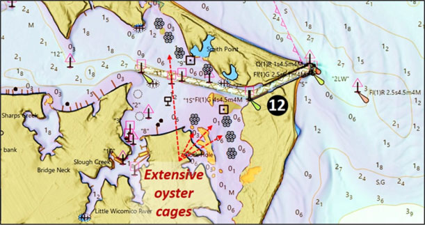
Rock Hole, the arm that extends due south from the southwest end of the inlet, is very shallow and full of oyster cages – making it great kayak fishing water. The cages extend up alongside Bamboo Island. There are also extensive oyster cages that extend out from the shoreline on the north side of the channel north of Bamboo Island northwest up into the first cove.
With so much structure and so many hotspots close together in a relatively small area, this section of Smith Point belongs on every Potomac River angler’s radar. Pay it a visit and see what bites.
- By Wayne Young, the author of “Bridges Under Troubled Waters: Upper Chesapeake and Tidal Potomac Fishing Reefs,” “Chesapeake Bay Fishing Reefs, Voyage of Discovery,” “Phantoms of the Lower Bay,” and “Hook, Line, and Slinker.” All are available at Amazon.com, and you can find his Facebook page at Chesapeake Bay Fishing Reefs.
Sign up here to get the weekly FishTalk Chesapeake Bay and Mid-Atlantic fishing reports in your email inbox, every Friday by noon.