When thinking about the Chesapeake and its tributaries as fishing destinations, striped bass fishing first flashes across our internal scroll. But that’s only part of the Chesapeake region’s fishing story. Much of the Upper Bay and middle to upper portions of the Bay tributaries are more or less freshwater fisheries. So, those of us who fish in their freshwater reaches think about bass and crappie in addition to rockfish and bluefish. One of the better bass fishing tributaries around is the James River’s Powell Creek. The creek is accessible by powerboat from the James River and is a great kayak and canoe fishing destination as well.
A hundred years ago, Powell Creek had several wood landings where products were loaded and shipped on small commercial vessels. Back then, the creek had depths to as much as 18’. When heading up Powell Creek, much of the left ascending side of the creek is part of the James River National Wildlife Refuge (NWR), owned and operated by the U.S. Fish and Wildlife Service. Two miles up the creek, the NWR has a recreational landing where kayaks can be launched.
The Virginia Department of Wildlife Resources (DWR) reports that Powell Creek is one of the best bass fishing bodies of water in the tidal James River system, but without elaborating why. The answer is high quality aquatic habitat, plus structure. The vegetated shoreline has trees along the water’s edge with deadfall, extensive fringe marshes, and numerous small feeder creeks. At high tide the water is in the tree line. And there’s artificial structure which adds to the creek’s fishery habitat. Duck blind and duck blind ruins provide shade and cover, plus there are barge wreck clusters.
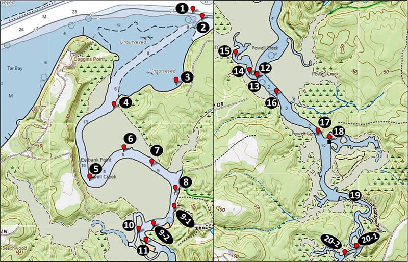
Site 1 marks the James River entrance to Powell Creek. A small obstruction is on the east side of the entrance at Site 2. This unidentified feature is about 20’ long and 15’ wide with a vertical rise of about three feet. The entrance opens to a small cove on the southeast side. There’s a duck blind adjacent to the shoreline deep in the cove at Site 3. Just after the creek narrows inside the entrance, there’s a duck blind ruin at Site 4 in an eastside feeder creek outlet.
Scoured trenches and holes are deep in the bends; check each at low water, as this is often where fish retreat. About 800 yards upstream from Site 3 is a sharp bend around Eelbank Point marked as Site 5. Site 6 marks another scoured trench deep in the bend. Site 7 marks a duck blind, and another scour is at Site 8.
Back in the day obsolete vessels were abandoned on flats, in played out sand and gravel pits, and up inside creeks. In this regard Powells Creek doesn’t disappoint. There are three clusters of wrecks up the creek. The shoreline in the next bend starting at Site 9-1 and ending at Site 9-2 is lined with wrecks which by appearance were barges (Image 1). The wrecks are all highly deteriorated, broken up, and consist of frames and timbers. Some have trees growing out of them. Several are canal boat style, measuring 200’ long and 20’ wide.
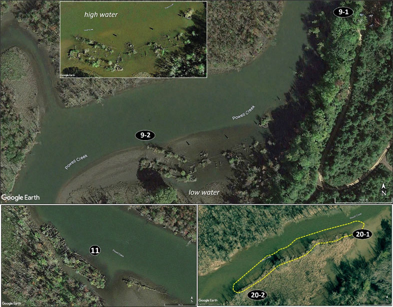
Northwest across Powell Creek is the outlet of a small creek loop. Directly west of the wrecks at Site 10 is a breach in the loop neck with a duck blind in the opening deep in another sharp bend. There’s a scoured trench in front of the breach for the fish to retreat to at low water. Immediately up-creek from the bend is another cluster of wrecks at Site 11. There are three wrecks here, two of which have a lot of timbers (Image 1, bottom left insert). The wreck on the down-creek end sticks out and has a little water at low tide. Site 12 marks the outlet of a small feeder creek. There’s a duck blind along the shoreline at Site 13. Inside the creek, look for a row of pilings at Site 14. There’s an opening where the creek channel passes through and leads to a wooden boardwalk on pilings at Site 15, which obstructs further access. The pilings look inviting at high tide but fall bare except for the shallow creek channel at low water.
Heading up the creek there are a few charted obstructions along the western side. There’s an obstruction at Site 16 which is a possible duck blind ruin. Site 17 marks a duck blind in the center of the creek. At the outlet of a feeder creek there’s a duck blind ruin at Site 18. It barely uncovers at very low water. When the water is up there’s a lot of marsh edge to cast to, and at very high levels the edge of the tree lines, but don’t get caught in here on a falling tide.
There’s a lot of marsh edge which doesn’t fall bare at low tide from Site 18 up-creek to Site 19, the NWR landing and kayak launch. The creek narrows beyond the landing. Further upstream just before the creek narrows even further, there are obstructions along 150 yards of the southeastern shoreline starting at Site 20-1 and ending at Site 20-2 (Image 1, bottom right insert). By appearance they’re vessel remnants and appear like long longitudinal frames or timbers which are at the mudline and barely uncover at very low water.
Caution: With the presence of duck blinds, fishers must make themselves aware of duck hunting season. During the season stay as far as possible from blinds which appear to have ducks around them, as there’s a good chance the blind is occupied and those are decoys you’re looking at.
As well as being a regular contributor to FishTalk, Wayne Young is the author of multiple books detailing wrecks and fishing reefs in the Chesapeake Bay, Delaware Bay, and beyond. All are available at Amazon.com, and you can find his Facebook page at “Chesapeake Bay Fishing Reefs.”