Fish relate to structure, hence the traditional use of artificial structures to create Chesapeake Bay fishing reefs and aggregate fish. Build it, and they will come — if physical, environmental, and biological conditions are suitable. Establishing artificial reefs is also a way to restore marine habitat. Smart reef design can concurrently provide marine habitat for predators and prey, increase an area’s biological carrying capacity, support building fishery stocks, and provide sportfishing opportunities. Virginia Marine Resources Commission (VMRC) artificial reefs display all four traits, and one also directly supports a specific marine species. Although most VMRC artificial reefs were established using saltwater license fee funds in order to support sportfishing, replenishing non-gamefish fish stocks was also a fundamental objective. And, the Virginia approach informed reef development for Maryland's Bay fishing reefs during my service as reef manager.
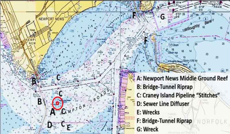
Newport News Middle Ground Reef, location A, is a great example of how to use an artificial reef to replenish a non-gamefish marine species as a primary objective. Located at the mouth of the James River in the middle of Tidewater, it was established as both a brood hard clam sanctuary and fishing reef. Piggybacking these two purposes enabled moving this reef from concept to field application.
This urban reef is a powerhouse, and extensive marine habitat is laid out across most of the site. The fish haven also is surrounded by other artificial structures, wrecks, and natural features in a harbor that provides some protection for small boats. Upstream in the James River, there is another bridge and tributaries including the tidal Nansemond River. The combination makes this entire area a fishing hotspot.
Site selection for the Middle Ground reef was guided by a hydrodynamic modeling study of hard clam larvae dispersion performed by the Virginia Institute of Marine Science (VIMS). The commercial hard clam industry and other interested parties were consulted to obtain advice and cooperative engagement. This led to acceptance of the Middle Ground as a permanent “set-aside” brood clam sanctuary. Combining the set-aside with a State-sponsored fishing reef made great sense, since Virginia law prohibits commercial harvests within the State's artificial reef sites. Although artificial reef status doesn’t prevent poaching, such designation and the presence of reef structures with large mass and high vertical relief are strong deterrents to illicit harvesting. The Middle Ground area is also a natural sportfishing hotspot for many species including striped bass, croaker, and even black drum. Reef structures and the Lower Bay location also make the site suitable for black seabass and tautog.
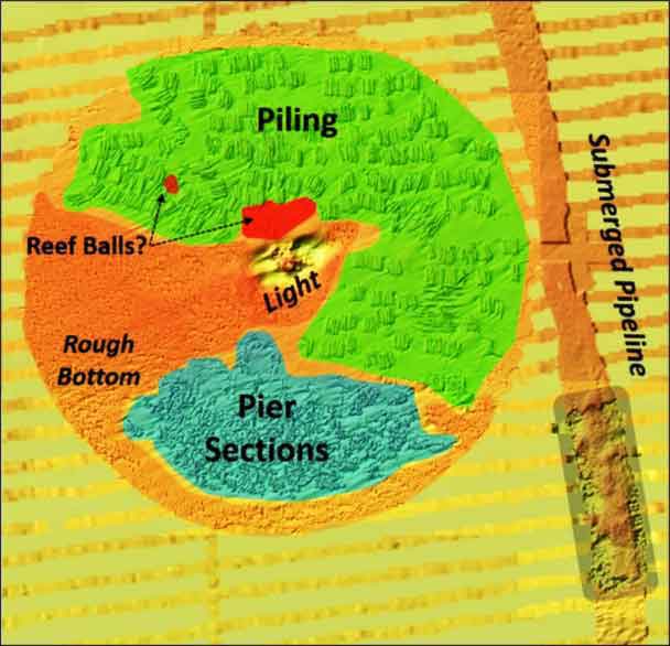
There’s no need to worry about a reef buoy being carrying away from here, as Newport News Middle Ground Light sits right in the middle of the donut-shaped reef site. The fish haven covers a circular area between 200 and 1000 feet around the lighthouse. This beacon is the oldest caisson “sparkplug” shaped lighthouse in Virginia. Painted red, it can’t be missed. With biofouled iron plates forming the caisson and rugged bottom around the base, it’s a fishing reef in its own right. Today the lighthouse is privately owned, having been declared excess property and sold to the highest bidder. However, the Coast Guard holds an easement and right of access for the navigation light at the top. The owners made a substantial investment in refurbishing the structure, which had fallen into disrepair after the light was automated. The caisson is surrounded by a deep hole scoured by the currents which sweep around the base. The caisson exterior and a steep vertical drop-off offer casting and jigging opportunities.
The fish haven, in effect, forms a raised underwater plateau around the scoured donut hole. There’s 10 feet or so of vertical relief. Least minimum depths in the northern half of the site coincide with the largest material of opportunity; reefs consisting of piling. Many clusters of piling in groups form a “patch” reef layout. There are also some small round objects around the northern edge of the donut hole along the southern edge of the piling clusters. A number of reef balls were also placed in the site. Review of side-scan sonar images from the National Oceanic and Atmospheric Administration (NOAA) Bathymetric Data Viewer (BDV) suggests that these objects could be the reef balls.
Reefs in the southeast quadrant and lower half of the southwest quadrant consist of pier sections laid closely together and spread tightly across the bottom in a “smear” reef form. Although artificial structure is not readily apparent in the upper and western portion of the southwest quadrant, this wedge-shaped area is swept by strong currents, and the bottom presents a very coarse appearance in side-scan sonar images. After checking with the VMRC staff, although not specifically stated in the files, this area was probably left undeveloped to serve as the deployment location for seed clam.
With all the structure that is available in the fish haven, there may be multiple sweet spots on any given day. Reef materials are very rugged in character, though. Losing tackle to snags is common, so some fishermen will avoid the reef site to cut their losses. If that’s you, read on. There’s plenty of other structure to check out!
The reef is sandwiched between the southern Monitor-Merrimac Bridge-Tunnel (MMBT) Island and the submerged Craney Island pipeline on the east side. The bridge-tunnel northern shoreline terminus and island (location B) are heavily riprapped. The tunnel is buried well below the mudline except where it rises into these filled areas. There it is covered with riprap to protect against vessel strikes. Along the Newport News shoreline in the general vicinity of the northern terminus are hulk outlines of old derelicts. The bridge spans are supported by numerous concrete piles, any of which could hold fish as fishing conditions change during tidal cycles.
The pipeline to the east (location C) is buried. However, there are five locations which have disturbed bottom. These are “stitch” points, essentially filled in excavated ditches, where pipeline sections are joined. There’s no physical protection over the pipeline, but the bottom is irregular. It runs from Newport News to Craney Island, the U.S. Army Corps of Engineers containment facility for dredged material.
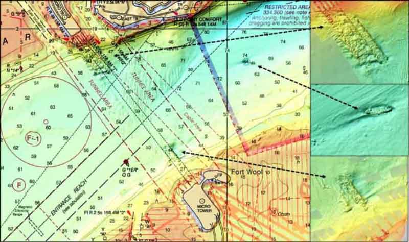
Southwest of the fish haven, there is a sewer pipe (location D) that runs northeasterly from the shoreline. At the discharge end of the pipe, there is a long diffuser. Nearby to the east of the diffuser are several obstructions and wrecks (location E), although the objects shown as obstructions could be vessel wreckage from their appearance. Five miles northeast of the fish haven, there are the Hampton Roads Bridge-Tunnel (HRBT) Islands (location F). As with the MMBT tubes, the tunnels are buried well below the mudline except where they rise into the islands and are covered with riprap. The bridge span portion of the complex also has many trestles supported by concrete piles. Just to the east of the channel opening between the islands lies a well-defined shipwreck (location G). The wreck is in about 60 feet of water.
Major construction is forthcoming at the HRBT. Two new tubes will be constructed on the west side of the existing structure. All of the trestles on the Norfolk side of the complex are also planned for replacement, and there are future plans to widen the channel on either side of the islands. If all the artificial structure including wrecks and obstructions weren’t enough to make Hampton Roads harbor a hotspot, there are plenty of channels edges and shoals.
The harbor is a wide body of water. Yet, it provides some shelter on days when conditions are not suitable for operating small boats out on the Bay. Although the fish haven is outside of the channel, Hampton Roads is a busy harbor with a combination of commercial fishing, ocean shipping, assist tug, tug and barge, and naval vessel operations. Always be watchful for larger vessels which are constrained in their ability to maneuver in harbor channels. Remember, small boats disappear from sight under the bow of large ships and when obscured by cranes and cargo. Enjoy fishing the area, but give the big guys plenty of room.
See our Chesapeake Bay Fishing Reefs Guide to get the lowdown on other mad-made wreck and reef hotspots in the Bay, plus a few in the ocean off the DelMarVa coast.
-By Wayne Young, a former manager of the Maryland artificial reef program for Bay waters and the author of “Bridges Under Troubled Waters: Upper Chesapeake and Tidal Potomac Fishing Reefs." You can also visit his Facebook page, Chesapeake Bay Fishing Reefs.
Sign up here to get the weekly FishTalk Chesapeake Bay and Mid-Atlantic fishing reports in your email inbox, every Friday by noon.