The Severn River offers sheltered waters with extensive structure and lots of fishing opportunity for days when going out to open Bay hotspots like the Bay Bridge or Thomas Point is a no-go. Much of this structure consists of oyster reef restoration projects that were constructed over the past decade. This structure is in addition to road and railroad bridge foundation ruins, an artificial reef, bridge piers, and a reef ball water quality field test and fishing reef.
Working from Annapolis upriver, there are two deepwater anchorages (Site 1), one at the mouth of Back Creek and Annapolis Harbor South Anchorage Area at the entrance to Spa Creek. The latter has four large rectangular excavations with drop-offs from about five to nine feet around their perimeters. When the area isn’t heavily populated by sailboats, note that the outer edges of the dredged anchorages have drop-offs of between about 10’ up to about 40’ along the perimeters. In particular, the southeast side of the submerged end of the Horn Point shelf has about a 10’ drop-off that’s worth a look on an ebb tide.
Site 2 marks a submerged point at the entrance to a small boat basin on the north side of the river across from Spa Creek. It juts out sharply into the ebb current flow and has about a 10’ drop-off. A small hump on a shelf just upriver at Site 3 is more substantial than charted. It’s about 60 yards long with a five foot drop-off on the northeast side and a 10’ drop-off on the southwest side.
Turning the corner and heading upriver from Spa Creek, the river bottom quickly gets very interesting. Between the Route 50 and Route 450 Bridges (Chart 2) features a state reef, the foundation ruins of the first Route 450 Bridge, a public fishing pier, ruins of an old railroad bridge, and constructed oyster reefs supporting ongoing oyster restoration initiatives. These various bottom features also provide lots of recreational fishing opportunity.
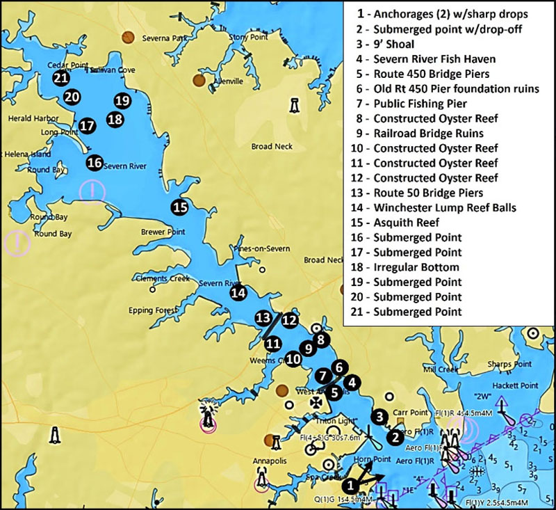
Oyster restoration was one of the early objectives for Maryland’s artificial reef program. Perhaps this explains why the Severn River State Reef was shown on nautical charts (Site 4) as an oyster reef (sometimes oyster bed) rather than as a fish haven. It was permitted in 1994 to receive rubble from demolition of the old Route 450 Bridge (Site 5). Tucked alongside the Route 450 Bridge, the reef site has little room for maneuvering. Access from the upriver side of the bridge is constrained by bridge piers and a restricted area that is closed to boats. Boats are required to stay out of the area marked by white and orange buoys in front of the northeast end of the old 450 bridge, which is now a recreational fishing pier (Site 6). However, foundation ruins of the old bridge extend all the way across the river (Site 7). This is a sheltered area when northeasterly winds are blowing, but fishing here can be tough due to snags, and drift fishing is nearly impossible.
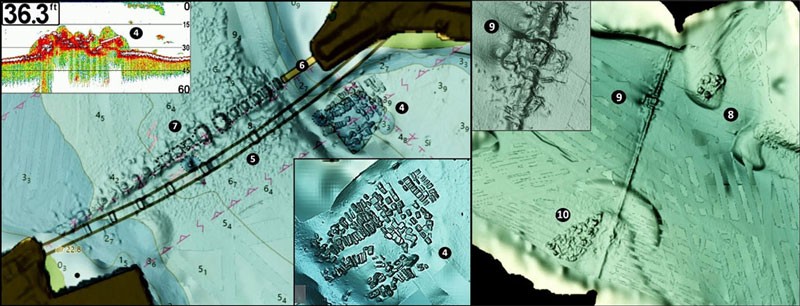
Site 8 on the northeast side of the river just below the railroad bridge ruins (Site 9) is a constructed oyster reef. The substrate for the reef was placed on top of a submerged point. Just to the southeast is another submerged point. Between them is a trench. Try working across the entire site.
Before the extensive highway system folks coming down to Annapolis from Baltimore and surrounding areas often came by train, over the old Baltimore and Annapolis Railroad Bridge. Its foundation ruins are located about halfway between the Route 450 and Route 50 bridges. The charted ruins extend across the river. This is a fishing hotspot generally, and the former swing span turntable in particular. Try here for striped bass. Site 10 on the upriver side of the ruins along the southwestern shoreline is another constructed oyster reef that’s a good possibility for white perch.
There are five constructed oyster reefs charted downriver from the Route 50 Bridge. Site 11 on the southwest side parallels the shoreline for about 125 yards along the northeast edge of a shelf. A smaller semi-circular constructed reef juts from its northwest end. This reef’s position and shape should disrupt current flow and create turbulence. Site 12 marks three constructed oyster reefs on the northeastern side of the river. The southernmost reef on the western edge of a shelf that angles out into the river puts this reef in position to receive ebb current flow. Site 13 is the Route 50 Bridge. Try a test jig or two at the bridge piers for stripers.
Site 14 on Winchester Lump, although another constructed reef, is substantially different from the aforementioned reefs consisting of substrates placed as a bed for seeding with oyster spat on shell. Located just below the south-side entrance to Chase Creek, it consists of 240 reef balls with hatchery-set oyster spat. They’re distributed across the site in small clusters (Chart 4). The reef is a field experiment to test whether such reefs can break up dead zones of low oxygen. The reef balls were deployed by the Chesapeake Bay Foundation (CBF) during 2018 in partnership with the University of Maryland Center for Environmental Science (UMCES), and the Naval Academy monitoring performance. Check here for perch and stripers.
Site 15 marks Asquith Reef located off the mouth of Asquith Creek, on the northeastern side of the river. The project was a partnership effort with CBF, Maryland Artificial Reef Initiative (MARI), and Maryland Department of Natural Resources (MDNR). The base material is composed of 5063 tons of recycled and crushed concrete rubble from bridge decking. This substrate was overseeded with oyster shell and oyster spat on shell.
Structure further up the river consists of natural formations, primarily submerged extensions of points. However, there is a wide area of holes and narrow trenches marked in general as Site 18 east southeast of Kyle Point and from there upriver about 3,000 yards. The trenches and holes are widely distributed and as much as 10’ deeper than the surrounding bottom. My impression from various sonar data displays is that they’re excavations, possibly from relic oyster shell mining. Regardless of how they got there, these are features to prospect. The larger of the features are between Kyle Point and Round Bay. Try the 34’ least depth deep trench at coordinates 39°03.116 x 76°33.074. And don’t forget to check the point and the sharp edge on the west side of Round Bay at Site 19. The upper Severn River and its feeder creeks are winter pickerel fishing destinations.
Bay tributaries are akin to large tidal lakes which often offer sheltered waters when the main stem is too rough to fish. The Severn River is one of the more diverse in terms of the structure available for prospecting. There’s also a public boat ramp up Spa Creek at Truxton Park in Annapolis, which provides a well-protected launching area with modest parking for vehicles with boat trailers
-By Wayne Young
As well as being a regular contributor to FishTalk, Wayne Young is the author of multiple books detailing wrecks and fishing reefs in the Chesapeake Bay, Delaware Bay, and beyond. All are available at Amazon.com, and you can find his Facebook page at “Chesapeake Bay Fishing Reefs.”