When we presented The Cell in the March 2020 issue of FishTalk, the Bathymetric Attributed Grid (BAG) Color Shaded Relief data layer, essentially side-scan sonar-like imaging, wasn’t available for this site from the Bathymetric Data Viewer. Then in the December 2021 issue, we reported a change in the BDV basemap from raster to Electronic Navigation Chart (ENC) format. We also noted that NOAA had uploaded additional BAG imagery for select locations. The Cell was not only one of the beneficiaries, but also the data was developed from a recent 2020 hydrographic survey, so there’s new insight into this fishing hotspot. Taking advantage of the new BAG imagery, we took a fresh look at this artificial reef to see what revelations might be forthcoming about the substantial artificial material reefs shown in Virginia Marine Resources Commission (VMRC) layout graphics, in addition to the pre-existing degaussing station ruins.
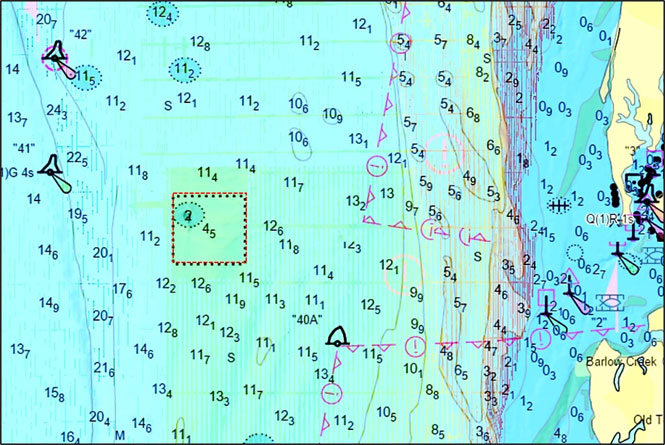
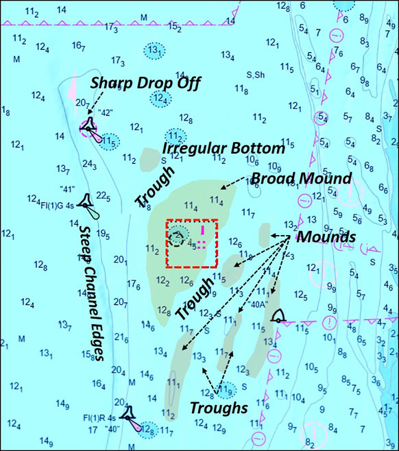
The Cell is three miles west northwest of Mattawoman Creek Light number one off the mouth of Hungars Creek, and about six miles southwest of the mouth of Nassawadox Creek (as seen on Chart 1). The fish haven location was well chosen. Natural features and artificial structures provide diverse marine habitat, making the area attractive to sportfish, and this spot is known as a top producer for this area of the Bay. Color shaded relief derived from sounding data show a deepwater channel nearby to the west, and suggests variable bathymetry north and south. Electronic sonar charts from various other sources show mounds and troughs to the south, and irregular bottom to the north. Our interpretation of this data is shown by Chart 2.
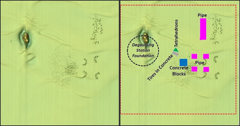
Previously, structure coordinates could be extracted from grid layouts available on artificial reef webpages maintained for the Virginia program by the VMRC. Position error was possible inasmuch as early reef deposits were originally positioned using Loran C, and not all were verified using GPS. When the VMRC data are overlaid on the BAG image and aligned with the ENC charted reef boundary, the icons are offset from actual positions by about 100 yards, which is consistent with the Loran C positioning error factor. Graphic layouts included on the VMRC reef map webpage were nevertheless essential in orienting to the displayed reef deposits.
Geometric icons also only depict the approximate perimeters of areas where placements were made, but not the actual configuration of the materials. What we found when realigning the icons to the reefs to BAG imagery was that placements of pipe and block correspond well to the icons whereas the earlier deposits of tetrahedrons and tires in concrete are more widely dispersed (Image 1). These latter reef deposits are heavily sedimented. Consequently, they are indistinguishable by type.
Irregular patterns, patch reefs, smear reefs, and half-circle forms typical of many other VMRC reefs are encountered here as well, providing a variety of fishing conditions. A patch reef layout, typical for many VMRC fish havens, results in many individual structures in proximity to each other. Fish may relate to a specific structure on any given day, or may move around between structures. Finding the sweet spot or spots within any fish haven requires patience. But at VMRC fish havens, some structures are close together. By positioning among them, lures and jigs can be cast to multiple reefs from a single position. Or, a boat can anchor up-current and float a live-lined spot or cut bait in a chum line back to a reef.
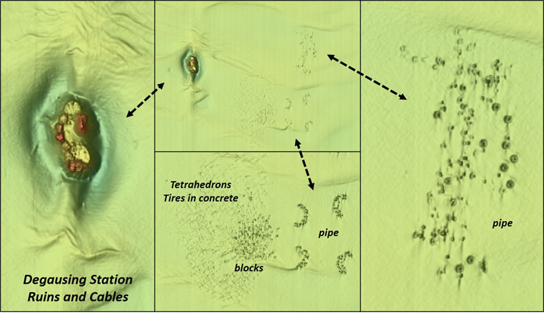
Zoomed in screenshots of fish haven features and the degaussing station ruins are shown by Image 2. The concrete pipes were donated by Hanson Pipe Company in 2001. Nested pipes donated by Hanson were placed at some of the other VMRC reefs, and possibly this approach may have been used here as well, although the modest definition of the BAG imagery isn’t sufficient to make an assessment. Regardless, the pipe and block reefs are prominent and worth checking out.
The northwestern quadrant of the fish haven was the site of Wolf Trap Degaussing Station, one of several in the Bay. These facilities were used during and after World War Two for demagnetizing ships as a defense against magnetic mines. Today, the Wolf Trap station’s foundation remains on the bottom along with cables. The position of this artificial structure is offset just to the north of where they are depicted in the VMRC icon layout. Various fishing reports say to work the foundation around the edges — if you try to drift through, be prepared to say goodbye to a lot of tackle. With the updated BAG relief data, we can see the wisdom of this advice! Nevertheless, it is the dominant feature within the fish haven and well-suited to tautog.
Fish species found at The Cell are typical for the lower Bay: spot, flounder, tautog, stripers, cobia, gray trout, and channel bass (redfish) forage in the area. Croakers have become scarce in recent years but if there are any around, this is a good place to try for them. If one species isn’t biting or fishing technique isn’t working, the variety of structure invites trying other species or techniques.
The Cell Reef Center-point Coordinates
Degaussing Station Ruins 37.402 x 76.061
Pipe Patch Reef 37.405 x 76.053
Pipe Semicircle 37.402 x 76.055
Pipe Semicircle 37.401 x 76.054
Concrete Block Smear Reef 37.401 x 76.056
- By Wayne Young, author of “Bridges Under Troubled Waters: Upper Chesapeake and Tidal Potomac Fishing Reefs,” “Chesapeake Bay Fishing Reefs, Voyage of Discovery,” “Phantoms of the Lower Bay,” and “Hook, Line, and Slinker.” All are available at Amazon.com, and you can find his Facebook page at Chesapeake Bay Fishing Reefs.
Sign up here to get the weekly FishTalk Chesapeake Bay and Mid-Atlantic fishing reports in your email inbox, every Friday by noon.