Inspired by a fishing trip to the Northern Neck Fish Haven (detailed in Pipe Dream: Reef Building with Nested Pipes), a popular chumming destination where we succeeded in pulling a school of stripers out from under the boat, a closer look at other reefs in Virginia waters seemed like a good idea. Artificial reefs established by the Virginia Marine Resources Commission (VMRC) are some of the most well developed and documented reefs along the East Coast. Some of the VMRC reefs in the Chesapeake Bay, such as at the Back River site, were constructed using pre-planned patterns guided by Mike Meier, the now retired longtime reef program manager. Mike graciously shared reef development concepts with me in 1997 when managing the Maryland artificial reef program became my responsibility. His advice included making main reefs large enough to locate with little effort, while also developing smaller satellite reefs to guard against overfishing.
The VMRC artificial reef website contains detailed information about when and what materials were placed in the program’s 23 reef sites, including Back River. There’s a color-coded graphic with a latitude and longitude grid system shows location and types of materials for each fish haven. Some location data originally used to prepare these grids was most likely derived from Loran readings. Thus, some coordinates could be somewhat less accurate than those recorded using GPS. It’s also difficult to record precise locations for placed materials due to the manner by which reef materials are placed and the effects of on-scene conditions during placement. More material is also present in some fish havens than is recorded in the grid patterns for various reasons, such as placements after the last grid update. With these caveats, the grids provide well-informed close approximations of reef configurations, and are a substantial aid in guiding fishermen to individual reefs. Among the artificial reefs with complete side-scan sonar coverage is the Back River site.
Back River Reef
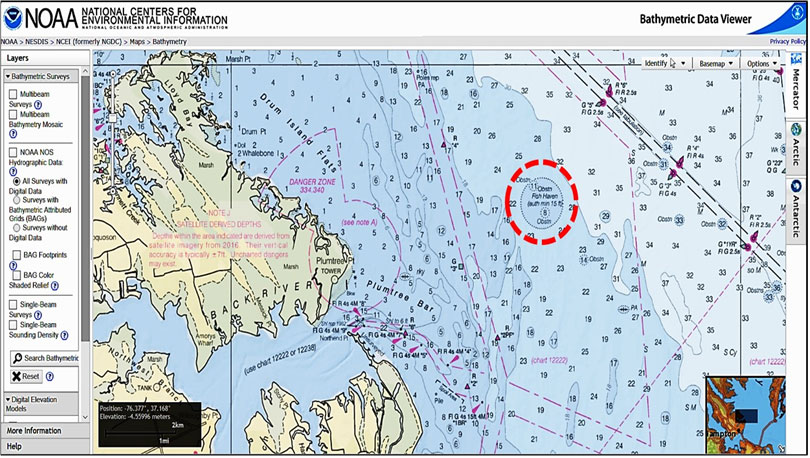
The Back River Artificial Reef is one of the more diverse and well-developed reefs in the VMRC program. The reef site is located 2.8 nautical miles at 019 degrees True from Back River Entrance Light 1BR, and is marked with a buoy as shown.
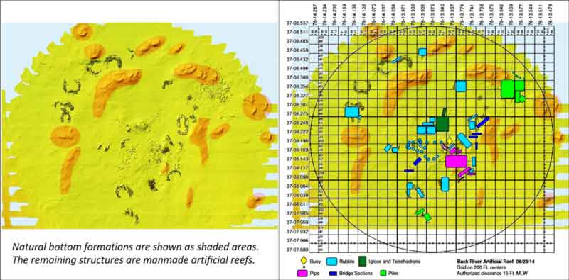
Calling up the fish haven side-scan sonar image reveals both natural formations and artificial reefs within and straddling the site boundary. Overlaying the grid system reveals more manmade reefs in the northwest quadrant than portrayed in the grid. VMRC advises that the reef data are being updated with information from new deployments and verification of older deployments as data become available.
Materials in this site include rubble, igloos and tetrahedrons, pipe, bridge sections, and piles. They’re placed in and among natural bottom formations. Each material of artificial reef has very rugged character. There are also significant variations in reef composition within general material categories. Rubble, for example, is highly variable, and could be anything from small concrete chunks to large concrete blocks to long concrete beams. Nevertheless, NOAA side-scan sonar data confirm that there is material where shown.
Fishing the Back River Reef
The semi-circle layouts you see visible in clusters throughout the site characterize a number of reefs in the VMRC system. There are multiple reefs at Back River that were placed using this type of configuration. Five reefs in the northwest quadrant of the site using variants of this reef form present interesting fishing possibilities. When current flows through the open side of the circle towards the reef structure, anchoring within the circle enables floating cut or live bait down-current to the reef in a chum line. The semi-circular pattern enables the anchored position to remain viable if there are swings in current direction during the tidal cycle, and the differing orientations of the open side of the reefs enables chum-line reef fishing of this complex during both flood and ebb current flows.
The natural formations in the northern third of the reef offer additional fishing options when chumming is not producing, or when the site is crowded. Plus, the natural formations are friendlier for light tackle jigging than are the more rugged manmade structures (which tend to lead to lots of snags and lost lures). Naturally, trolling over the reef structure is also a viable option at all times.
To learn about other reefs in the Bay, see the listings and links at Chesapeake Bay Fishing Reefs.
Author Wayne Young is the author of “Bridges Under Troubled Waters: Upper Chesapeake and Tidal Potomac Fishing Reefs.” You can find his Facebook page at Chesapeake Bay Fishing Reefs.
Sign up here to get the weekly FishTalk Chesapeake Bay and Mid-Atlantic fishing reports in your email inbox, every Friday by noon.