Anyone who loves Chesapeake Bay fishing should know about Cherrystone Reef, which is charted between depth contour lines and where bottom variations are prominent, even though it's not as famous as The Cell to its north. It is nevertheless well positioned and has a lot of reef structure with substantial vertical height.
Cherrystone Reef is about two miles northwest of the entrance to Cherrystone Creek. The charts show shelves, sloughs, and mounds in the immediate area. There is also the naturally deep channel to the west that is a Bay outlet along the southwestern shoreline of Cape Charles. These features provide multiple habitat zones and pathways for seasonal migration of prey and predators. How much did these factors influence reef location? We don’t know, but reef developers got the location right for marine habitat, fish, and fishermen.
Side-scan sonar images and sonar charts covering the fish haven and surrounding area confirm that ridges and sloughs run approximately north-south through and adjacent to the fish haven. Further west is the channel, with depths to 70-plus feet. There’s also a large natural reef southwest of the fish haven in a marked shoal area. What’s there is an eye opener. Check the book Rudow’s Guide to Fishing the Chesapeake for details about of fishing conditions throughout this area of the Bay.
The interesting bottom east of the fish haven starts along the shoreline with shallows having a defined western edge. Just past the edge is a series of holes oriented north-south bounded by a north-south underwater ridge on the west side that runs through the right center of the fish haven. The ridge drops off about six to seven feet into a north-south trough which is bounded on the west side by another north-south ridge. This ridge runs through the left center of the fish haven and drops off on its west side into another trough that runs along the western side of the reef site. The main body of reef material lies on the center and east side of this ridge. The trough along the west side of the fish haven is bounded by another elongated ridge that’s oriented north-northeast to south-southwest. There’s up to about 12 feet of vertical relief that drops off into bottom that slopes downward towards the west into the deep channel. These natural bottom features are enhanced by the artificial structures, providing opportunities for trolling, jigging, casting, and bottom fishing.
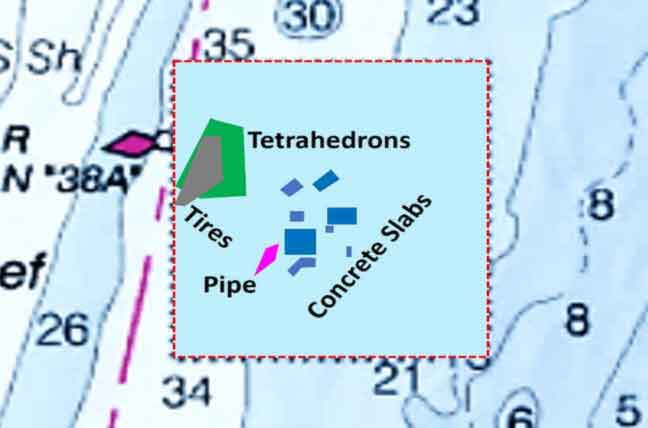
A grid drawing and satellite image from the Virginia Marine Resources Commission (VMRC) artificial reef webpages show the reef site layout. Placements include bridge decks from the Chesapeake Bay Bridge Tunnel, concrete blocks and pipes, tires-in-concrete, and concrete tetrahedrons and igloos. The reef structures are also within side-scan sonar coverage of the National Oceanic and Atmospheric Administration’s (NOAA) Bathymetric Data Viewer (BDV). Geographic coordinates can be extracted from the BDV, and are also published in the Virginia Artificial Reef Guide produced by the Virginia Saltwater Sportfishing Association (VSSA). Punching coordinates into an electronic chart as waypoints enables you to put your boat on the specific reef structures. My preference is to enter center points for specific reef materials on my chartplotter in advance, and then use the mark to position my boat where I want to anchor or drift to fish.
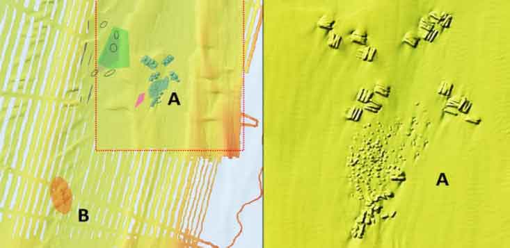
The reef layout graphic derived from VMRC images shows geometric shapes. These are approximate perimeters for specific materials. The actual configurations are irregular and don’t conform to the shapes shown. The NOAA BDV shaded side-scan sonar image shows the actual configuration of each reef deposit and enables correlation of reef material configurations with bottom features and geographic coordinates. An exception is the pipe reef that was placed in 2015. This was probably after the scan was taken. The tire-in-concrete modules may or may not be visible.
Generally, tire units are relatively low profile and from the side-scan images appear to have not fared well due to sedimentation. Tetrahedrons at this and some of the other Virginia fish havens also show evidence of sedimentation. These modules have a very small mass at the top, and there is a hint in research literature that this form of structure may contribute to sedimentation around the exterior. VMRC staff confirmed that reef files record concrete igloos in the site, but the date and placement location is not in the file. Therefore, they are not shown in the graphic. Igloos have substantially more mass in the top than tetrahedrons and are taller. In VMRC side-scan sonar reports for other reefs where both were used, igloos paint larger and more clearly defined images than do tetrahedrons. So, a best guess is that the anomalies are more likely igloos rather than tetrahedrons.
When first researching Cherrystone Reef, overlooked was an obstruction 1.8 nautical miles southwest of Cherrystone’s southwest corner. Taking another look, I found three piles of material consisting of 18 to 20 objects under the obstruction circle, in 35 feet of water. By appearance, these objects are concrete blocks or slabs that were deliberately placed in stacked piles. Since the obstruction is charted, it was likely reported in a Notice to Mariners or found during a NOAA survey. Yet, NOAA’s Automated Wreck and Obstruction Information System is silent about this site.
However, there is an entry about another placement of concrete materials west of the Cabbage Patch Reef. A tug reported dumping 23 large concrete blocks there in 1972, when in fact it was very possibly a deliberately constructed artificial reef without any known permit. (More about that reef in a future article). The southernmost pile in the west of Cherrystone ‘bandit” reef closely resembles the material, quantity of material, and “staircase” configuration of the block reef west of the Cabbage Patch. Best guess: the bandit reef was constructed in the early 1970s and probably without a permit, maybe even at the same time by the same tug and barge. This is great looking structure, and well worth adding to your jigging destination list.
To learn about other reefs in the Bay, see the listings and links at Chesapeake Bay Fishing Reefs.
Author Wayne Young is the author of “Bridges Under Troubled Waters: Upper Chesapeake and Tidal Potomac Fishing Reefs,” available at Amazon.com. You can find his Facebook page at Chesapeake Bay Fishing Reefs.
Sign up here to get the weekly FishTalk Chesapeake Bay and Mid-Atlantic fishing reports in your email inbox, every Friday by noon.