An old side-scan sonar image suggested a massive reef straddled the westside boundary of Hollicutts Noose Fish Haven northeast of Bloody Point on Kent Island. That’s where reef records recorded remnants of two bridges and a pier, other concrete materials, a cut up steel tugboat, and fabricated tire units. Shell piles, concrete cubes, and some of the first reef balls in Maryland’s Bay artificial reefs program are also in the fish haven. After outfitting my boat with an early Humminbird side-scan sonar back in 2009, checking out fish haven structure was on my striped bass prospecting list. Cruising north along the westside boundary, a bottom feature with a tire-unit profile appeared on the side-scan sonar screen. It was adjacent to a massive pile of reef materials which straddled the charted boundary. Two shell deposits and cubes I found by chance on the sonar aren’t recorded in reef files but are consistent with early artificial reef development in Maryland Bay waters, which included shell piles. That they were outside the reef’s boundary was a surprise.
Boundary anomalies at Hollicutts Noose are probably the result, at least in part, to navigational positioning error using Loran C. This hypothesis is reinforced by the fact that there are other state-sponsored artificial reefs and reef deposits in the Chesapeake Bay (and also the Delaware Bay) which geographically aren’t where they’re supposed to be according to reef permits and recorded positions of deployed materials. There are also several reefs which were put in the wrong spot. (See “Southern Maryland Mystery Reefs”).
Loran-C was a significant advance in navigation technology especially for ocean navigation, where electronic signals had the least interference from atmospheric and terrestrial effects. The technology had an advertised repeatable accuracy better than a quarter nautical mile. Readings were continuously available for fixing positions, a far cry from dead reckoning and periodic visual or celestial fixes. There was, however, the potential for interpolation error when transferring Loran line readings to paper charts. I recall being taught during navigation class at the Coast Guard Academy that there were also anomalies with Loran readings where landmasses could interfere with the electronic signals. Regardless, Loran C was pretty darn good. It produced very consistent readings and a boat operator could return to precise locations by following previously taken Loran line readings, even if the position was offset from the actual geographical location by signal interference. Nevertheless, the error factor means that positions of reef materials recorded with Loran-C could be a hundred or more yards away from their actual geographic coordinates.
GPS and electronic charts have changed the face of modern navigation, positioning, and of finding reefs. With GPS, side-scan, and down-looking sonar, a small boat can get within feet of bottom features that might have otherwise eluded discovery. And we’re discovering how far things are from where we thought they were.
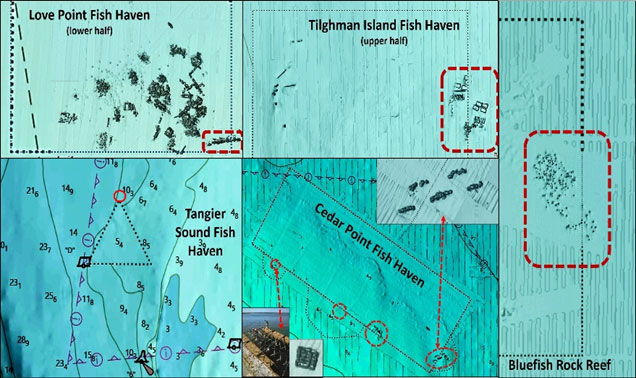
With this background knowledge, it wasn’t shocking that field observations using electronics and review of available data revealed anomalies in reported reef structure positions at some reefs. Materials that straddle or are just outside of official reef boundaries include the Love Point, Tilghman Island, Tangier Sound, Little Cove Point, and Cedar Point Fish Havens, as well as Virginia Marine Resources Commission’s (VMRC) Bluefish Rock Reef. Some of the out-of-bounds materials are substantial, as shown by Chart 1. NOAA in some cases also administratively expanded fish haven boundaries to include reef deposits found outside of permitted reef sites. But for some, namely the Love Point, Hollicutts Noose, Tilghman Island, and Tangier Sound Fish Havens and Bluefish Rock Reef, the boundaries haven’t been adjusted.
All of the aforementioned reefs except for Bluefish Rock Reef were established during the period when Loran C was used. Why a small quantity of material is outside Bluefish Rock Reef is unknown, but the reef deposit is adjacent to the boundary. On-scene conditions could easily have shifted deployment vessel positions just enough to produce this result, as happened during a deployment at Tilghman Island Fish Haven during my watch as reef program manager.
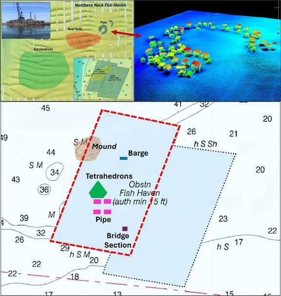
Loran C accuracy may also have contributed to a placement mishap whereby an Upper Bay reef deposit was put in the wrong place. Based on anecdotal information, we know now that demolition material from old bridges, about 4,000 cubic yards, was planned for placement in the Tolchester Fish Haven in 1988. The deployment vessel dropped a barge load of material alongside the buoy Department of Natural Resources (DNR) had placed marking the center of the fish haven. The material was assumed to be well inside the reef site boundary, but the buoy was later found to be off station. Why is unknown. The position was within the Loran-C maximum margin of error, or maybe the buoy was snagged by a passing commercial vessel or by winter ice and dragged. Regardless, reliance on the accuracy of a buoy position resulted in material placement about 400 yards east southeast of the fish haven center point and out of bounds. The DNR notified NOAA, which added the fish haven to its database in 1989 and to subsequent nautical charts.
VMRC’s trapezoidal shaped Northern Neck and Anglers Reefs are well offset from the permitted geographic position (Chart 2), so much so that all of the deposited reef material is outside of the permitted boundary. In fact, two overlapping reefs are charted for each. Upon finding boundary discrepancies through hydrographic surveys, NOAA charted the geographically correct reef boundaries as well as the “as-built” reef boundaries.
The Virginia State Reef system is well developed and well-documented. VMRC reef webpages include grid diagrams for each fish haven showing the type and location of reef materials. With this attention to detail and having consulted with the former VMRC reef manager regarding reef development, we know the two major boundary discrepancies resulted from the navigation technology error factor.
Located on the east side of the shipping channel, Northern Neck Reef (left inserts, Chart 3) is a popular fishing destination for boats out of the Little Wicomico and Great Wicomico Rivers. All four reef deposit areas at Northern Neck Reef are within the administratively added western trapezoid. The southwestern deposit consists of tetrahedrons that are partially covered with sediment. An area with reef balls just to the northeast fared better with less sedimentation. The smaller reef deposits northeast of the reef balls consist of nested concrete pipes and in past years have been a good place to float cut bait to the reef in a chum line for schoolies.
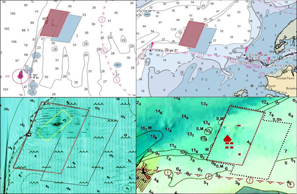
The most recent hydrographic survey at this writing for where Anglers Reef is located occurred during 1957, before the reef was established. So, the sounding data doesn’t show bottom masses that could be correlated with the VMRC reef grid for this site. As with Northern Neck Reef, all of the deposited reef material is outside of the permitted reef boundary but within the administratively drawn western trapezoid. Good fishing!
As well as being a regular contributor to FishTalk, Wayne Young is the author of multiple books detailing wrecks and fishing reefs in the Chesapeake Bay, Delaware Bay, and beyond. All are available at Amazon.com, and you can find his Facebook page at “Chesapeake Bay Fishing Reefs.”