The Delaware seacoast is rather short, yet the saltwater wreck and reef fishing opportunities along it abound. Through the treacherous Delaware Bay ships carry local, regional, and international maritime commerce to and from the historically busy port of Philadelphia and other river and bay area ports of call. The number of vessels that plied these waters through the years is huge, and wrecks, obstructions, and natural and artificial reefs offer a variety of sportfishing destinations for multiple species. Take for example bottom features that adorn the Delaware Bay Entrance shown on Chart 1 (numbers in parenthesis are from the Coast Survey’s Automated Wreck and Obstruction Information System).
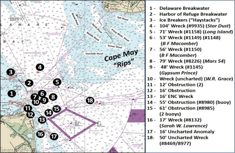
On the north side of the bay entrance, the Cape May “Rips” don’t rest in peace! Instead, Mother Nature continuously displays her physical energy here. Ocean swells, surface waves, winds, and strong currents interact with extensive shoals that rise up quickly from the bottom. The broad shoal area south of Cape May Point covers about the northern two thirds of the opening.
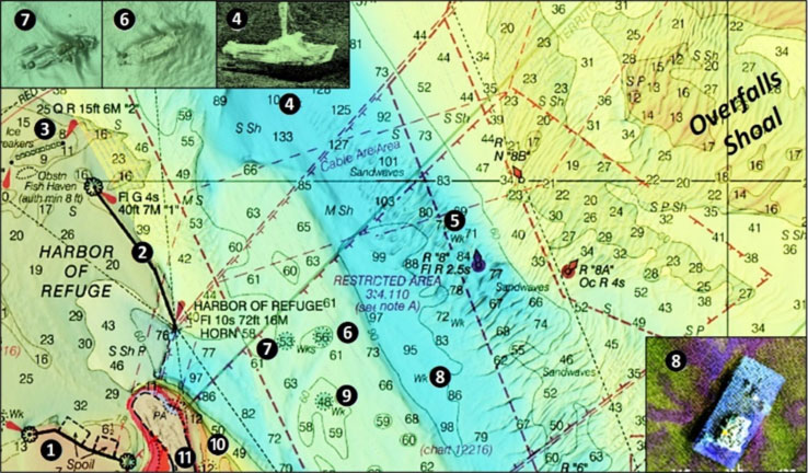
Overfalls Shoal towards the southern end is characterized by extensive sand waves (Chart 2). The graphic showing the bathymetry is a screenshot of Bathymetric Attributed Grid (BAG) Color Shaded Relief imaging from the online Bathymetric Data Viewer (BDV). My introduction to these rips came during an early 1960s family excursion from Sea Isle City to Rehoboth Beach. After departing the west end of the Cape May Canal in our family’s 30-foot Pacemaker sedan, my stepfather skirted the west side of Round Shoal. Over towards Middle Shoal to the southeast, the surface was confused. Swells coming in from offshore built into breaking combers. Although a fair-weather day, nature’s display was impressive, another waypoint for my nautical learning curve.
Below the shoals is a charted convergence zone for multiple shipping lanes. Per the nautical chart, “Traffic within the Precautionary Area may consist of vessels operating between the Delaware Bay and one of the established traffic lanes. Mariners are advised to exercise extreme care in navigating within the area.”
The Harbor of Refuge breakwater system (Sites 1 to 3 on the chart), although constructed to support commercial shipping, is a sportfishing destination. Delaware Breakwater (Site 1) was the first project of its kind in the United States. The eastern dogleg was the original breakwater. The westernmost dogleg was a protective icebreaker as winter ice was an issue well into the Twentieth Century. The center segment was constructed later to address a sedimentation issue.
The loss of 10 sailing vessels with cargos of coal that were anchored behind the Delaware Breakwater during one particularly bad year led to the construction of the National Harbor of Refuge (Site 2) and its icebreakers (Site 3). The breakwater’s massive rock structure and scour holes at each end provide extensive marine habitat and foraging opportunities for predators. The structure also creates a lee to fish when conditions on the north side are sloppy. Currents rip around the ends, and the southeastern end takes direct hits from ocean swells making for turbulent conditions there.
Northwest of the Outer Wall at Site 3 are charted icebreakers known locally as “haystacks.” These stacked and fitted stone piers were placed as part of the Harbor of Refuge project. All were above the surface, but some have since subsided and are now at or just below the surface. In addition to those charted, there were four more that ran in a line between the northeastern most haystack and the northwestern end of the Outer Wall. We believe they were removed when the Cape May–Lewes ferry route was established during the mid-1960s. Scattered rock remnants of three piers remain.
Northeast of the breakwaters at Site 4 is the wreck of the 90-foot fishing vessel Star Dust. It sank in 1992 in coordinates 38’50.642N x 75’04.514W, with a least depth of 104 feet. Sonar images taken during a 2013 hydrographic survey show the vessel upright and intact as depicted by the insert in Chart 2. Site 5 is the distributed wreckage of the steamer Long Island which was lost in 1936 at coordinates 38’49.595N x 75’02.568W. Divers inspecting the wreck during a 1993 hydrographic survey found scattered debris including a metal railing, wooden beams, one large and one small compartment, and a large anchor shaft. The compartments rose about 15 feet from the bottom. BAG imaging for the site shows sand waves, suggesting that the wreckage has sanded in.
Northeast of Cape Henlopen at Site 6 are remains that may be from the steam vessel B. F. Macomber at coordinates 38’48.750N x 75’04.422W. Site 7 is the B.F Macomber hull at coordinates 38’48.779N x 75’04.069W. This was a wooden 138- by 22-foot vessel that was owned by a fisheries company. It sank following a collision in 1946. At Site 6, divers inspecting the wreckage during the 1993 hydrographic survey found scattered debris consisting of wooden ribs, coal, and bricks. At Site 7, the debris consists of propulsion gear, scattered wood beams and planks, a hawser, a windlass, and several large metal compartments that rose about seven feet from the bottom. These are sites to check for tautog and sea bass and flounder around the edges.
East northeast of Cape Henlopen at Site 8 is the 79-foot wreck of the crane barge Mars-54 which sank in 1979 in coordinates 38’48.486N x 75’02.901W. The crane lies flat, bent, and silting in about 550 yards north northeast of the wreck, which rests upright on the bottom. A hydrographic survey produced a quality multibeam sonar image including the lower right corner insert on Chart 2. Small wrecks sometimes hold a lot of fish, so this is another spot to check for tautog and sea bass.
Moving inshore, look at Site 9 for the 48-foot-deep wreck of the 357-foot steel barge Gypsum Prince at coordinates 38’48.266N x 75’04.043W. This barge sank in 1942 with its cargo and divers found extensive battered remains that suggest it was demolished by explosives. The wartime practice was to clear coastal waters of wrecks and obstructions or to establish minimum clearance depths over them by cutting off superstructure and gear with wire drags or by demolition. Although a rugged wreck and a hook-snagger, it is well suited to attract and hold tautog and sea bass.
Just offshore on the east side of Cape Henlopen at Site 10 is an uncharted wreck about 150 yards offshore in coordinates 38’47.790N x 75’05.195W. It’s just northeast of a charted 12-foot obstruction (Site 11). According to hydrographer markup notes on the survey report, the wreck wasn’t charted due to its close proximity to other obstructions. The wreck is about 200 feet long and 45 feet wide, and is oriented northwest to southeast, as shown on Chart 3. How much vertical relief exists is uncertain, but work this one for flounder for sure. It was identified in 2012 as the W. R. Grace by the University of Delaware. The ship grounded with a cargo of barrels and was lost during a hurricane in 1889. It is thought to have been sanded in and then uncovered sometime after 2007.
BAG imaging for Site 11 suggests two features at coordinates 38’47.739N x 75’05.221W. A faint rectangular shape about 120 feet in length and 20 to 30 feet wide has the appearance of a sanded-in barge wreck. Immediately south are a large pile and small pile of objects described as “rectangular rocks or slabs that rise three to four feet off of the bottom.” All of this might be a barge that foundered, sank, and spilled a load of rock for one of the breakwater projects. This feature is about 100 yards offshore. Site 12 at coordinates 38’47.540N x 75’05.083W is another pile of unidentified material that’s about 200 yards offshore, 75 feet long, 50 feet wide, with as much as a six-foot rise off the bottom.
Site 13 marks a wreck at coordinates 38’46.523N x 75’04.251W. Reports state “The wreck appears to be ruins of a barge measuring approximately 27 meters by 6 meters oriented 118 degrees with apparent cargo mounds on the northeast side.” Site 14 at 38’47.227N x 75’03.485W, and Site 15 at 38’47.344N x 75’02.594W, are sunken construction buoys lying on their sides.
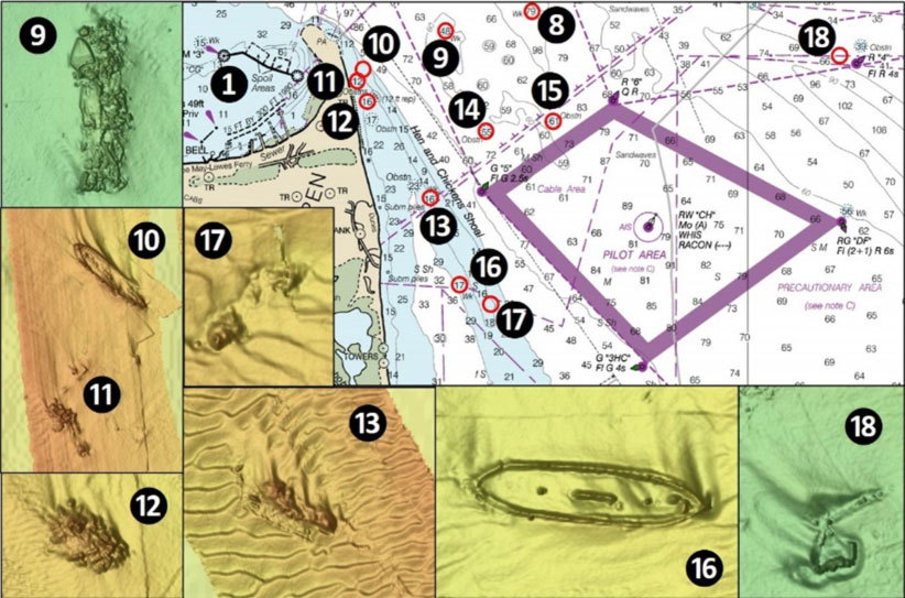
Just off the lower southwest end of Hen and Chicken Shoal at Site 16 lies the 17-foot-deep wreck of the wooden schooner Sarah W. Lawrence at coordinates 38’45.627N x 75’03.842W. This four-masted, 217- by 45-foot schooner sank in 1909 with a load of coal. The wreck was reported as broken up and scattered with a few ribs and planks showing and a vertical height of five feet off the bottom. BAG imaging from 2007 shows the vessel’s gunnels more or less intact with much of the interior infilled with sediment. The wreck site looks good for flounder, sea bass, and any other finfish that happen to swim by. Nearby at Site 17 is an uncharted anomaly on the eastern edge of Hen and Chicken Shoal at coordinates 38’45.407N x 75’03.402W. Three objects in a scour hole are shown by BAG imaging. The configuration suggests an uncharted wreck.
Site 18 marks uncharted wrecks that were found during a 1992 hydrographic survey at coordinates 38’48.009N x 74’58.813W. One feature is thought to be a crane. The other feature is about 60 feet long and 22 feet wide. Divers found a metal wreck oriented east-west with some ribs showing but deck plating gone. BAG imaging shows the wreck mostly covered with sediment. By all appearances, this was a barge carrying a crane and deck cargo.
Between the shipping traffic and the rough nature of the seas in these areas, only venture out into the bay entrance in a well-equipped, good sea boat with full safety gear. Always file a float plan, and pay attention to surface and weather conditions, and run back in before operating conditions challenge your boat’s capabilities.
- By Wayne Young, author of “Bridges Under Troubled Waters: Upper Chesapeake and Tidal Potomac Fishing Reefs,” “Chesapeake Bay Fishing Reefs, Voyage of Discovery,” “Phantoms of the Lower Bay,” and “Hook, Line, and Slinker.” All are available at Amazon.com, and you can find his Facebook page at Chesapeake Bay Fishing Reefs.
Sign up here to get the weekly FishTalk Chesapeake Bay and Mid-Atlantic fishing reports in your email inbox, every Friday by noon.