DelMarVa recreational fishermen prospecting where the Delaware River meets Delaware Bay and down the Bay’s Delaware coastline have some interesting structure to target between Rays Ditch and Roosevelt Inlet. We’ll start our structural scouting mission downriver of Rays Ditch outlet at Site 3 on the chart, where there’s an unidentified 16’ least depth wreck on the Delaware side of the ship channel. However, the DEM data layer is unrevealing, suggesting that little is left there.
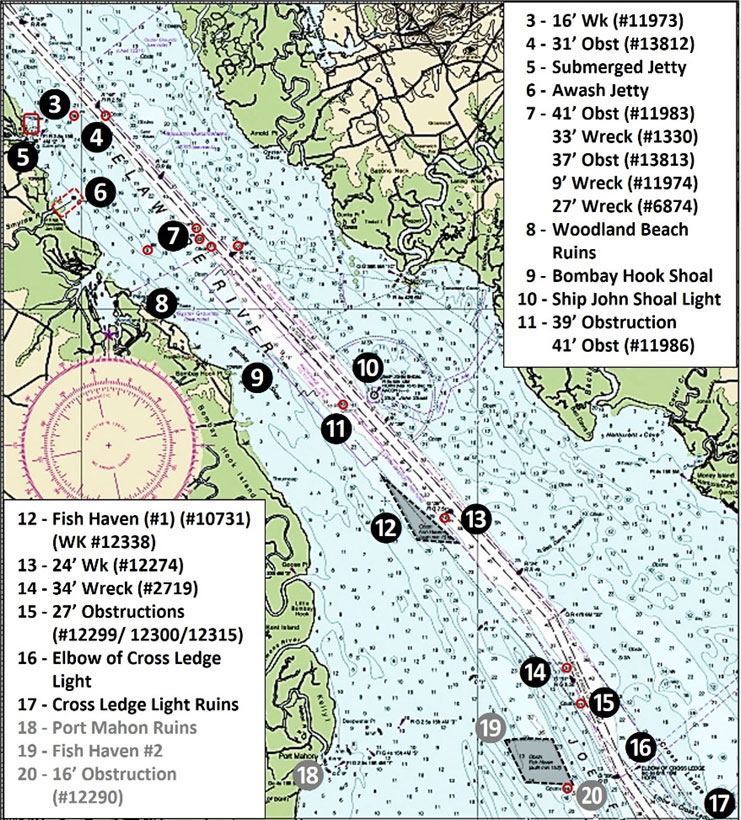
A charted 31’ least-depth obstruction marked as Site 4 is at coordinates 39'23.823 x 75'29.387. Whatever is there lies along what appears to be a long line of dredge material on the northeastern side of the ship channel. Although the vertical relief is uncertain, DEM color relief shading suggests at least several feet of rise off of the bottom. Sand waves are charted in the area northeast of the ship channel between Buoys R “46” and R “44.”
Along the Delaware shoreline at Collins Beach there’s a nice boat ramp, but be careful entering the mouth of Cedar Swamp. The area at Site 5 is charted as foul for good reason—submerged rocks and deteriorated pilings that date to before 1900. A 1986 hydrographic survey documented by National Ocean Survey found that “The jetty runs north from the above position to shore and bends around the point in the area of Collins Beach. A small L-shaped groin exists at the point. The area inshore of the jetty is gutted with pilings which are visible at low tide; some portions of the jetty from midpoint to shore uncovers with rocks. The jetty, from its midpoint to the offshore end, is completely submerged and is considered very dangerous.” The submerged jetty was visible in a 2007 Google Earth historical image at coordinates 39'23.493 x 75'31.393, immediately south of the rock shoreline protection at Collins Beach. How much remains today is uncertain.
At the entrance to the Smyrna River at Site 6 are two heavily weathered old inlet jetties. According to U.S. Army Corps of Engineers records, this channel protection project was constructed in 1939 and deauthorized in 1986. The project consisted of an 803’ north jetty and a 2,000’ south jetty, both of which run towards the northeast. The structures consist of two parallel, rock-filled, timber crib jetties. Portions of each cover and uncover, especially towards the outer sections. The DEM data layer shows a drop-off just off the south jetty. Check here and around the end of the outer portion of the south jetty for striped bass. For largemouth bass anglers, the river and larger feeder creeks here are navigable way upstream. Several bridge crossings provide piers to target.
Site 7 marks five features west and northwest of Buoy R “42.” Of these, the 33’ least-depth wreck at coordinates 39'21.379 x 75'27.022 is the more substantial. The feature is recorded in a 1970 survey as a 50’ LCM, so it’s been there for at least 50 years. A nine-foot wreck at coordinates 39°21.155 x 75°28.343 was uncharted when found during a 2001 hydrographic survey, and displays as a mound in the DEM data layer. Neither the 41’ obstruction nor the 37’ obstruction stand out. The southwest side of the ship channel becomes very rugged from just upriver of the 41’ obstruction all the way downriver to Ship John Shoal. Just northeast of Buoy R “42,” look for a 27’ wreck at coordinates 39°21.215 x 75°26.044. A 1986 hydrographic survey found “a large mass of corroded metal.” The wreck was found again during the 2001 hydrographic survey and there’s a slight mound displayed by the DEM data layer. So, whatever is there now appears to have less vertical relief.
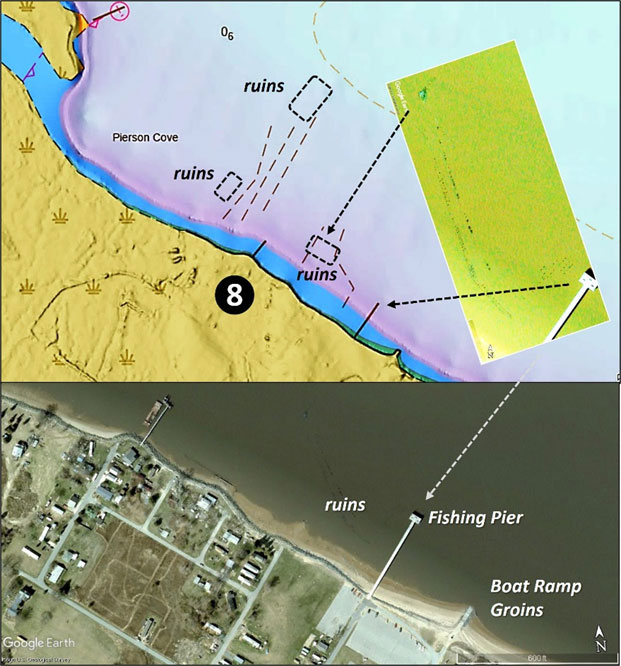
Southeast of the broad outlet of Duck Creek is the town of Woodland Beach where there are extensive pier ruins (Site 8). The town was once home to a major beach resort with hotels, restaurants, bars, an amusement park, and roller coaster. The resort was wiped out by a hurricane and 10’ storm surge in late 1878. Many structures that were rebuilt were wiped out by a nor’easter and storm surge in 1914. The pier ruins in Pierson Cove are the remnants of the steamboat landings. Extensive visible broken off pilings extend out but there are more submerged ruins further offshore, as seen on Chart 2. Be careful operating and fishing in this area. Today, there’s a substantial fishing pier here and a concrete public boat ramp which falls bare at low tide. The ramp is protected on both sides by rock groins, but there’s no protection to shelter it from waves.
Southeast of Woodland Beach, Bombay Hook Shoal (Site 9) has interesting bottom contours. The shoal ridgeline appears to be of geologic origin rather than depositional. The submerged point is only a foot or two below the surface. At its outer end, the bottom slopes downward and then drops off to about 25’. There’s a small bowl or shallow ravine on either side of the outer end. The configuration positions the submerged point to interact with tidal currents and also can draw baitfish into the bowl and around the end of the submerged point. This is a setup for striped bass when current is running.
East southeast on the north side of the ship channel is one of the prime upper Delaware Bay fishing destinations, Ship John Shoal Light (Site 10). The shoal is named after the ship John which, on Christmas Eve 1797, grounded on the shoal. The passengers and crew were safely removed and the cargo was salvaged, but the ship was a total loss. The iron caisson style “fireplug” lighthouse is nestled between two large icebreaker rockpiles. Current interactions with the icebreakers make for some interesting fishing conditions. Anchoring is difficult due to current and bottom conditions, and many fishermen use grappling anchors here. This is known as a nighttime fishing hotspot, but given its configuration, try casting for stripers any time current is running. Historically this was also a good weakfish spot.
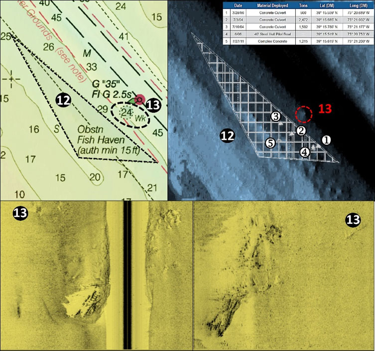
Site 11 across the ship channel from the lighthouse marks a 39’ least-depth obstruction and a 41’ least-depth obstruction. The DEM data layer shows small masses at each location. Now we come to Delaware State Fish Haven #1, Site 12. The reef program layout drawing superimposed over a highly processed DEM sounding data layer shows a natural ridge with multiple high points (Chart 3). Reef structures are in the southeastern corner on the channel side of the ridge. When prospecting the reefs, don’t forget the ridge. Also check out the unidentified 24’ least-depth wreck (Site 13) outside but near the middle of the fish haven’s northeastern boundary. This danger to navigation was found during a 2001 hydrographic survey and several side-scan sonar images (bottom images) show substantial scattered debris.
The remains of a sunken fishing vessel (Site 14) are on the southwestern side of the ship channel just northwest of Buoy G “31.” The 34’ least-depth wreckage, charted in 1984, is described by divers to be “wood and metal debris on a gently sloping bottom.” The DEM data layer shows a low mound. Look for a cluster of obstructions southwest of the buoy along the ship channel edge at Site 15.
Before turning into Port Mahon, check out Elbow of Cross Ledge Light (Site 16). A fireplug-style lighthouse sat on a cast iron caisson originally excavated into the bottom using a pneumatic process, then the caisson was filled with concrete. It replaced Cross Ledge Light, now in ruins several miles to the northeast (Site 17). The caisson platform was completed in 1907. The lighthouse wasn’t protected by a rock icebreaker, which might have saved it from its future fate; it was struck glancing blows several times by ships navigating in fog, and contemporary reports say that the lightkeepers slept with their lifejackets on during foggy nights. The Coast Guard automated the light in 1951 after it was substantially damaged by a strong storm, then in 1953 a large ore ship inbound in heavy fog with an inoperative radar collided with it. The upper two-thirds of the masonry structure was knocked into the bay creating a rubble pile that is fished today. The rest of the masonry structure was demolished and replaced by the existing skeletal steel tower with a light. Both lighthouse foundations are fishing destinations, but be prepared for the strong currents as well as changing weather and surface conditions.
- By Wayne Young. As well as being a regular contributor to FishTalk, Wayne Young is the author of multiple books detailing wrecks and fishing reefs in the Chesapeake Bay, Delaware Bay, and beyond. All are available at Amazon.com, and you can find his Facebook page at “Chesapeake Bay Fishing Reefs.”