Recent surveys by the National Ocean Service (NOS) collected hydrographic data needed for chart updates to provide improved sonar data coverage for the Upper Bay, from the Bay Bridge to north by northwest of Love Point. Processed sonar data were added to the NOAA Bathymetric Data Viewer’s (BDV) Bathymetric Attributed Grid (BAG) Color Shaded Relief data layer. Both the BAG and Digital Elevation Models (DEM) data layers can be placed under a see-through Electronic Navigational Chart (ENC). However, learning when to and how to fish specific hotspots is fundamental to successful catching. The when and the how aren’t revealed by online sonar data—although careful assessment of sonar images sometimes produces clues. As a courtesy to the guides, charter captains, and recreational fishers who have shared their knowledge with me, lessons learned from them stays on the boat unless they authorize sharing. With this proviso, let’s look at the features NOS surveyors found off Love Point.
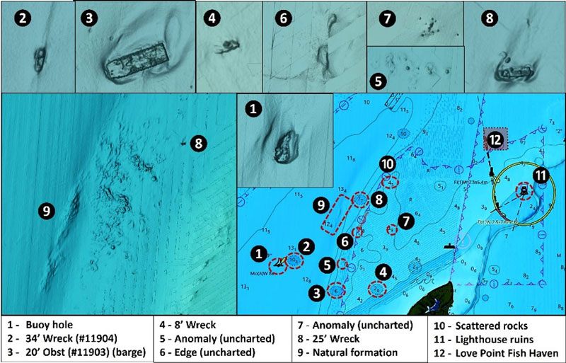
Site 1 is a buoy hole under the Upper Chesapeake Lighted “LP” Channel Buoy. Although fish may occasionally be found hanging out around a buoy, the better spot to try is the scour hole around the concrete block sinker. Buoys in areas where there are strong currents and high waves yank the sinker around on its heavy chain, disturbing the sediment. Strong current carries suspended sediment away and scours around the sinker. The result is sometimes a huge scour hole where predators can wait for the current conveyor belt flowing over the edge to disorient and deliver bait. For LP Buoy’s sinker, the hole is about 80’ long and 60’ wide. That’s not a huge target, but there’s no problem finding it since the buoy marks the spot. Although the depth of the hole below the surrounding bottom isn’t charted, I’m guessing on the order of five feet or so given how prominent it displays in BAG Color Shaded Relief.
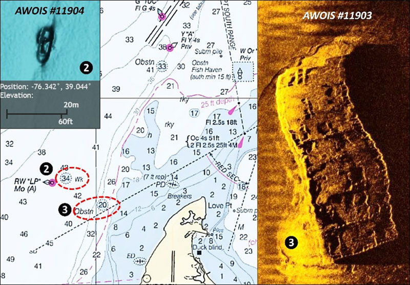
About 400 yards northeast of the buoy at coordinates 39'02.641 x 76'20.521 is a 34’ least-depth small wreck (Site 2). It was found by the U.S. Army Corps of Engineers during a 1999 hydrographic survey using multibeam sonar. It measures about 50’ long and is oriented north-northeast to south-southwest. There’s a light scour trailing off towards the northeast. A large barge wreck is at Site 3, coordinates 39’02.278 x 76’19.895. Records show that this feature was found during a 2001 hydrographic survey and was thought to be a container. It’s actually a steel barge that measures about 150’ by 35’. Many deck plates are missing and others have large holes as shown by a high-definition side-scan sonar screenshot (right side of Chart 2) taken and shared by Nick Garrott of Sonar Kings. The barge sits in a scour that trails off towards the northeast. This indicates that the dominant bottom current flowing over this wreck is during currents produced by rising tides. Off to the east-northeast is a small, unidentified but charted wreck at Site 4 in coordinates 39’02.299 x 76’19.260 with a least depth of eight feet. Look for uncharted anomalies marked as Site 5. By appearance, they may be rocks or outcroppings. Site 6 marks a high point at the southern end of a natural edge which is offset to east of the edge contour line, and Site 7 looks like a cluster of rocks.
Site 8 marks an unidentified 25’ least depth wreck at coordinates 39’03.354 x 76’19.510. It’s oriented east-west, measures about 50’ long, and sits in a scour which trails towards the northeast. Southwest of the wreck on either side of the ancient Susquehanna Riverbed are natural formations marked as Site 9. It’s a broad area of rugged bottom about 800 yards long and 300 yards wide. By appearance this resembles a hard outcropping. The westside formation is an elongated edge about 400 yards long and oriented north northeast-south southwest. By appearance, it was the top of a ridge along the west side of the riverbed. This whole area has some of the best-looking bottom in comparison to the surrounding areas.
Site 10 off the northeast is a broad area of very widely scattered rocks centered at coordinates 39’03.562 x 76’19.086. There are some additional rugged spots with scattered rocks and edges further north and northeast. When armchair scouting these features, you’ll have to zoom in to get them to stand out against the blue-green palette that the BDV is currently using. Try drifting across these areas and jigging for stripers. I’ve also had white perch hit jigs on these bottoms.
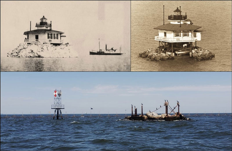
Back in the day of really cold winters, ice rafted up high on Love Point. The Love Point Lighthouse was threatened by damage or loss by ice which piled up against its screwpile foundation as shown by Image 1 and historic Coast Guard picture inserts. Because of this, the lighthouse was protected by an artificial rock island which served as an icebreaker. Eventually, the lighthouse was removed and replaced by a fixed light. The lighthouse foundation ruins and rocks are a well-known fishing hotspot. But here’s a surprise: “BAG” Color Shaded Relief shows two small subsurface rockpiles about 75’ feet to the southeast.
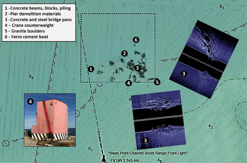
North of Love Point is Love Point Fish Haven (Site 12). It was included in a second 2023 NOS hydrographic survey which looked east and north of Love Point. There have been considerably more materials deposited there since my time as reef program director. A partial correlation of material deposits is possible using the BDV’s Color Shade Relief data layer (Chart 3) and side-scan sonar images I took after the initial deck pan deposit. Look for a large crane counterweight at coordinates 39'03.973 x 76'17.370, a ferrocement sailboat which was deployed during 2023 is nearby, and the granite rockpile at the southeast corner straddles the reef boundary. The other deposits are demolition materials of opportunity. This fish haven is on my list to revisit and image with my new Humminbird MEGA+ side-scan GPS combo.
As NOS continues to update area hydrographic surveys, more “secret” hotspots which were previously closely held will be revealed. But once posted online for anyone to find, the proverbial cat is out of the bag. As noted, the “where to” of fishing needs to be matched up with when and how to fish each specific spot. Checking FishTalk past issues and books by FishTalk Angler in Chief Lenny Rudow and contributors helps fill in the gaps. But it still takes time on the water to put it all together. Charters and guided trips enable focusing on fishing detail without having to operate the boat or serve as mate. Check the Charter Guide in FishTalk for quality charter captains and guides.
-By Wayne Young
As well as being a regular contributor to FishTalk, Wayne Young is the author of multiple books detailing wrecks and fishing reefs in the Chesapeake Bay, Delaware Bay, and beyond. All are available at Amazon.com, and you can find his Facebook page at “Chesapeake Bay Fishing Reefs.”