Mobjack Bay Reef, an elongated site tucked away inside the Bay, is one of the Virginia Marine Resources Commission (VMRC) artificial reefs. Located about 2.75 miles southwest of New Point Comfort, the location offers a lee during northeasterly and southwesterly winds. Nearby bottom features provide a range of fishing opportunities. Due north at Pepper Creek Light “2P,” there’s an underwater ledge with a steep drop-off. Another submerged ledge protrudes south along the west side of Pepper Creek. About a mile to the southeast of the site’s southeast corner, another submerged ledge juts out into deep water. From sonar charts, a swale on the northwest side of this ledge is a place to check for bait swept in and piling up during an ebb. Be sure to check out Fishing Mobjack Bay and the Piankatank, for more information on fishing in this entire area, but meanwhile let's take a close-up look at the reef itself.
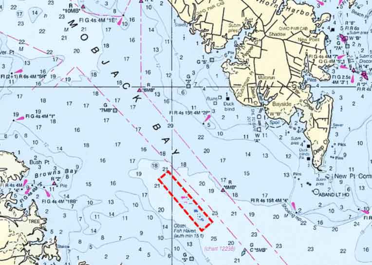
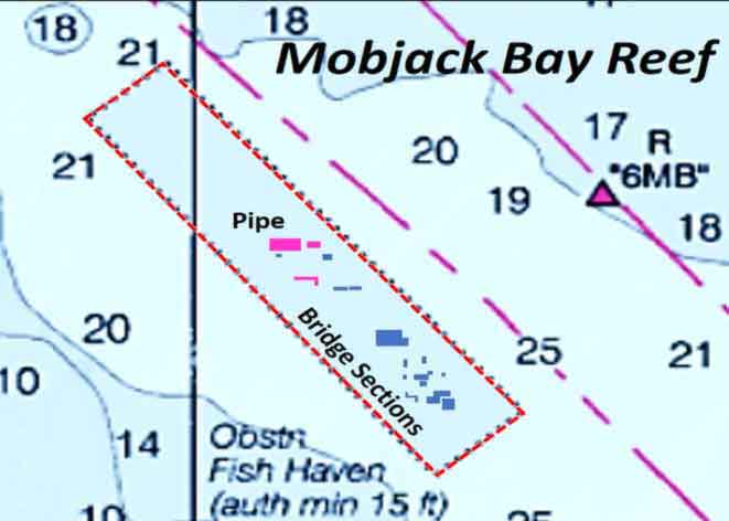
Materials deployed at the Mobjack Bay reef site include concrete pipe, portions of the Lord Eltham Bridge, and pile caps and bridge sections. The concrete pipe was placed approximately in the center of the reef. The bridge sections and other demolition materials are in the southeastern third of the site. Materials are located about where shown on the reef layout drawing. Don’t be misled by the geographic shapes shown on VMRC grid and Geographic Information System (GIS) webpages. The shapes approximate the perimeter of individual reefs which don’t conform to the simple geometric shapes.
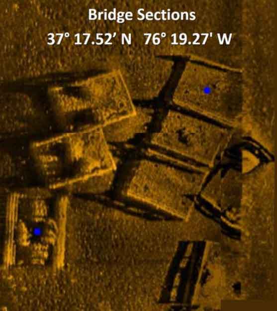
This fish haven is one of the VMRC reefs that’s outside of side-scan sonar coverage available on the web from the National Oceanic and Atmospheric Administration (NOAA). VMRC does, however, have a sonar report. Side-scan images were taken a decade ago with a towed array sonar transducer. The sonar reports include individual-structure-specific side-scan image excerpts.
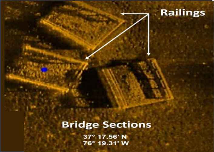
Scoping this reef site was my first attempt to correlate VMRC sonar report data with the VMRC GIS shapes. Interpreting the images and data provide an example of what can be learned using this resource. The side-scan images for this reef are rather well defined, and features such as railings on bridge sections are clearly visible, flagged by sonar imaging shadows. Where the towed array sonar is off-center from the structure, the angle of the sonar signal creates a shadow behind the structure. Both the railings and the shadow are clearly visible. However, sometimes only a sonar shadow is distinct enough to draw attention. Structure type identification and geographic coordinates are also listed for a blue spot within each image.
Could these images be pieced together to form an area-wide montage? The answer is no. The images are a puzzle without all the pieces. My effort to create an area-wide montage to show actual reef configurations was unsuccessful and frustrating. However, it was possible to piece together a few images here and there that give a sense as to reef material character and configurations. As it turns out, the sonar report for this reef had more pieces that could be stitched together than for other reefs with similar reports.
The Mobjack Bay Reef site materials are very rugged. Some are laid in patches. Others are smeared closely together on the bottom. Some layouts approximating geometric shapes. For example, semi-circle and horseshoe reefs are characteristic of many reefs that were put in during former Reef Manager Mike Meier’s tenure; the Mobjack Bay Reef includes these forms. The idea for semi-circular reefs was to create places where a boat could anchor up and float a chum line and bait or live-line back to the reef. The various semi-circles have difference orientations which enable use of this technique as on-site environmental conditions vary.
There are some real nifty nooks and crannies to fish, although fishermen are going to have to go there and find them with their electronics. To help do that, these coordinates showing the approximate center point for the material in each composite image are listed. Good luck, and good fishing!
To learn about other reefs in the Bay, see the listings and links at Chesapeake Bay Fishing Reefs.
Author Wayne Young is the author of “Bridges Under Troubled Waters: Upper Chesapeake and Tidal Potomac Fishing Reefs,” available at Amazon.com. You can find his Facebook page at Chesapeake Bay Fishing Reefs.
Sign up here to get the weekly FishTalk Chesapeake Bay and Mid-Atlantic fishing reports in your email inbox, every Friday by noon.