There has been research which suggests that a patch reef (one that is spread out across an area with many distinct small reefs), tends to be more biologically productive than a large single reef. Even so, fish tend to move around, fish that school congregate as a species, and growth of marine organisms and foraging conditions vary across a reef complex due to varying environmental conditions below the surface. So, don’t be surprised if a reef has sweet spots—the secret is learning where they are. Meanwhile, a large mass of reef structure has more biological carrying capacity than does a small reef. But tight concentration of structures are easier to find for fishing, and patch reef formations and smaller satellite reefs near larger structure help keep the reef from being fished out. Thus, a mix of all of the above is often a good approach to reef-building. Characteristics of many artificial reefs developed under the authority of the Virginia Marine Resources Commission (VMRC), Occohannock Reef (37’34.38’ x 76’00.68) includes it all: a mass of reef structures, main and satellite structures, and a combination of reef layout formations.
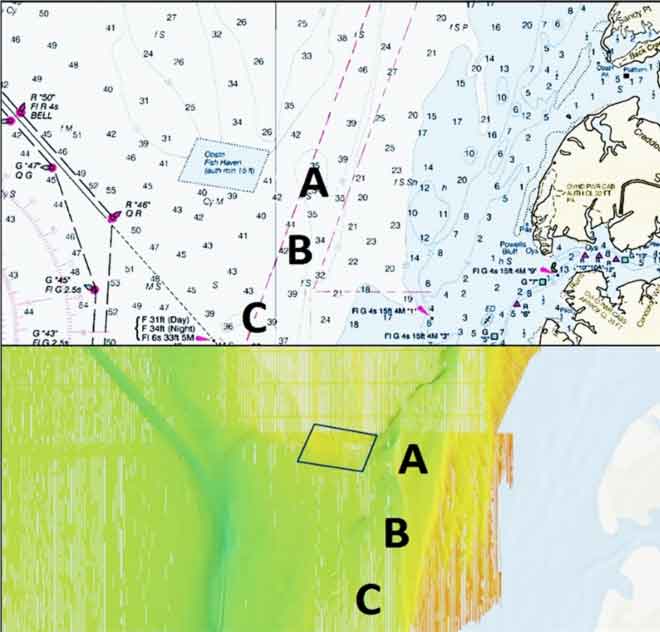
Located in the main stem of the Bay off Occohannock Creek on the Eastern Shore of Virginia, the reef’s shape is a parallelogram. Early reef structures were established during the Loran-C positioning era. Three areas along this anomaly labeled as locations A, B, and C, while not prominent or charted as a navigation issue, nevertheless offer subtle edges, depressions, and irregularities. Off to the west and southwest are the Rappahannock Shoal dredged channel and the natural deep-water old riverbed it connects to.
Several natural bottom formations near the reef site shown as locations A and B are depressions that don’t jump out on nautical charts and can be easily missed. At location A, there is an edge that drops off between eight to 10 feet. The depression extends westward from the edge. The depression shown as location B only drops down a few feet. Both appear to have a slightly rougher texture than surrounding bottoms.
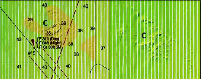
Sounding data at Location C shows four to five feet of vertical relief. While relatively subtle, these three areas are distinctively different than surrounding bottoms, which is the characteristic that caught my attention while working through BDV images. Perhaps it catches the attention of predator species as well. If fishing over on the eastern side and the Occohannock artificial structure isn’t producing, give these natural features a try.
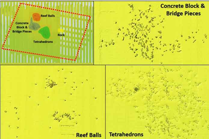
VMRC’s reef grid drawing doesn’t exactly align with the reef as charted on nautical charts. This is due at least in part to scaling issues associated with the grid. There are four reef sites within the fish haven. Each is distinct enough to enable easy correlation with the grid data. Side-scan sonar images from the National Oceanographic and Atmospheric Administration’s (NOAA) Bathymetic Data Viewer (BDV) provide full coverage of about half the fish haven and partial coverage for the remainder. Three of the reefs are shown in the scans. The last reef that was placed, made of rock, is not shown. The sonar data may predate rock placement. A sonar report is available on the VMRC website, but it doesn’t show the rock either.
The first reef deployment consisted of 1200 concrete tetrahedrons. Then 120 Reef Balls were purchased and deployed as the second reef in 2004. A third reef consisting of bridge demolition materials was placed during 2006. It consists of 2000 tons of concrete block and bridge parts. The fourth reef, about 1800 tons of rock, was placed in 2011. The latter should be a fairly substantial reef based on the quantity of material that was placed.
The tetrahedron reefs appear to have not fared as well as the Reef Balls and concrete block and bridge parts reefs—many appear as mostly buried. Tetrahedrons at the Northern Neck Fish Haven have a similar profile in relation of other reef types there. The tetrahedrons were some of the earliest reefs put in, so they have been subject to potential effects of sedimentation longer. That said, the more pronounced sonar profiles of other reef forms may be related to their greater mass, shape, and height, especially with respect to the concrete materials of opportunity. Also, the design of Reef Balls that were used, which are approximately similar in height to tetrahedrons, helps maintain water flow around and through the modules and can help reduce the effects of sedimentation. So, is there something about tetrahedron design that works against it?
During an internet search, one study popped up that suggests that tetrahedron frames may reduce the probability of sedimentation inside a module. But the shape may also change the direction of current flow so as to dissipate energy and increase the potential for sedimentation around the outside. The BDV side-scan images are not conclusive by themselves regarding performance of the different reef types at this fish haven, but what is depicted suggests that comparative research into the performance of different reef forms could inform future reef development decision-making. Regardless, there is some very nice reef structure inside the Occohannock Reef boundary that has been there long enough to have substantial marine growth. As with any artificial reef structures, don’t use the most expensive tackle when floating above it. If anchoring, be careful not to get so close as to get hung up.
See our Chesapeake Bay Fishing Reefs Guide to get the lowdown on other mad-made wreck and reef hotspots in the Bay, plus a few in the ocean off the DelMarVa coast.
-By Wayne Young, author of “Bridges Under Troubled Waters: Upper Chesapeake and Tidal Potomac Fishing Reefs.” His new book, “Chesapeake Bay Fishing Reefs, Voyage of Discovery,” was just recently released this winter. Both are available at Amazon.com, and you can find his Facebook page at Chesapeake Bay Fishing Reefs.
Sign up here to get the weekly FishTalk Chesapeake Bay and Mid-Atlantic fishing reports in your email inbox, every Friday by noon.