East Ocean View Reef, originally known as ODU College Reef, or ODU Reef, was sponsored by The Institute of Oceanography at Old Dominion University (ODU). The reef’s purpose was to support student study of fish breeding and feeding habits. Construction was completed in mid-1968. The Coast Survey’s Automated Wreck and Obstruction Information System (AWOIS), a National Oceanographic and Atmospheric Administration (NOAA) resource, recorded the reef establishment. The plan was to construct the reef in two sections. Each was to be 333 yards long, 28 yards wide, and 50 yards apart.
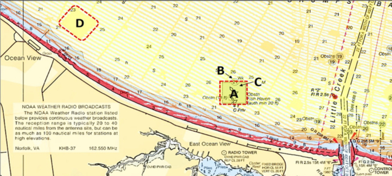
Four hundred junked automobiles were planned for each section. Four rows of cars would be stacked five cars high and bound together with steel cables. Concrete blocks would be placed in rows at each end to anchor the structure. A vertical height of six feet off the bottom was estimated, although the permit limited vertical rise from the bottom to five feet. The reef was later absorbed into the Virginia Marine Resources Commission (VMRC) artificial reef system. The reef site, location A, was expanded in size with additional materials added and renamed East Oceanview Reef. VMRC, at the Coast Guard’s suggestion, renamed most of their reefs after place names and local names to provide a geographical reference.
So, what actually went in, and what is the status of the auto body reef today? The number of junked autos that were eventually placed is uncertain. One report said as few as 99, and a paper by Jon Lucy of the Virginia Institute of Marine Science in 1983 reports 600. Dr. Jacques Zaneveld, who led the project, said about 800 during an oral history interview with James Sweeney of ODU in 1976. What is certain is that a substantial number of auto bodies was deployed. Considering the planned reef stabilization measures, they are probably still there in a mass, albeit highly deteriorated after 50 years in the water. Exactly where they are today in relation to other material deployed to the reef site is somewhat fuzzy. The VMRC reef website doesn’t list auto bodies. So far, research papers about the reef have been elusive. In the oral history Dr. Zaneveld said that “…marine life is starting to grow on and in between the openings of the old wrecks.”
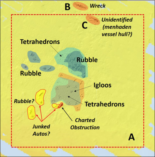
Fast forward to the data resources available today. These include a VMRC grid layout drawing and side-scan sonar coverage by NOAA, accessible using the agency’s on-line Bathymetric Data Viewer (BDV). The VMRC satellite image doesn’t include a reef layout nor is there a sonar report for this reef. The author’s assessment of material in the site and layout using available information is shown in the accompanying graphic. A substantial rubble reef as well as satellite clusters of rubble are present. Tetrahedrons are deployed in a patch reef pattern. Forty Igloos are deployed in clusters that are spread out in a broad patch reef pattern.
The identity of materials in the lower southwest corner of the site is uncertain. Of the three piles of material, my best guess is that two are the remains of the original junked cars. Some of the concrete rubble may have been placed in that general area and could be the third pile, although the VMRC grid is inconclusive. The pile on the left and the pile in the middle approximate the two parallel reef sections description. The middle reef and the pile on the right are closer to the original reef boundary. Allowing for positioning error at the time, either of the two groups could be the car bodies. There is also a charted obstruction that was not there prior to the ODU Reef. So, perhaps the obstruction designation was added when the cars were placed. There could also have been an additional placement that isn’t recorded. Maybe some enterprising diver will go down, take a look, and let us all know. Regardless, there is structure there to fish — although if a pile is full of auto bodies, it’s likely going to be a merciless snag machine.
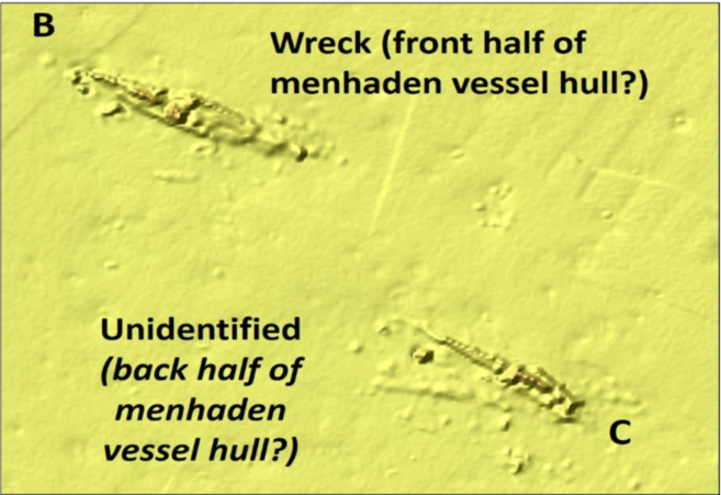
A menhaden boat was to have sunk in the site. It’s not mentioned in VMRC reef files, though AWOIS records a wreck at location B with no date or details. Its profile suggests the broken up remains of the bow of a vessel. Although the obstruction circle overlaps the north edge of the reef site, the wreck is just north of the boundary. Outside the obstruction circle at location C there is a charted anomaly within the reef site that resembles the wreckage at location B; the square end suggests that it might be the back half of a vessel. My image interpretation is that we’re looking at two halves of the same vessel, and that’s the story I’m sticking with until the mystery is otherwise resolved by an underwater inspection.
A little further up the shoreline off Ocean View at location D are a few natural features that may attract fish. But for the BDV side-scan sonar image, we wouldn’t know they were there without running over the top with a fishfinder or sonar. The BDV images shows three low profile mounds and a small area of rugged bottom with numerous small anomalies. An old oyster reef, perhaps? Although not large structures, they stand out in an otherwise unremarkable bottom and may be worth a look if other spots aren’t producing.
The fish haven is a short run to the west for recreational fishermen out of the Little Creek Inlet area and it has a selection of reef fishing options. A three and a half mile run to the northeast puts fishermen at the Chesapeake Bay Bridge-Tunnel southern islands. Don’t forget to check out the charted obstruction on the east side of the southernmost island, where there’s an unintended fishing reef… but more on that at another time.
- For a directory to more reefs Wayne has detailed, check out our Chesapeake Bay Fishing Reefs Guide.
-By Wayne Young. Wayne is the author of “Bridges Under Troubled Waters: Upper Chesapeake and Tidal Potomac Fishing Reefs,” “Chesapeake Bay Fishing Reefs, Voyage of Discovery,” “Phantoms of the Lower Bay,” and “Hook, Line, and Slinker.” All are available at Amazon.com, and you can find his Facebook page at Chesapeake Bay Fishing Reefs.
Sign up here to get the weekly FishTalk Chesapeake Bay and Mid-Atlantic fishing reports in your email inbox, every Friday by noon.