Those little nondescript obstruction circles on nautical charts tell us something is there, but many of the marked obstructions are small and not much of a fishing destination. However, sometimes what lies under a circle is a surprise. Two mystery reefs south of Cedar Point in the main stem Bay fall into that category.
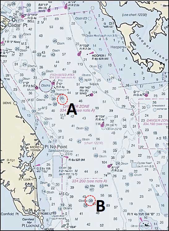
Having previously found a Bay “mystery reef” reviewing NOAA side-scan sonar images, another look while preparing for an off-season artificial reef presentation yielded an unexpected result. This former reef manager was shocked at what popped up on the screen – a large "unknown" artificial reef. It has 14 precast concrete objects and two to three smaller pieces. More startling, no such reef or fish haven was in reef files or shown on nautical charts. It wasn't a random dump of materials of opportunity; some of the objects are laid in a pattern on top of others. The reef was deliberately constructed. If not a State artificial reef, how did it get there?
The number 14 struck a memory of something seen in the NOAA Wrecks and Obstructions database. Taking another look, there it was. Fourteen concrete roadbed segments were lost overboard in 1993, about 600 yards northeast of the Cove Point gas dock. The lost sections were removed from the bottom for transport to, and off loading at, the Point No Point Fish Haven to establish an artificial reef in late 1996. The goods never made it there.
Here's the back story insofar as can be pieced together some 22 years later. Fourteen 40- by 18-foot by nine-foot precast bridge segments were en route to Chesapeake, Maryland. They were destined for use in constructing a replacement for the Summit Bridge across the Chesapeake and Delaware Canal. They were lost overboard due to unknown reasons, probably rough surface conditions that resulted in shifting cargo aboard the transport vessels. Three years later, removal was conducted by a marine contractor (three fishable objects remain at the original location). The Maryland Department of Natural Resources (DNR) authorized deployment of these materials of opportunity in the Point No Point Fish Haven. Instead, the materials were placed 4.7 nautical miles due north of the northeast corner of that fish haven. A possible navigational plotting error? Maybe. Anecdotal information suggests that a closer suitable site not part of the artificial reef program was available, and the material was deposited there. But, information to confirm this scenario has been elusive.
The reef deployment occurred about the time DNR dropped the reef program (and reef manager positions) as a budget austerity measure. Information about the new reef didn't make it into NOAA data, onto nautical charts as a new fish haven, or into the reef files that were transferred along with the reef permit to the Maryland Environmental Service (MES). The program stayed with MES as a (barely) self-supporting not-for-profit enterprise, until the permits went back to DNR after creation of the Maryland Artificial Reef Initiative (MARI). The consequence: institutional knowledge of the new reef was lost to the program in the shuffle. Finding this reef for fishing was left to chance.
Perhaps a few local fishermen know what's hiding under the obstruction circle northeast of a Point No Point. If so, they haven't been talking. Why give away a quality reef no one else knows about? But NOAA sonar imagery has let this cat out of the bag. Plus, the recovered material was intended for use as a public artificial reef. And what a reef! It's about 150 feet long, 60 feet wide, seven to 10 feet high, with least water depths of about 35 feet. It bears 146 degrees true, 7.1 nautical miles from Cedar Point, and is centered around 38’12.086N 76’ 17.446W. This is a fishing destination worth a look and jig or two when passing by.
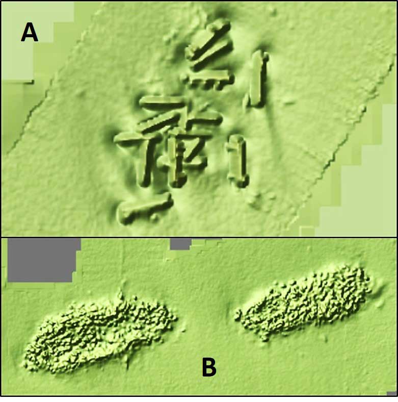
Now, about that other mystery reef. What it is and its history remain the mystery. NOAA side-scan sonar reveals two similarly shaped objects. They bear 053 degrees true, 4.7 nautical miles from Point Lookout Light. The objects appear heavily encrusted and extend across the obstruction circle centered at 38’4.288N 76’14.661W. Least water depth is charted as 39 feet. The reefs appear to rise about four to five feet above the surrounding bottom based on charted depths. No information was found in AWOIS or anywhere else about what they are or how they got there. If anyone fishes them, they’re not talking either.
The objects look like two sunken scows oriented in a west-southwest/east-northeast direction. More mysterious is the shape and configuration of whatever is covering them. Objects with a barrel-like shape are inside and outside of the frame-like perimeter of each object. They look like cargo, some of which spilled over the gunnels. One is wider than the other, probably the result of cargo dispersal. Approximate dimensions for the western object are 180 feet long and 60 feet wide. The eastern object is about 180 feet long and 40 feet wide. Whatever is there sure looks fishable for jigging, although watch for hang ups due the rough surface. Start with an unpainted lead head with a trailer to test jigging conditions, and don't use anything you don't want to lose.
Nautical chart markings, although not inaccurate since what is under the circles are obstructions, nevertheless don’t convey the actual character of what is down there. NOAA previously administratively adjusted the charted boundary of the Cedar Point Fish Haven to capture materials that were deposited outside the permitted reef boundary. These materials were placed using Loran-C positioning, and Loran-C error resulted in some rock piles and tetrahedrons being slightly outside the reef boundary. Also, a fish haven was added to nautical charts (but wasn’t incorporated into the artificial reef program) when materials destined for the Tolchester Fish Haven were positioned a quarter mile to the east, when a buoy used for positioning was off-station. Considering these two Bay area charting precedents, the obstruction circle marking the artificial reef northeast of Point No Point should be changed to a fish haven. The obstruction circle marking the wreckage with spilled cargo northeast of Point Lookout should be changed to a wreck symbol.
See our Chesapeake Bay Fishing Reefs Guide to get the lowdown on other mad-made wreck and reef hotspots in the Bay, plus a few in the ocean off the DelMarVa coast.
This article is a partial chapter excerpt from “Bridges Under Troubled Waters: Upper Chesapeake and Tidal Potomac Fishing Reefs,” reprinted with the permission of author Wayne Young. Young is a former manager of the Maryland artificial reef program for Bay waters and his new book describes artificial reefs, oyster bars, rocks, ruins, wrecks, and obstructions in the Maryland portions of the Chesapeake Bay and tidal Potomac River, as well as where and how to find them. We read it, and found gobs of very cool info for anglers — lots more like what you just read above. Purchase Bridges Under Troubled Waters at Amazon.
Sign up here to get the weekly FishTalk Chesapeake Bay and Mid-Atlantic fishing reports in your email inbox, every Friday by noon.