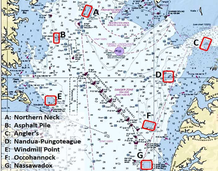
Last month we looked at Southern Maryland fishing reefs, resulting from the Maryland DNR Artificial Reefs Program. Virginia also has many reefs anglers should know about. Located southeast of the San Marcos target on the eastern side of the Bay, Nandua-Pungoteague Fish Haven is an interesting one. Several relatively large natural formations are within, adjacent, or near the reef boundary. Proximity increases the potential for biological interaction between natural reefs and artificial structures. Although not evident from standard nautical charts, considerable natural reef structure exists in Chesapeake Bay open water areas. Electronic sonar charts fill in bathymetry detail and help us find structure to fish. Even so, bottom structure is a remnant of what was formerly there. Sedimentation and aggressive harvesting of vast oyster reefs by commercial oyster dredges took their toll. What was once rugged habitat with substantial vertical relief became flat and smooth. Artificial reef development helps restore vertical relief structure. Marine organisms that colonize reef structure then help increase localized biological carrying capacity for other marine species that use reef structure for cover or foraging. Artificial fishing reefs also have potential for natural oyster colonization. The resulting reefs provide fishing opportunity.
Artificial reefs can be built to reestablish vertical relief in areas that formerly had such structure. Manmade structures are also an option for unremarkable bottom areas where environmental conditions favor establishing reefs with vertical relief. Putting an artificial reef near natural formations is another approach. This can aid in increasing local biological productivity where this can be accomplished without disrupting natural reef performance. Artificial reefs in Virginia and Maryland were established across this range of bottom types.
Many Virginia Marine Resources Commission (VMRC) artificial reefs were placed using marine construction equipment. This was made possible by strong funding support from fishing license fees, large donations of materials of opportunity that could be nested (such as concrete pipes) or layered (like concrete beams), and prefabricated units that could be placed in an upright position. Reef materials and designed reef structures were typically put in geometric patterns or for certain materials of opportunity, layered to increase vertical relief. Some of the Virginia reef sites also have natural bottom features within or in close proximity to their boundary. Seven fish havens in the northern portion of the Lower Bay have some or all of these characteristics. Of these, Nandua-Pungoteague Artificial Reef isn’t unique, but is nevertheless particularly interesting.
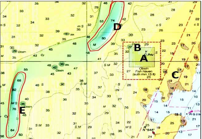
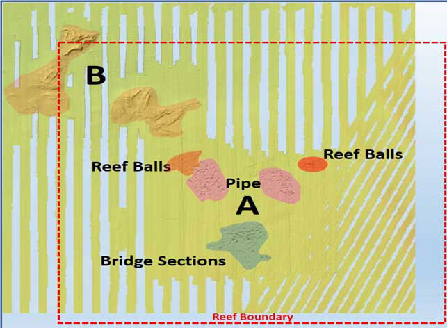
Five locations with artificial materials are around the middle of the site (location A). A very rugged natural reef straddles the upper northwest corner and the adjacent obstruction circle (location B). A less pronounced bottom anomaly is east of the southeast corner (location C). There are two deep-water trenches nearby, one to the northwest and one to the southwest. Each has a steep edge with a bottom anomaly (at locations D and E). A small obstruction immediately to the northeast of E is small and is smooth in appearance, suggesting that it is mostly covered with sediment. There’s an obstruction and a wreck between the two trenches. NOAA side-scan sonar of these two objects is unremarkable. They both are small and offer little mass to find and fish.
NOAA side-scan sonar images for this fish haven are available through the agency’s Bathymetry Data Viewer. Sonar coverage includes both the artificial materials and the natural formations. The author-prepared annotated layout graphic was derived by comparing VMRC reef data with the sonar images. The original grid pattern was overlain on a screenshot from the Viewer of the side-scan sonar image under a translucent nautical raster chart. The position of material recorded in the grid was compared and correlated with an overlay image of reef locations from VMRC’s artificial reef map. Natural formations are shaded in light orange. The reef material colors correspond to the color scheme used in the VMRC grid. Layout graphics are an approximation based on available information.
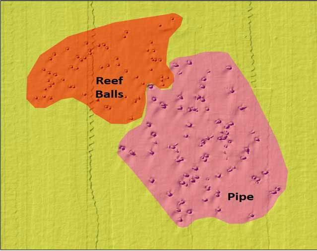
Side-scan sonar imagery reveals that reef ball and pipe units were placed individually or in small clusters using a “patch” pattern (that is, spread out across a target area). These structures will snag hooks, although they are friendlier to tackle than concrete rubble and bridge section reefs. A patch configuration also allows anchoring anywhere around the perimeter, which aids in positioning to establish a chum line or float live baits back to the reef. Scour areas on the southwest side of the modules indicates that there is a strong current flow from the north-northeast. Setting up on the northeast side during ebbs would generally provide the strongest current conditions across the reefs.
In a patch reef, each designed reef or pipe module or cluster of modules functions independently. A cluster provides surface area equivalent to that of a single larger unit. Structure height above the bottom puts marine organisms into current flow and better water quality. Vertical relief also mitigates the effects of progressive sediment accumulation. Although each unit or cluster is somewhat isolated from others in the patch, they are still close enough for predators to cruise among them looking for prey. It might appear that the patch reef configuration at Nandua-Pungoteague is too spread out to improve carrying capacity or serve as a productive fishing destination. However, various studies found that where reef units are somewhat isolated from each other, they tend to develop more biomass than a single larger reef structure of equivalent overall mass.
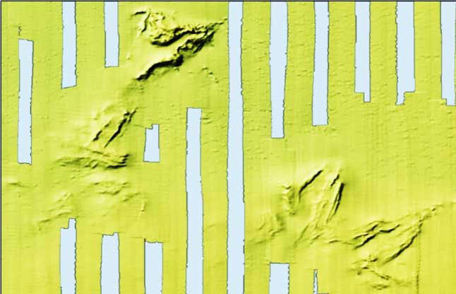
NOAA obstruction and wreck data don’t provide any clues about the composition of the natural formations at the northwest corner. If the features were “oyster rock,” that is, a vertical reef consisting of an oyster shell core, it is unlikely they would have survived mechanical dredging pressure. The sharp lines shown in the NOAA side-scan sonar image suggest natural rock outcroppings. If hard rock, it is also likely an active or remnant oyster reef as well, just one that mechanical dredges couldn’t whack. Regardless, it’s reef structure that can be fished with chum lines, live bait, or jigs.
With the variety of reef structures that are available, Nandua-Pungoteague Artificial Reef is well worth a look the next time you’re out fishing in this section of the Chesapeake.
See our Chesapeake Bay Fishing Reefs Guide to get the lowdown on other mad-made wreck and reef hotspots in the Bay, plus a few in the ocean off the DelMarVa coast.
-By Wayne Young. Young is a former manager of the Maryland artificial reef program for Bay waters and has a new book about fishing reefs in the Bay called “Bridges Under Troubled Waters: Upper Chesapeake and Tidal Potomac Fishing Reefs.”
Sign up here to get the weekly FishTalk Chesapeake Bay and Mid-Atlantic fishing reports in your email inbox, every Friday by noon.