The only constant in Chesapeake Bay fishing is that it’s a sea of change. Whether it’s daily, seasonal, or long-term, the Bay’s environmental, biological, and physical conditions are continually evolving. Artificial reef structures, whether they’re part of Bay restoration projects or fishing reefs, are an important part of this changing “Bayscape.” Once reef structure is deployed it immediately provides structural habitat in the form of substrates and vertical relief, depending on what is deployed and how it’s configured. Where deposited materials rise from the bottom they serve as a core that, in the case of coral and oyster reefs, would otherwise take nature years to progressively build. This core jumpstarts the establishment of three-dimensional reef structure. As the surface is progressively colonized by a veneer of marine life, biological performance improves. Creatures grow, finfish arrive, and these reefs begin functioning naturally in very short timeframes. Knowing where they are adds quality fishing destinations to your chartplotter.
Restoration of oyster reefs is an especially important part of the changing Bayscape, not only because of the oyster’s ability to filter water and improve clarity, but also because of the biologically productive habitat provided for prey and predators. When established parallel and close to shorelines in shallow waters, oyster and similar reef structures can also dissipate wave energy and reduce shoreline erosion.
A good example is the two reef ball breakwaters placed in front of eroding cliffs at Chesapeake Ranch Estates. Stymied in their efforts to stabilize the cliffs due to the presence of the endangered tiger beetle, which nests in the eroding cliff surface, homeowners were able to obtain approval for breakwaters formed using large reef balls. Placed in triple lines just offshore, the breakwaters dissipate wave energy and reduce shoreline erosion without disrupting beetle habitat. Lucky for we anglers, current interacting with the structures provides foraging conditions favored by predators such as striped bass, structure for natural oyster spat sets, and colonization by other marine life. For light-tackle fishermen, there are two living breakwaters to prospect.
A major oyster restoration project for 10 Bay tributaries has resulted in numerous oyster reefs, many with large acreage consisting of barge-deployed granite substrate and oyster spat on shell. Oyster reefs of this type have been established in Harris Creek and the Tred Avon, Little Choptank, and upper St Mary’s Rivers in Maryland, and the Great Wicomico, Piankatank, lower York, and Lafayette Rivers in Virginia. Project reefs are also being established in the Manokin River in Maryland and the Lynnhaven River in Virginia. The latter includes approximately 28,000 small reef balls on six inches of crushed granite and six inches of shell. The eastern branch of the Elizabeth River was subsequently added to the project.
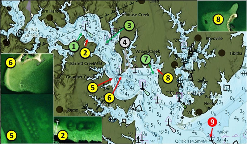
Near-shore oyster reefs consisting of both individual and lines of granite piles up to several hundred yards long were established as part of the project, notably in the Great Wicomico and Piankatank Rivers. Some are charted and some aren’t. The charted positions tend to be slightly different than positions observed using color relief sonar data and satellite images. But when you find them, these oyster reefs provide fishing opportunities for white perch and spot and may also attract larger foraging predators.
Crushed granite piles and shell deposits are located in the Great Wicomico at various project sites as shown by Chart 1. Sites 1, 3 and 7 shown as green circles are large oyster reefs. Sites 2, 5 and 8 in yellow circles mark the location of crushed granite piles. Site 2 has three large rock piles. Site 5 is the most substantial, consisting of a 200-yard-long linear reef in two lines of unequal length with at least 20 rock piles. Site 8 has two small rock piles. Site 4 marked by a grey circle consists of breakwaters on the east side of Haynie Point and the east side of the entrance to Whays Creek. They’re unrelated to the oyster restoration project but are worth a quick look when fishing. Site 6 marks three unidentified objects at coordinates 37°49.825 x 76°18.889, on top of the shoal. Water depth is very shallow but accessible by kayak.
Site 9 brings us to the last vestige of Great Wicomico River Lighthouse, which was southeast of Fleeton Point just on the southeast edge of Goffs Shoal and marked the entrance to Ingram Bay. Although unrelated to oyster restoration, put this one on your fishing hotspot list but also recognize the danger it presents. The lighthouse served from 1889 until 1967. A skeletal steel tower was built on the screwpile foundation. The Coast Guard found the light structurally unsound in 2014 and dismantled it in 2015. Nowhere in the record is there a mention of an icebreaker, but the light was charted inside a riprap symbol on raster charts. A huge rockpile is at coordinates 37°48.251 x 76°16.035. A single rock symbol is charted with depths of about 12’ around the huge circular pile. It’s about 500’ due north of Great Wicomico River Wreck Light “WR4.” Approach very carefully especially inasmuch as the steel tower is no longer there to provide a visual frame of reference and the rockpile has a history of being struck by unwary boaters.
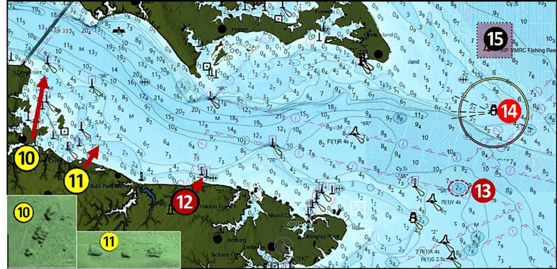
Although not part of the 10-river project, there are several restored oyster reefs in the lower Rappahannock River to check out as well. Each consists of three piles in a line at Sites 10 and 11 marked by yellow circles on Chart 2.
There are many places along Bay and tributary shorelines where there are submerged breakwaters and failed shoreline protection works. The Rappahannock River is no exception. At Site 12, there’s a rock feature that boaters and fishers should be aware of on the south side inside the river entrance off the north end of North End Road at Grinels. Look for a long, submerged rock breakwater with a short dogleg in the middle. Center-point coordinates for a small, tight gap just east of the dogleg between the warning markers are 37°34.503 x 76° 21.445. This feature was at the end of a dock that is said to have been the North End ferry landing. The dock is shown on a 1933 nautical chart but by 1960 it was charted as a submerged breakwater.
When fishing out of the Rappahannock be sure to check the nine-foot least-depth obstruction marked as Site 13 at coordinates 37°34.305 x 76°15.029. Historic records strongly suggest that this is the wreck of the 251’ target ship USS Katahdin, used as a platform for testing armor plates as protection against naval gunfire.
Site 14 marks the icebreaker rocks at Windmill Point Light, originally a screw-pile structure. Three separate deployments resulted in deposits of 2,323 tons of riprap around the structure to protect it from moving ice fields and ice floes from the Rappahannock River and from ice floes coming down the Bay. Most of the rock was deposited around the outside of the steel piles below the surface. So, although beaten down over the years, there’s a lot of rock there to attract fish. Also check the Windmill Point Fish Haven at Site 15, which holds a combination of natural and artificial structure (see “Chesapeake Bay Fishing Reefs,” Young, 2020).
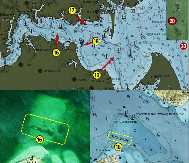
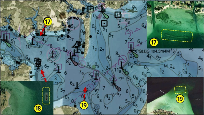
Moving to the Piankatank River, look for more oyster restoration project rockpiles shown by Chart 3. Site 16 marks a charted linear reef that’s about 325 yards long. Water depth around the reef is about five feet at Mean Low Water. Deeper water up to 16’ is nearby off each end. Check this reef when current is running. Another long reef is at Site 17. This one runs approximately east-west and measures about 220 yards. It’s a continuous narrow line of rock that is, in effect, a submerged breakwater. Adjacent depth is about six to seven feet. Site 18 marks two elongated rockpiles which are 365 yards long with surrounding water depth of 10’ to 11’. Yet another long linear rockpile reef is marked as Site 19. This 290 yard long reef is oriented approximately east-west in eight feet of water. Look for it at coordinates 37°30.670 x 76°19.981.
As the Bayscape changes, so to do our fishing options. Recently deployed structures we’ve visited today provide substantial marine habitat with cover for prey and ambush zones for foraging predators. Adding these sites to your fishing playbook is a solid move.
-By Wayne Young
As well as being a regular contributor to FishTalk, Wayne Young is the author of multiple books detailing wrecks and fishing reefs in the Chesapeake Bay, Delaware Bay, and beyond. All are available at Amazon.com, and you can find his Facebook page at “Chesapeake Bay Fishing Reefs.”